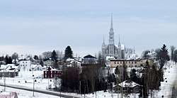
Saints-Anges, Quebec
| Saints-Anges | |
|---|---|
| Parish municipality | |
 | |
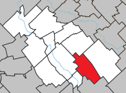 Location within La Nouvelle-Beauce RCM. | |
 Saints-Anges Location in southern Quebec. | |
| Coordinates: 46°25′N 70°53′W / 46.417°N 70.883°WCoordinates: 46°25′N 70°53′W / 46.417°N 70.883°W[1] | |
| Country |
|
| Province |
|
| Region | Chaudière-Appalaches |
| RCM | La Nouvelle-Beauce |
| Constituted | December 29, 1880 |
| Government[2] | |
| • Mayor | Jean-Marie Pouliot |
| • Federal riding | Beauce |
| • Prov. riding | Beauce-Nord |
| Area[2][3] | |
| • Total | 69.50 km2 (26.83 sq mi) |
| • Land | 69.03 km2 (26.65 sq mi) |
| Population (2011)[3] | |
| • Total | 1,149 |
| • Density | 16.6/km2 (43/sq mi) |
| • Pop 2006-2011 |
|
| • Dwellings | 456 |
| Time zone | UTC−5 (EST) |
| • Summer (DST) | UTC−4 (EDT) |
| Postal code(s) | G0S 3E0 |
| Area code(s) | 418 and 581 |
| Highways |
|
Saints-Anges is a parish in the Municipalité régionale de comté de la Nouvelle-Beauce in Quebec, Canada. It is part of the Chaudière-Appalaches region and the population is 1,026 as of 2009.
The town was established in 1880, with part of the seigneurie of Sainte-Marie.
References
- Commission de toponymie du Québec
- Ministère des Affaires municipales, des Régions et de l'Occupation du territoire
Places adjacent to Saints-Anges, Quebec | |
|---|---|
| Cities & Towns | |
|---|---|
| Municipalities | |
| Parishes | |
| |
This article is issued from
Wikipedia.
The text is licensed under Creative Commons - Attribution - Sharealike.
Additional terms may apply for the media files.