Schorfheide, Brandenburg
| Schorfheide | ||
|---|---|---|
| ||
 Schorfheide Location of Schorfheide within Barnim district 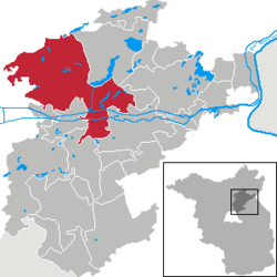 | ||
| Coordinates: 52°54′N 13°31′E / 52.900°N 13.517°ECoordinates: 52°54′N 13°31′E / 52.900°N 13.517°E | ||
| Country | Germany | |
| State | Brandenburg | |
| District | Barnim | |
| Government | ||
| • Mayor | Uwe Schoknecht (Free Voters) | |
| Area | ||
| • Total | 236.79 km2 (91.43 sq mi) | |
| Elevation | 29 m (95 ft) | |
| Population (2017-12-31)[1] | ||
| • Total | 9,947 | |
| • Density | 42/km2 (110/sq mi) | |
| Time zone | CET/CEST (UTC+1/+2) | |
| Postal codes | 16230, 16244, 16348 | |
| Dialling codes | 03334, 03335 | |
| Vehicle registration | BAR | |
| Website | Official site (in German) | |

Schorfheide is a municipality in the Barnim district of Brandenburg, Germany. It was established in 2003 by the merger of Finowfurt and Groß Schönebeck.
Overview
Schorfheide further comprises the villages of Altenhof, Böhmerheide, Eichhorst, Klandorf, Lichterfelde, Schluft and Werbellin. It is situated immediately west of the district's capital Eberswalde and about 40 km (25 mi) northeast of the Berlin city centre. Schorfheide is the largest municipality of Barnim by area. Large parts belong to the Schorfheide-Chorin Biosphere Reserve.
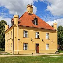
In the 13th century the Ascanian margraves of Brandenburg built a castle at the southern end of the Werbellinsee. In 1879 Prince Charles of Prussia had the Ascania Tower erected at the site. Groß Schönebeck houses a hunting lodge erected from 1680 at the behest of the Brandenburg Elector Frederick William I of Hohenzollern, now a museum. From 1950 until 1989 Altenhof was the site of the Pionierrepublik Wilhelm Pieck, a large camp of the Ernst Thälmann Pioneer Organisation.
Demography
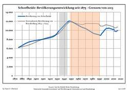 Development of Population since 1875 within the Current Boundaries (Blue Line: Population; Dotted Line: Comparison to Population Development of Brandenburg state; Grey Background: Time of Nazi rule; Red Background: Time of Communist rule)
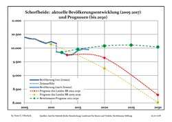 Recent Population Development and Projections (Population Development before Census 2011 (blue line); Recent Population Development according to the Census in Germany in 2011 (blue bordered line); Projection by the Brandenburg state for 2005-2030 (yellow line); Projection by the Brandenburg state for 2014-2030 (red line); Projection by the Bertelsmann Foundation for 2012-2030 (green line)
| Schorfheide: Population development within the current boundaries (2017)[2] | ||||||||||||||||||||||||||||||||||||||||||||||||||||||||||||||||||||||||||||||||||||||||||||||||||||||||||||||||||||||||||||||||||||||
|---|---|---|---|---|---|---|---|---|---|---|---|---|---|---|---|---|---|---|---|---|---|---|---|---|---|---|---|---|---|---|---|---|---|---|---|---|---|---|---|---|---|---|---|---|---|---|---|---|---|---|---|---|---|---|---|---|---|---|---|---|---|---|---|---|---|---|---|---|---|---|---|---|---|---|---|---|---|---|---|---|---|---|---|---|---|---|---|---|---|---|---|---|---|---|---|---|---|---|---|---|---|---|---|---|---|---|---|---|---|---|---|---|---|---|---|---|---|---|---|---|---|---|---|---|---|---|---|---|---|---|---|---|---|---|
|
|
| ||||||||||||||||||||||||||||||||||||||||||||||||||||||||||||||||||||||||||||||||||||||||||||||||||||||||||||||||||||||||||||||||||||
Twin towns


References
- ↑ "Bevölkerung im Land Brandenburg nach amtsfreien Gemeinden, Ämtern und Gemeinden 31. Dezember 2017 (Fortgeschriebene amtliche Einwohnerzahlen auf Grundlage des Zensus 2011)". Amt für Statistik Berlin-Brandenburg (in German). 2018.
- ↑ Detailed data sources are to be found in the Wikimedia Commons.Population Projection Brandenburg at Wikimedia Commons
External links
![]()
Towns and municipalities in Barnim district | ||
|---|---|---|
| Authority control |
|---|