Biesenthal
| Biesenthal | ||
|---|---|---|
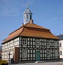
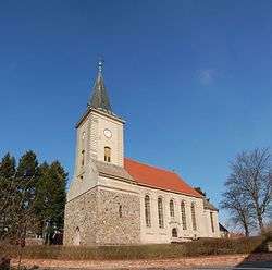 Parish church | ||
| ||
 Biesenthal Location of Biesenthal within Barnim district 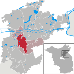 | ||
| Coordinates: 52°46′0″N 13°37′59″E / 52.76667°N 13.63306°ECoordinates: 52°46′0″N 13°37′59″E / 52.76667°N 13.63306°E | ||
| Country | Germany | |
| State | Brandenburg | |
| District | Barnim | |
| Municipal assoc. | Biesenthal-Barnim | |
| Government | ||
| • Mayor | Carsten Bruch (CDU) | |
| Area | ||
| • Total | 60.48 km2 (23.35 sq mi) | |
| Elevation | 50 m (160 ft) | |
| Population (2017-12-31)[1] | ||
| • Total | 5,734 | |
| • Density | 95/km2 (250/sq mi) | |
| Time zone | CET/CEST (UTC+1/+2) | |
| Postal codes | 16359 | |
| Dialling codes | 03337 | |
| Vehicle registration | BAR | |
| Website | www.biesenthal.de | |

Biesenthal is a town in the district of Barnim in Brandenburg, Germany. It is the administrative seat of the Amt ("municipal federation") Biesenthal-Barnim.
Geography
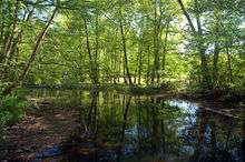
The town is located on the Finow river, about 31 km (19 mi) northeast of Berlin (centre). The surrounding Biesenthal Basin is part of the Barnim Plateau and the Barnim Nature Park, characterised by numerous kames and glacial lakes stemming from the Weichselian glaciation.
History
In the early Middle Ages, the region was settled by Polabian Slavs. Conquered by the Ascanian margraves of Brandenburg, Bizdal was first mentioned in a 1258 deed. A local parish was already documented in 1265; the present-day fieldstone church was probably erected at this time. The settlement on the Via Imperii trade route to Berlin was vested with market rights by Margrave John V in 1315.
A castle was mentioned in 1337, it was purchased by the Hohenzollern elector John George of Brandenburg in 1577. Its ruins were cleared away after the Thirty Years' War, only ground walls remained. In 1907, a view tower (Kaiser-Friedrich-Turm) was erected on the castle hill.
During the 18th century, the townscape was devastated by several blazes. The economic development was decisively promoted by the opening of the Berlin–Szczecin railway line in 1843. In World War II, a subcamp of the Sachsenhausen concentration camp was located here. The town was occupied by Red Army forces in 1945 and became part of the Soviet occupation zone.
Demography
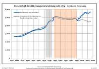
| Biesenthal: Population development within the current boundaries (2017)[2] | ||||||||||||||||||||||||||||||||||||||||||||||||||||||||||||||||||||||||||||||||||||||||||||||||||||||||||||||||||||||||||||||||||||||
|---|---|---|---|---|---|---|---|---|---|---|---|---|---|---|---|---|---|---|---|---|---|---|---|---|---|---|---|---|---|---|---|---|---|---|---|---|---|---|---|---|---|---|---|---|---|---|---|---|---|---|---|---|---|---|---|---|---|---|---|---|---|---|---|---|---|---|---|---|---|---|---|---|---|---|---|---|---|---|---|---|---|---|---|---|---|---|---|---|---|---|---|---|---|---|---|---|---|---|---|---|---|---|---|---|---|---|---|---|---|---|---|---|---|---|---|---|---|---|---|---|---|---|---|---|---|---|---|---|---|---|---|---|---|---|
|
|
| ||||||||||||||||||||||||||||||||||||||||||||||||||||||||||||||||||||||||||||||||||||||||||||||||||||||||||||||||||||||||||||||||||||
Politics
Seats in the town's assembly (Stadtverordnetenversammlung) as of 2014 local elections:
- The Left: 6
- Christian Democratic Union of Germany (CDU): 4
- Bürger für Biesenthal (independent): 3
- Alliance '90/The Greens: 2
- Social Democratic Party of Germany (SPD): 2
- Pro Danewitz (independent): 1
Notable people
- Jürgen Paeke (born 1948), gymnast
- Max Schmeling (1905-2005), world boxing champion, frequent guest at the training camp in Biesenthal
- Heinz Graffunder (1926-1994), city architect in Berlin; lived in Biesenthal
- Joachim Ziesche (born 1939), ice hockey player, lives in Biesenthal
References
- ↑ "Bevölkerung im Land Brandenburg nach amtsfreien Gemeinden, Ämtern und Gemeinden 31. Dezember 2017 (Fortgeschriebene amtliche Einwohnerzahlen auf Grundlage des Zensus 2011)". Amt für Statistik Berlin-Brandenburg (in German). 2018.
- ↑ Detailed data sources are to be found in the Wikimedia Commons.Population Projection Brandenburg at Wikimedia Commons
External links
| Wikimedia Commons has media related to Biesenthal. |
- Municipal site (in German)
Towns and municipalities in Barnim district | ||
|---|---|---|