Ahrensfelde
| Ahrensfelde | ||
|---|---|---|
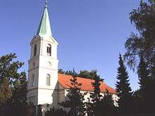
 Aerial view of Ahrensfelde (foreground) with Berlin-Marzahn housing estates (background) | ||
| ||
 Ahrensfelde Location of Ahrensfelde within Barnim district 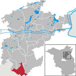 | ||
| Coordinates: 52°34′33″N 13°34′35″E / 52.57583°N 13.57639°ECoordinates: 52°34′33″N 13°34′35″E / 52.57583°N 13.57639°E | ||
| Country | Germany | |
| State | Brandenburg | |
| District | Barnim | |
| Government | ||
| • Mayor | Wilfried Gehrke (CDU) | |
| Area | ||
| • Total | 57.74 km2 (22.29 sq mi) | |
| Elevation | 56-85 m (−223 ft) | |
| Population (2017-12-31)[1] | ||
| • Total | 13,307 | |
| • Density | 230/km2 (600/sq mi) | |
| Time zone | CET/CEST (UTC+1/+2) | |
| Postal codes | 16356 | |
| Dialling codes | 030 | |
| Vehicle registration | BAR | |
| Website | www.ahrensfelde.de | |

Ahrensfelde is a municipality in the district of Barnim, in Brandenburg, Germany. It is situated on the Barnim Plateau at the city limits of Berlin, about 13 km (8.1 mi) northeast of the city centre. The municipal area comprises the villages of Ahrensfelde, Blumberg, Eiche, Lindenberg, and Mehrow.
History
Ahrensfelde, like the neighbouring village of Eiche, was first mentioned in the 1375 Landbuch (domesday book) survey executed for Emperor Charles IV, after he had acquired the Margraviate of Brandenburg two years before. The oldest village however is Blumberg, once a possession held by the Bishops of Brandenburg, which was first mentioned as Blumenberch in 1253. Blumberg manor was acquired by the poet and diplomat Friedrich von Canitz in the late 17th century, the castle was later rebuilt according to plans by Karl Friedrich Schinkel with a park designed by Peter Joseph Lenné. It was destroyed by the advancing Red Army during the 1945 Battle of Berlin. The art historian Adolf Bötticher was a native of Blumberg.
In 1908 the Ahrensfelde Cemetery was established by the Evangelical Church of the Prussian Union as a multi-regional burial site outside of Berlin. Parts of the municipal area near Ahrensfelde station were overbuilt and finally incorporated into the East Berlin borough of Marzahn in 1990. The present-day municipality was established by the merger of Ahrensfelde proper with Blumberg, Eiche and Lindeberg on 26 October 2003.
Demography
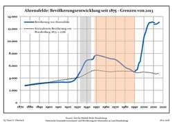 Development of Population since 1875 within the Current Boundaries (Blue Line: Population; Dotted Line: Comparison to Population Development of Brandenburg state; Grey Background: Time of Nazi rule; Red Background: Time of Communist rule)
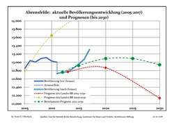 Recent Population Development and Projections (Population Development before Census 2011 (blue line); Recent Population Development according to the Census in Germany in 2011 (blue bordered line); Projection by the Brandenburg state for 2005-2030 (yellow line); Projection by the Brandenburg state for 2014-2030 (red line); Projection by the Bertelsmann Foundation for 2012-2030 (green line)
| Ahrensfelde: Population development within the current boundaries (2017)[2] | ||||||||||||||||||||||||||||||||||||||||||||||||||||||||||||||||||||||||||||||||||||||||||||||||||||||||||||||||||||||||||||||||||||||
|---|---|---|---|---|---|---|---|---|---|---|---|---|---|---|---|---|---|---|---|---|---|---|---|---|---|---|---|---|---|---|---|---|---|---|---|---|---|---|---|---|---|---|---|---|---|---|---|---|---|---|---|---|---|---|---|---|---|---|---|---|---|---|---|---|---|---|---|---|---|---|---|---|---|---|---|---|---|---|---|---|---|---|---|---|---|---|---|---|---|---|---|---|---|---|---|---|---|---|---|---|---|---|---|---|---|---|---|---|---|---|---|---|---|---|---|---|---|---|---|---|---|---|---|---|---|---|---|---|---|---|---|---|---|---|
|
|
| ||||||||||||||||||||||||||||||||||||||||||||||||||||||||||||||||||||||||||||||||||||||||||||||||||||||||||||||||||||||||||||||||||||
Politics
Seats in the municipal assembly (Gemeindevertretung) as of the 2008 local election:
- Free Voters: 6
- Christian Democratic Union: 5
- The Left: 4
- Social Democratic Party of Germany: 3
- "Citizens' Association Eiche": 2
- Free Democratic Party: 1
- "The Independent": 1
References
- ↑ "Bevölkerung im Land Brandenburg nach amtsfreien Gemeinden, Ämtern und Gemeinden 31. Dezember 2017 (Fortgeschriebene amtliche Einwohnerzahlen auf Grundlage des Zensus 2011)". Amt für Statistik Berlin-Brandenburg (in German). 2018.
- ↑ Detailed data sources are to be found in the Wikimedia Commons.Population Projection Brandenburg at Wikimedia Commons
Towns and municipalities in Barnim district | ||
|---|---|---|
| Authority control |
|---|