Panketal
| Panketal | ||
|---|---|---|
| ||
 Panketal Location of Panketal within Barnim district 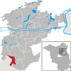 | ||
| Coordinates: 52°37′59″N 13°33′00″E / 52.63306°N 13.55000°ECoordinates: 52°37′59″N 13°33′00″E / 52.63306°N 13.55000°E | ||
| Country | Germany | |
| State | Brandenburg | |
| District | Barnim | |
| Government | ||
| • Mayor | Maximilian Wonke (SPD) | |
| Area | ||
| • Total | 25.84 km2 (9.98 sq mi) | |
| Elevation | 60 m (200 ft) | |
| Population (2017-12-31)[1] | ||
| • Total | 20,390 | |
| • Density | 790/km2 (2,000/sq mi) | |
| Time zone | CET/CEST (UTC+1/+2) | |
| Postal codes | 16341 | |
| Dialling codes | 030 | |
| Vehicle registration | BAR | |
| Website | www.panketal.de | |

Panketal is a municipality in the district of Barnim, in Brandenburg, Germany. It is situated 15 km northeast of Berlin (centre).
History
Panketal emerged in 2003 by merging the municipalities Zepernick and Schwanebeck. Since 1996, the population increased by 52.8%.[2]
Demography
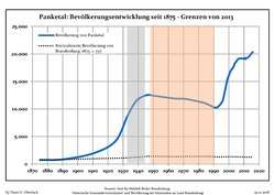 Development of Population since 1875 within the Current Boundaries (Blue Line: Population; Dotted Line: Comparison to Population Development of Brandenburg state; Grey Background: Time of Nazi rule; Red Background: Time of Communist rule)
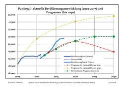 Recent Population Development and Projections (Population Development before Census 2011 (blue line); Recent Population Development according to the Census in Germany in 2011 (blue bordered line); Projection by the Brandenburg state for 2005-2030 (yellow line); Projection by the Brandenburg state for 2014-2030 (red line); Projection by Bertelsmann-Stiftung 2012 (green line)
| Panketal: Population development within the current boundaries (2017)[3] | ||||||||||||||||||||||||||||||||||||||||||||||||||||||||||||||||||||||||||||||||||||||||||||||||||||||||||||||||||||||||||||||||||||||
|---|---|---|---|---|---|---|---|---|---|---|---|---|---|---|---|---|---|---|---|---|---|---|---|---|---|---|---|---|---|---|---|---|---|---|---|---|---|---|---|---|---|---|---|---|---|---|---|---|---|---|---|---|---|---|---|---|---|---|---|---|---|---|---|---|---|---|---|---|---|---|---|---|---|---|---|---|---|---|---|---|---|---|---|---|---|---|---|---|---|---|---|---|---|---|---|---|---|---|---|---|---|---|---|---|---|---|---|---|---|---|---|---|---|---|---|---|---|---|---|---|---|---|---|---|---|---|---|---|---|---|---|---|---|---|
|
|
| ||||||||||||||||||||||||||||||||||||||||||||||||||||||||||||||||||||||||||||||||||||||||||||||||||||||||||||||||||||||||||||||||||||
Recreation
In 2006 a ropes course has been set up in the district Hobrechtsfelde. The ropes course has some 20 different training units. It was subsidized by Panketal with a total sum of 150,000 €.[4]
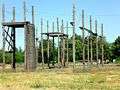 Ropes course in the climbing garden at Hobrechtsfelde
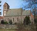 Church in Schwanebeck
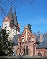 Church in Zepernick
 Former granary in Hobrechtsfelde
 View point in Hobrechtsfelde
References
- ↑ "Bevölkerung im Land Brandenburg nach amtsfreien Gemeinden, Ämtern und Gemeinden 31. Dezember 2017 (Fortgeschriebene amtliche Einwohnerzahlen auf Grundlage des Zensus 2011)". Amt für Statistik Berlin-Brandenburg (in German). 2018.
- ↑ "Archived copy". Archived from the original on 2009-06-15. Retrieved 2009-03-10.
- ↑ Detailed data sources are to be found in the Wikimedia Commons.Population Projection Brandenburg at Wikimedia Commons
- ↑ "Archived copy". Archived from the original on 2009-02-08. Retrieved 2009-03-10.
External links
Towns and municipalities in Barnim district | ||
|---|---|---|
This article is issued from
Wikipedia.
The text is licensed under Creative Commons - Attribution - Sharealike.
Additional terms may apply for the media files.