Chorin
| Chorin | |
|---|---|
 Brick Gothic Chorin Abbey | |
 Chorin Location of Chorin within Barnim district  | |
| Coordinates: 52°54′0″N 13°52′0″E / 52.90000°N 13.86667°ECoordinates: 52°54′0″N 13°52′0″E / 52.90000°N 13.86667°E | |
| Country | Germany |
| State | Brandenburg |
| District | Barnim |
| Municipal assoc. | Britz-Chorin-Oderberg |
| Government | |
| • Mayor | Martin Horst (Ind.) |
| Area | |
| • Total | 121.62 km2 (46.96 sq mi) |
| Elevation | 55 m (180 ft) |
| Population (2017-12-31)[1] | |
| • Total | 2,318 |
| • Density | 19/km2 (49/sq mi) |
| Time zone | CET/CEST (UTC+1/+2) |
| Postal codes | 16230 |
| Dialling codes | 033366 |
| Vehicle registration | BAR |
| Website | www.britz-chorin.de |
Chorin is a municipality in the district of Barnim in Brandenburg, Germany. It is most famous for its cloister and for being situated within the Schorfheide-Chorin Biosphere Reserve. It is famous for its medieval Brick Gothic Chorin Abbey and the Choriner Musiksommer music festival held there.
Demography
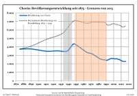
Development of population since 1875 within the current boundaries (Blue line: Population; Dotted line: Comparison to population development of Brandenburg state; Grey background: Time of Nazi rule; Red background: Time of communist rule)
| Chorin: Population development within the current boundaries (2017)[2] | ||||||||||||||||||||||||||||||||||||||||||||||||||||||||||||||||||||||||||||||||||||||||||||||||||||||||||||||||||||||||||||||||||||||
|---|---|---|---|---|---|---|---|---|---|---|---|---|---|---|---|---|---|---|---|---|---|---|---|---|---|---|---|---|---|---|---|---|---|---|---|---|---|---|---|---|---|---|---|---|---|---|---|---|---|---|---|---|---|---|---|---|---|---|---|---|---|---|---|---|---|---|---|---|---|---|---|---|---|---|---|---|---|---|---|---|---|---|---|---|---|---|---|---|---|---|---|---|---|---|---|---|---|---|---|---|---|---|---|---|---|---|---|---|---|---|---|---|---|---|---|---|---|---|---|---|---|---|---|---|---|---|---|---|---|---|---|---|---|---|
|
|
| ||||||||||||||||||||||||||||||||||||||||||||||||||||||||||||||||||||||||||||||||||||||||||||||||||||||||||||||||||||||||||||||||||||
See also
References
- ↑ "Bevölkerung im Land Brandenburg nach amtsfreien Gemeinden, Ämtern und Gemeinden 31. Dezember 2017 (Fortgeschriebene amtliche Einwohnerzahlen auf Grundlage des Zensus 2011)". Amt für Statistik Berlin-Brandenburg (in German). 2018.
- ↑ Detailed data sources are to be found in the Wikimedia Commons.Population Projection Brandenburg at Wikimedia Commons
External links
![]()
- Chorin at britz-chorin-oderberg.de (German infopage)
- www.Kloster-Chorin.info (German website about Chorin Abbey)
Towns and municipalities in Barnim district | ||
|---|---|---|
| Authority control |
|---|
This article is issued from
Wikipedia.
The text is licensed under Creative Commons - Attribution - Sharealike.
Additional terms may apply for the media files.