Sarasota–Bradenton International Airport
| Sarasota–Bradenton International Airport | |||||||||||||||
|---|---|---|---|---|---|---|---|---|---|---|---|---|---|---|---|
|
| |||||||||||||||
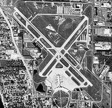 USGS 1998 orthophoto | |||||||||||||||
| Summary | |||||||||||||||
| Airport type | Public | ||||||||||||||
| Owner | Sarasota Manatee Airport Authority | ||||||||||||||
| Serves | Sarasota metropolitan area | ||||||||||||||
| Location |
Sarasota, Florida Manatee / Sarasota counties | ||||||||||||||
| Opened | May 1941 | ||||||||||||||
| Elevation AMSL | 30 ft / 9 m | ||||||||||||||
| Coordinates | 27°23′44″N 082°33′16″W / 27.39556°N 82.55444°WCoordinates: 27°23′44″N 082°33′16″W / 27.39556°N 82.55444°W | ||||||||||||||
| Website |
srq-airport | ||||||||||||||
| Maps | |||||||||||||||
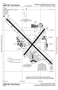 FAA diagram | |||||||||||||||
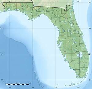 SRQ Location of airport in Florida / United States  SRQ SRQ (the US) | |||||||||||||||
| Runways | |||||||||||||||
| |||||||||||||||
| Statistics (2016) | |||||||||||||||
| |||||||||||||||
Sarasota–Bradenton International Airport (IATA: SRQ[3], ICAO: KSRQ, FAA LID: SRQ) is located partially within Sarasota County, City of Sarasota, and Manatee County. Owned by the Sarasota Manatee Airport Authority, it is three miles north of downtown Sarasota[2] and six miles south of Bradenton.[4]
The National Plan of Integrated Airport Systems for 2017–2021 called it a "small hub" airport since it enplanes 0.05 percent to 0.25 percent of total U.S. passenger enplanements.[5]
History
Origins
Before the Sarasota-Bradenton Airport was built, both Sarasota and Bradenton had their own airfields. Bradenton's Bradenton Airport and Sarasota's Lowe Field with both of them being unpaved. Bradenton Airport was abandoned at an unknown point before World War 2 while Sarasota's Lowe Airfield was abandoned in 1961.[6][7] The airport was agreed to be built in 1939 and by May 1941 the Sarasota Manatee Airport Authority was created.
In the 1940s, SRQ was known by its two-character designation, RS. By 1948, growth in aviation demand prompted IATA to coordinate the assignment of three-character codes. The airport initially received the designation "SSO", a short-lived code subject to misinterpretation as the international distress signal, SOS. SRQ was chosen, with "Q" serving as filler text.[8] The airport's IATA airport code, "SRQ", is used as a general nickname for the city of Sarasota and Sarasota area, as exemplified by media outlets like SRQ Magazine,[9] WSRQ radio,[10] and numerous local businesses in the area that include SRQ in their names.
World War II
In 1942 with the United States entering World War 2 the airport was leased to the Army Air Corps and became known as the Sarasota Army Airfield. The Army Air Corps later added 250 acres making the airport 870 acres. The 97th Bombardment Group was later transferred from MacDill Air Force Base in Tampa for training with B-17 Flying Fortresses. In June the base was designated a sub base and changed it's focus from bombers to fighters because the runways could not withstand the weight of bombers. The 69th Fighter Squadron transferred to the airfield from Drew Army Airfield to train with P-39 Airacobras. Sarasota had sub bases in Bartow, St. Petersburg, Fort Myers, and Tampa. While; Immokalee, Lake Wales, Punta Gorda and Winter Haven served as auxiliary fields for the base. In 1947, the base was transferred back to civilian use.[11]
Post–World War II expansion
National Airlines was SRQ's first airline, moving from Sarasota's Lowe's Field by 1947; the April 1957 OAG shows six NA departures a day. By June 1959, Sarasota had built a new terminal building for the airport featuring a control tower, a ticketing area, offices, gift shop, coffee shop and a balcony where passengers could watch there planes fly in. Eastern arrived in 1961 and the airport's first jet flights were Eastern 727s in winter 1964–65 (though the longest runway was 5006 ft for a few years after that). It was also reported that by 1959 the airport had roughly 22,000 annual passengers. By the 1960s the airport along with Eastern and National Airlines got two commuter airlines; Executive in 1964 and Florida Air in 1968. Executive even established Sarasota as there southern operations and maintenance base. They flew flights between from Sarasota to Tampa and Fort Myers.[12]
In 1978, there was a controversial proposal to move the airport by both Sarasota County and Manatee County due to airport overcrowding.[13]
September 11 attacks
Air Force One was at the airport on September 11, 2001. George W. Bush was at the Emma E. Booker Elementary School in Sarasota when Andrew Card first informed him of the September 11, 2001 attacks at 9:05 AM. Bush returned to the airport. The 747 taxied out at 9:54 AM and took off from runway 14 at 9:55 AM flying first to Barksdale Air Force Base in Louisiana.[14]
Like many American airports, Sarasota–Bradenton International Airport experienced financial woes after the September 11, 2001 attacks with airlines leaving, such as Canada 3000.
2003 – present
In 2003 AirTran Airways began service after a nationwide marketing poll by the airline. AirTran added service to Hartsfield–Jackson Atlanta International Airport, and Baltimore–Washington International Airport, and by 2011 the airline served six U.S. cities nonstop from SRQ.
In September 2005 Delta Air Lines, the carrier with the largest market share out of SRQ,[15] filed for Chapter 11 bankruptcy. While initially there was concern regarding Delta's bankruptcy filing's effect on the financial stability of the airport, especially if Delta were to have reduced local operations, in fact Delta has since announced new service out of SRQ, with more flights to Atlanta and new service to New York LaGuardia Airport and Boston. All of that service was cut back or discontinued, but Delta recently announced new winter/spring seasonal service to Boston and LaGuardia.
In January 2012, AirTran Airways announced that it would drop SRQ on August 12, 2012 as part of its merger with Southwest.[16]
The airport has two fixed-base operators; Rectrix Aviation and Dolphin Aviation.
Governance
The current President, CEO is Fredrick "Rick" J. Piccolo. The airport is governed by the Sarasota Manatee Airport Authority. The board is six governor appointed individuals, three from Sarasota County and three from Manatee County, since the airport has portions in each county.[17]
Facilities
The airport covers 1,102 acres (446 ha) at an elevation of 30 feet (9 m). It has two asphalt runways: 14/32 is 9,500 by 150 feet (2,896 x 46 m) and 4/22 is 5,009 by 150 feet (1,527 x 46 m).[2]
In 2013 the airport had 103,411 aircraft operations, average 283 per day: 78% general aviation, 13% airline, 7% air taxi, and 2% military. 247 aircraft were then based at this airport: 69% single-engine, 14% jet, 13% multi-engine, and 4% helicopter.[2]
Airlines and destinations
Passenger
| Airlines | Destinations | Refs |
|---|---|---|
| Air Canada Rouge | Seasonal: Toronto–Pearson | |
| Allegiant Air | Cincinnati, Indianapolis, Pittsburgh[19] | |
| American Airlines | Seasonal: Charlotte (begins December 19, 2018)[20] | |
| American Eagle | Charlotte, Washington–National Seasonal: Chicago–O'Hare (resumes December 19, 2018),[21] Dallas/Fort Worth (begins December 19, 2018),[22] Philadelphia (begins January 12, 2019)[23] | |
| Delta Air Lines | Atlanta Seasonal: Detroit, New York–LaGuardia | |
| Delta Connection | New York–LaGuardia Seasonal: Boston (resumes March 2, 2019),[24] New York–JFK | |
| Elite Airways | Portland (ME)[25] | |
| Frontier Airlines | Seasonal: Atlanta (begins December 10, 2018), Cleveland (begins December 14, 2018), Philadelphia (begins December 10, 2018) | [26] |
| JetBlue Airways | New York–JFK Seasonal: Boston | |
| Sun Country Airlines | Seasonal charter: Gulfport/Biloxi | |
| United Airlines | Chicago–O'Hare, Newark | |
| United Express | Chicago–O'Hare, Newark |
| Destinations map |
|---|
 Sarasota-Bradenton All destinations from Sarasota-Bradenton International Airport (SRQ). |
Statistics
Top airlines
| Rank | Carrier | Passengers | Change
2016/17 |
Market
share |
|---|---|---|---|---|
| 1 | Delta Air Lines | 650,580 | 58.46% | |
| 2 | American Airlines | 211,000 | 18.59% | |
| 3 | JetBlue Airways | 137,000 | 12.32% | |
| 4 | United Airlines | 74,800 | 6.73% | |
| Others | 39,360 | 3.54% | ||
| Total | 1,112,740 |
Top domestic destinations
| Rank | City | Passengers | Change
2016/17 |
Carriers |
|---|---|---|---|---|
| 1 | Atlanta, Georgia | 291,410 | Delta | |
| 2 | Charlotte, North Carolina | 84,780 | American | |
| 3 | New York–JFK, New York | 41,710 | Delta, JetBlue | |
| 4 | Chicago–O'Hare, Illinois | 31,950 | United | |
| 5 | Boston, Massachusetts | 27,670 | JetBlue | |
| 6 | New York–La Guardia, New York | 27,380 | Delta | |
| 7 | Washington–National, D.C | 21,330 | American | |
| 8 | Newark, New Jersey | 21,290 | United | |
| 9 | Detroit, Michigan | 7,730 | Delta | |
| 10 | Portland, Maine | 3,970 | new | Elite |
Annual enplanements
The table lists annual enplanements from the Federal Aviation Administration's Terminal Area Forecast 2011.[29] An enplanement is a revenue generating passenger boarding an aircraft.[30]
| Year | Air Carrier | Commuter | International | Total |
|---|---|---|---|---|
| 2004 | 430,554 | 123,036 | 0 | 553,590 |
| 2005 | 496,976 | 135,148 | 3,144 | 635,268 |
| 2006 | 514,406 | 159,983 | 12,828 | 687,217 |
| 2007 | 608,983 | 170,184 | 8,805 | 787,972 |
| 2008 | 577,942 | 186,256 | 9,013 | 773,211 |
| 2009 | 507,162 | 153,639 | 9,904 | 670,705 |
| 2010 | 514,986 | 134,339 | 10,980 | 660,305 |
| Year | Enplanements | Deplanements | Total |
|---|---|---|---|
| 2011 | 658,929 | 647,535 | 1,306,464 |
| 2012 | 640,458 | 632,457 | 1,272,915 |
| 2013 | 595,604 | 592,286 | 1,187,890 |
| 2014 | 601,486 | 595,611 | 1,197,097 |
| 2015 | 612,438 | 607,925 | 1,220,363 |
| 2016 | 594,167 | 592,252 | 1,186,419 |
| 2017 | 593,830 | 587,502 | 1,181,332 |
References
- 1 2 "December Y2016 Monthly Report" (PDF). SRQ Airport. Retrieved August 1, 2018.
- 1 2 3 4 FAA Airport Master Record for SRQ (Form 5010 PDF). Federal Aviation Administration. effective November 15, 2012.
- ↑ "IATA Airport code Search (SRQ: Sarasota / Bradenton)". International Air Transport Association. Retrieved December 31, 2012.
- ↑ "Distance and heading from Bradenton (27°29'N 82°35'W) to KSRQ (27°23'44"N 82°33'16"W)". Great Circle Mapper. Retrieved December 31, 2012.
- ↑ "2017–2021 NPIAS Report, Appendix B" (PDF). Federal Aviation Administration. Federal Aviation Administration. Retrieved August 13, 2018.
- ↑ "Municipal Airport/Lowe Field | Sarasota History Alive!". www.sarasotahistoryalive.com. Retrieved 2018-08-08.
- ↑ "Abandoned & Little-Known Airfields: Florida, Southern Tampa area". www.airfields-freeman.com. Retrieved 2018-07-23.
- ↑ "Frequently Asked Questions". SRQ Airport. 2015-11-01. Retrieved 2018-01-23.
- ↑ "SRQ: Living Local in Sarasota and Bradenton Florida". srqmagazine.com.
- ↑ "WSRQ Sarasota 98.9 FM 106.9 FM 1220 AM - Sarasota Talk Radio -". sarasotatalkradio.com.
- ↑ "Florida's World War II Memorial".
- ↑ "History of airline service at Sarasota". Sunshine Skies. Retrieved 2018-07-26.
- ↑ "St. Petersburg Times - Google News Archive Search". news.google.com. Retrieved 2017-03-11.
- ↑ Pool news report by Judy Keen and Jay Carney on September 11, 2001, posted on USA Today Sept. 11 Resources Archived February 24, 2011, at the Wayback Machine.
- ↑ Archived May 19, 2006, at the Wayback Machine.
- ↑ Jacobs, Karen (January 20, 2012). "Southwest says AirTran to exit six airports". Reuters.
- ↑ "Airport History". srq-airport.com. Sarasota Manatee Airport Authority. Archived from the original on March 17, 2013. Retrieved February 26, 2013.
- ↑ http://srq-airport.com/nonstop-destinations
- ↑ "Allegiant adds two new cities in six-route expansion". Usatoday.com. 2018-01-09. Retrieved 2018-01-23.
- ↑ http://www.heraldtribune.com/news/20180924/american-adding-flights-from-philadelphia-to-sarasota-bradenton
- ↑ https://www.bizjournals.com/tampabay/news/2018/06/25/american-airlines-to-launch-chicago-service-from.html
- ↑ https://www.bizjournals.com/dallas/news/2018/05/31/american-airlines-dfw-routes-del-rio-texas.html?ana=RSS&s=article_search
- ↑ http://www.heraldtribune.com/news/20180924/american-adding-flights-from-philadelphia-to-sarasota-bradenton
- ↑ "Delta resumes Boston – Sarasota service in 1Q19". RoutesOnline. September 4, 2018. Retrieved September 4, 2018.
- ↑ http://www.aviationpros.com/news/12405248/brief-elite-airways-has-a-new-flight-plan-for-srq
- ↑ "Frontier adds two Florida airports in 11-route expansion". Retrieved 15 August 2018.
- ↑ "OST_R | BTS | Transtats". www.transtats.bts.gov. Retrieved 2018-03-25.
- ↑ "RITA | BTS | Transtats". transtats.bts.gov. Dec 2017. Retrieved March 25, 2018.
- ↑ "APO Terminal Area Forecast 2011". Federal Aviation Administration. Retrieved December 31, 2012.
- ↑ "About TAF (Terminal Area Forecast)". Federal Aviation Administration. Retrieved December 31, 2012.
External links
- Sarasota Bradenton International Airport, official site
- Sarasota/Bradenton Regional Airport 1959–1989 at the Wayback Machine (archived October 14, 2008)
- History of Airline Service at Sarasota 1930s-1960s
- Sarasota Bradenton Airport in the 1970s, An extensive history of airline service
- FAA Airport Diagram (PDF), effective October 11, 2018
- FAA Terminal Procedures for SRQ, effective October 11, 2018
- Resources for this airport:
- AirNav airport information for KSRQ
- ASN accident history for SRQ
- FlightAware airport information and live flight tracker
- NOAA/NWS latest weather observations
- SkyVector aeronautical chart for KSRQ
- FAA current SRQ delay information