Carrabelle–Thompson Airport
| Carrabelle–Thompson Airport (former Carrabelle Flight Strip) | |||||||||||
|---|---|---|---|---|---|---|---|---|---|---|---|
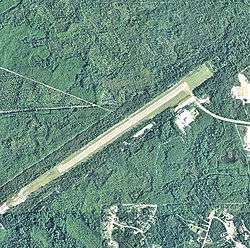 USGS 2006 orthophoto | |||||||||||
| Summary | |||||||||||
| Airport type | Public | ||||||||||
| Owner | Carrabelle Port and Airport Authority | ||||||||||
| Serves | Carrabelle, Florida | ||||||||||
| Elevation AMSL | 20 ft / 6 m | ||||||||||
| Coordinates | 29°50′31″N 084°42′04″W / 29.84194°N 84.70111°WCoordinates: 29°50′31″N 084°42′04″W / 29.84194°N 84.70111°W | ||||||||||
| Map | |||||||||||
 X13 Location of airport in Florida | |||||||||||
| Runways | |||||||||||
| |||||||||||
| Statistics (2009) | |||||||||||
| |||||||||||
Carrabelle–Thompson Airport (FAA LID: X13) is a public use airport located three nautical miles (6 km) west of the central business district of Carrabelle, a city in Franklin County, Florida, United States. It is owned by the Carrabelle Port and Airport Authority.[1]
History
During World War II, the facility was built in 1943 by the United States Army Air Forces as a Third Air Force auxiliary landing field known as Carrabelle Flight Strip. During the war, it served as an auxiliary airfield, controlled by Dale Mabry Army Airfield near Tallahassee. No permanent units were assigned to the airfield.
Turned over to civil use after the war, it is now a public airport providing general aviation service.
Facilities and aircraft
Carrabelle–Thompson Airport covers an area of 202 acres (82 ha) at an elevation of 20 feet (6 m) above mean sea level. It has one runway designated 5/23 with an asphalt surface measuring 4,000 by 75 feet (1,219 x 23 m). For the 12-month period ending August 28, 2009, the airport had 524 aircraft operations, an average of 43 per month: 95% general aviation and 5% military.[1]
See also
References
![]()
- Shaw, Frederick J. (2004), Locating Air Force Base Sites History’s Legacy, Air Force History and Museums Program, United States Air Force, Washington DC, 2004.
External links
- Resources for this airport:
- FAA airport information for X13
- AirNav airport information for X13
- FlightAware airport information and live flight tracker
- SkyVector aeronautical chart for X13
.svg.png)