Mazhanadu
| Mazhanadu மழநாடு Mazhavarnadu | |
|---|---|
| Geographical area | |
| Nickname(s): Steel City | |
| Country |
|
| Region | South India |
| Government | |
| • Body | Government of Tamil Nadu |
| Languages | |
| • Official | Tamil |
| Time zone | UTC+5:30 (IST) |
| PIN | 620-636xxx |
| Vehicle registration | TN 24, TN 27, TN 28, TN 29, TN 30,TN 34, TN 45, TN 46, TN 48, TN 52, TN 54, TN 61, TN 70, TN 77, TN 88, TN 90, TN 93 |
| Largest city | Salem |
| Civic agency | Government of Tamil Nadu |
Mazhanadu is a region between Northern parts of Trichy and southern parts of Bengaluru which was called as Erumai Nadu. It includes the Districts of Salem, Namakkal, Dharmapuri, Krishnagiri,Ariyalur and western parts of Thiruvannamalai. In ancient sangam age this region was ruled by Mazhavar kings. Famous Sangam poetess Avvaiyar had cordial relation with the Tamil Mazhavar chieftains like Athiyamān Nedumān Añci of Thagadoor and Valvil Ori of Kollimalai. Mazhanadu was divided into two major divisions namely Mel-Mazhanadu (Western Mazhanadu)[1][2] and Keezh-Mazhanadu (Eastern-Mazhanadu). The Keezh-Mazhanadu was once ruled by Kolli Mazhavan and his successors. The Keezh-Mazhanadu was well known by its water resources. It was mentioned in a Tamil poem.[3]
Mazhanadu region
The table below lists geographic and demographic parameters for districts that constitute the 'Mazhanaduregion' of Tamil Nadu.
| S.No. | Districts | Headquarters | Established | Area (km²) | Population (2011 Census) | Population density (/km²) | Taluks | Map | |
|---|---|---|---|---|---|---|---|---|---|
| 1 | Salem | Salem | 1 November 1956 | 5,205 | 3,482,056[4] | 669 | 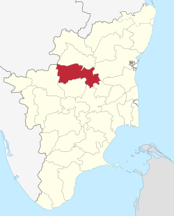 | ||
| 2 | Dharmapuri | Dharmapuri | 2 October 1965 | 4,497.77 | 1,506,843[5] | 335 | 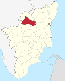 | ||
| 3 | Namakkal | Namakkal | 1 January 1997 | 3363 | 1,726,601[6] | 513 | 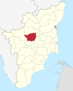 | ||
| 4 | Krishnagiri | Krishnagiri | 9 February 2004 | 5,143 | 1,879,809[7] | 366 | 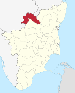 | ||
| 5 | Ariyalur | Ariyalur | 1,949.31 | 752,481 | 390 | ||||
| 6 | Thiruvannamalai | Thiruvannamalai | }
References
|