Indira Col
| Indira Col | |
|---|---|
| Elevation | 5,764 m (18,911 ft) |
| Location | On the border between China and the Siachen Glacier region controlled by India, (disputed by Pakistan).[1] |
| Range | Eastern Karakoram Range |
| Coordinates | 35°39′52″N 76°47′52″E / 35.66444°N 76.79778°ECoordinates: 35°39′52″N 76°47′52″E / 35.66444°N 76.79778°E |
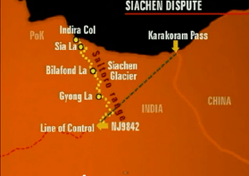
The Indira Col (altitude 5,764 metres (18,911 ft)) is a col (mountain pass, also called La in the local language) on the Indira Ridge in the Siachen Muztagh in the Karakoram Range. It is within 3 km of Sia Kangri to the west, the summit of which is the tripoint where territories controlled by India, Pakistan, and China meet.
The col is a saddle between the Siachen Glacier to the south and the Urdok Glacier to the north, on the watershed between the Indus River basin and the Tarim Basin. It is too steep to easily descend north from the col to the Urdok Glacier.[2]
The term Indira Col has also been applied to another, higher col 2.4 km further east on the Indira Ridge at (altitude 5,988 metres (19,646 ft)), from which it is possible to descend to the north.[2] This eastern col was named Indira Col in 1912 by Bullock Workman, after one of the names of the goddess Lakshmi.[3]
Colonel Narendra "Bull" Kumar reached Indira Col (the western col) in 1981.[4][5][6] In 1998 Harish Kapadia reached the same col; on his map and text he refers to it as the "main Indira Col" and "Indira Col West", whereas he refers to the col 2.4 km to the east as "Indira Col East (Workman)." [7]
The Indira Col is 2 km east of the point (about a km southeast of the peak of Sia Kangri) where the Actual Ground Position Line between Indian and Pakistani forces meets the border with China.[7] Territories on all sides are disputed. The land immediately to the south of the col is claimed by both Pakistan and India and is controlled by India. The land to the north of Indira Col is part of the Trans-Karakoram Tract, controlled by China under a 1963 border agreement with Pakistan but claimed by India.[8]
See also
References
- ↑ India is in de facto control of this region of Kashmir; the Indian claim is disputed by Pakistan. See e.g. The Future of Kashmir on the BBC website.
- 1 2 Kapadia, Harish (1998). "On the Siachen Glacier, Part 4". Indian Mountaineering Federation. Archived from the original on 2011-07-26. Retrieved 2010-08-23.
- ↑ Kapadia, Harish (1998). "On the Siachen Glacier, Part 2". Indian Mountaineering Federation. Archived from the original on 2011-07-26. Retrieved 2010-08-23.
- ↑ Bull’s glacier
- ↑ The Colonel Who Got Us Siachen
- ↑ Ice Station Taurus
- 1 2 Kapadia, Harish (1999). Across Peaks & Passes in Ladakh, Zanskar & East Karakoram. New Delhi, India: Indus Publishing Company. pp. 94, 186–89, 195. ISBN 81-7387-100-0.
- ↑ The Geographer. Office of the Geographer. Bureau of Intelligence and Research. Department of State, United States of America (November 15, 1968), China – Pakistan Boundary (PDF), International Boundary Study, 85, Florida State University College of Law