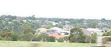
Walkley Heights, South Australia
| Walkley Heights Adelaide, South Australia | |||||||||||||||
|---|---|---|---|---|---|---|---|---|---|---|---|---|---|---|---|
 Walkley Heights reserve | |||||||||||||||
| Population | 3,224 (2006 census)[1] | ||||||||||||||
| Established | 1995 | ||||||||||||||
| Postcode(s) | 5098 | ||||||||||||||
| LGA(s) | City of Salisbury, City of Port Adelaide Enfield | ||||||||||||||
| State electorate(s) | Florey | ||||||||||||||
| Federal Division(s) | Makin | ||||||||||||||
| |||||||||||||||
Walkley Heights is a suburb of Adelaide, South Australia. The suburb is located on land formerly comprising the prison farm for Yatala Labour Prison, and includes fifty-five hectares of land formerly owned by R. M. Williams which was compulsorily acquired during the time of former State Premier Sir Thomas Playford.[2] The suburb (and one adjacent main road) is named after John Walkley, an early pioneer in South Australia[3]
The suburb had a population, in 2001, of only 713[4] increasing to 3,224 by 2006.
A small shopping centre at the end of Homestead Avenue has a Foodland supermarket, a pizza shop, a bakery, a Salvation Army opportunity shop, a beauty salon and a doctor's surgery. Also there is a childcare centre and kindergarten.
The South Australian Government has a large logistics and technical facility, used by several departments, in Wright Road at the western end of the suburb.
Environment
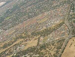
The suburb occupies 1.5 square kilometres of land either side of the Dry Creek linear park which features mature river red gums, recent landscaped plantings, and the remains of an old stockman's hut. Within the linear park is the Walkley Heights reserve where mallee box grassy woodland is actively being conserved under the Urban forest biodiversity program.[5]
See also
References
- ↑ Australian Bureau of Statistics (25 October 2007). "Walkley Heights (State Suburb)". 2006 Census QuickStats. Retrieved 25 October 2007.
- ↑ Postcards – Dry Creek – Linear Park
- ↑ www.placenames.sa.gov.au Government of South Australia, Land Services Group
- ↑ Australian Bureau of Statistics 2001 Census of Population and Housing
- ↑ Urban Forest Biodiversity Program, press release from www.urbanforest.on.net
Coordinates: 34°50′20″S 138°38′17″E / 34.839°S 138.638°E