Crystal Brook, South Australia
| Crystal Brook South Australia | |||||||||||||||
|---|---|---|---|---|---|---|---|---|---|---|---|---|---|---|---|
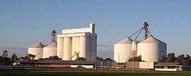 The rising sun catching the Crystal Brook grain silos on a clear winter's morning; the town sports oval in the foreground | |||||||||||||||
 Crystal Brook | |||||||||||||||
| Coordinates | 33°21′0″S 138°12′0″E / 33.35000°S 138.20000°ECoordinates: 33°21′0″S 138°12′0″E / 33.35000°S 138.20000°E | ||||||||||||||
| Population | 1,185 (2006 census)[1] | ||||||||||||||
| Postcode(s) | 5523 | ||||||||||||||
| Elevation | 105 m (344 ft)[2] | ||||||||||||||
| Location |
| ||||||||||||||
| LGA(s) | Port Pirie Regional Council | ||||||||||||||
| State electorate(s) | Frome | ||||||||||||||
| Federal Division(s) | Grey | ||||||||||||||
| |||||||||||||||
Crystal Brook is a town in South Australia, named after the spring-fed creek next to which it was founded. It is 197 kilometres (122 mi) north of Adelaide and in 2006 had a population of 1,185.[1]
Crystal Brook is situated on Goyder's Line near the border of two climate systems. While apparently cold semi-arid, the town benefits from a temperate mediterranean climate zone near to the east,[3] making possible slightly more intense farming in the region. To the west and north-west lies some marginal, semi-arid farmland. The local farming community still supports many small businesses in the town.
History
Local government
The District Council of Crystal Brook was established in 1882. It amalgamated with the District Council of Redhill in 1988 to form the District Council of Crystal Brook-Redhill which continued to be seated at Crystal Brook. From 1997 Crystal Brook has been locally governed by the Port Pirie Regional Council following a merger between Crystal Brook-Redhill and the Port Pirie City councils.
Military History
During World War 2, Crystal Brook was the location of RAAF No.31 Inland Aircraft Fuel Depot (IAFD), built in 1942 and closed on 14 June 1944. Usually consisting of 4 tanks, 31 fuel depots were built across Australia for the storage and supply of aircraft fuel for the RAAF and the US Army Air Forces at a total cost of £900,000 ($1,800,000).[4]
Infrastructure
Water
Crystal Brook (or creek) supplied water to the town until 1890 when the Beetaloo Reservoir was completed, which at the time was the largest concrete dam in the southern hemisphere.[5]
Broadband
Broadband internet became available at Crystal Brook on 16 April 2005 after lobbying from residents. Both ADSL and ADSL2+ speeds are available to residential and business customers. National Broadband Network (NBN) wired services for the township became available on 7 October 2016. The old ADSL and PSTN infrastructure is expected to be turned off about 13 April 2018. Free WI-FI is provided by the local council in the main street, for the use of travelers and locals. NBN wireless broadband and satellite is available outside of the township area.
Transport
The Sydney–Perth and the Adelaide–Darwin railways share the same approximately 530 kilometres (329 mi) of track between Crystal Brook and Tarcoola. There is a triangular junction at Crystal Brook which joins Tarcoola, Adelaide and Sydney. Another triangular junction at Tarcoola joins Crystal Brook, Darwin and Perth.
Entertainment and tourism
Crystal Brook Show
The Crystal Brook Show has been held annually since the early 1880s.[6]
Heysen Trail
The town lies on the Heysen Trail, a 1,200 kilometres (746 mi)-long walking trail from Cape Jervis to Parachilna Gorge.
Close to the north-south midpoint of the trail, Crystal Brook marks a change in climate. Hot, dry summers and mild winters lie to the north, and more temperate conditions to the south.[7]
Sport
Crystal Brook's sporting facilities cater for hockey, tennis, croquet, golf, lawn bowls, netball, basketball, swimming, gymnasium exercise, junior soccer, horse riding, motor-cross, football and cricket.
In regional competitions the town colours are red and white, with most teams known as 'The Roosters'.
The Crystal Brook Football Club won the Northern Areas (Australian Rules) Football Association premiership for a record 19th time in 2012[8] and the town has twice staged a round of the Australian motor-cross championships.
Notable people
- Arthur Percy Sullivan – recipient of the Victoria Cross
- Rob Kerin – Premier of South Australia between 22 October 2001 and 5 March 2002
References
- 1 2 Australian Bureau of Statistics (25 October 2007). "Crystal Brook (Urban Centre/Locality)". 2006 Census QuickStats. Retrieved 2007-11-18.
- ↑ South Australian Rail Public timetable 1963, pg3
- ↑ The Köppen climate classification system classifies the Crystal Brook region as BSk, or cold semi-arid, and the bordering region to the east as Csb, or temperate mediterranean
- ↑ Australia. Royal Australian Air Force. Historical Section (1995), Logistics units, AGPS Press, ISBN 978-0-644-42798-2
- ↑ Beetaloo Reservoir SA Water
- ↑ The Maitland Mercury (8 Sep 1883) quotes a Sydney 'Evening News' report that the (South Australian) Governor and Commissioner for Crown Lands departed Adelaide to attend the Crystal Brook Show
- ↑ Heysen Trail The South Australian Government's Department for Environment and Heritage (includes a map)
- ↑ Northern Areas Football Association List of Premiers from 1909 onwards
External links
- Crystal Brook (at GeoCities) for sporting and community group contacts, gardening tips, walking trails and photo gallery
- Crystal Brook Show (at GeoCities) has a comprehensive list of the show's judging program