Division of Wakefield
| Wakefield Australian House of Representatives Division | |
|---|---|
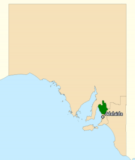 Division of Wakefield in South Australia, as of the 2016 federal election. | |
| Created | 1903 |
| MP | Nick Champion |
| Party | Labor |
| Namesake | Edward Gibbon Wakefield |
| Electors | 112,251 (2016) |
| Area | 6,407 km2 (2,473.8 sq mi) |
| Demographic | Rural |
The Division of Wakefield is an Australian electoral division in the state of South Australia. The 6,407 km² seat is a hybrid rural-urban electorate that stretches from Salisbury in the outer northern suburbs of Adelaide at the south of the seat right through to the Clare Valley at the north of the seat, 135 km from Adelaide. It includes the suburbs of Elizabeth, Craigmore, Munno Para, and part of Salisbury, and the towns of Balaklava, Clare, Freeling, Gawler, Kapunda, Mallala, Riverton, Tarlee, Virginia, Williamstown, and part of Port Wakefield.
The division was named after Edward Gibbon Wakefield, who promoted colonisation as a tool for social engineering, plans which formed the basis for settlements in South Australia, Western Australia, New Zealand and Canada. The division was one of the seven established when the multi-member Division of South Australia was redistributed into single-member seats on 2 October 1903. It was first contested at the 1903 federal election on very different boundaries. Two of the seat's former members of particular note have been the inaugural Speaker of the House and two-time Premier of South Australia, Frederick Holder, and Howard government two-term Speaker Neil Andrew.
Before 2004
Before 2004, Wakefield covered most of the eastern rural area of South Australia, and was held by the Liberal Party and its predecessors for all but five years from 1903 to 2004. For most of that time, it was a safely conservative seat. Labor only succeeded in winning it twice, at a 1938 by-election and the 1943 federal election.
In its final configuration as an exclusively rural seat, it stretched from the Yorke Peninsula in the west to the New South Wales border in the east, and included much of the Riverland. It covered the towns of Angaston, Balaklava, Barmera Berri, Gawler, Gumeracha, Kadina, Kapunda, Loxton, Minlaton, Moonta, Morgan, Mount Pleasant, Nuriootpa, Renmark, Tanunda, Waikerie, Wallaroo and Yorketown.[1]
Since 2004
The seat's character was dramatically altered by a redistribution prior to the 2004 election. Bonython, a comfortably safe Labor seat based on the outer northern suburbs of Adelaide, was abolished, and Wakefield was pushed well to the south to absorb much of Bonython's territory. In the process, Wakefield lost much of its vast rural territory, which went to Grey and Barker. Wakefield's current area of 6,407 km² is roughly a fifth of its pre-2004 extent of 31,841 km².
Neil Andrew, the seat's member since 1983, had previously held the old rural Wakefield with a comfortably safe majority of 14.6 percent. However, the new hybrid urban-rural (though still classed rural) Wakefield became a marginal Labor seat with a notional 1.3 percent two-party margin. Andrew believed this made Wakefield impossible to hold and retired. However, David Fawcett retained it for the Liberals in 2004 with a 0.7 percent two-party margin, defeating the former member for Bonython, Martyn Evans.
At the 2007 election, Nick Champion became only the third Labor member ever to win Wakefield, with a 6.6 percent two-party margin. At the 2010 election, Champion made it a safe Labor seat on paper by winning a 12 percent two-party margin. He became the first Labor member to be re-elected to Wakefield, and the second to be elected for a full term. The South Australian federal redistribution in 2011 had the greatest impact on Wakefield where the Labor margin declined by 1.5 percent. Champion retained it at the 2013 election on a 3.4 percent two-party margin even as Labor lost government, marking the first time the non-Labor parties won government at an election without winning Wakefield. Champion increased his two-party margin at the 2016 election to 11 percent, again making Wakefield a safe Labor seat on paper.
Under the electoral redistribution completed in 2018, Wakefield will be renamed Spence in honour of Catherine Helen Spence, and become an entirely urban seat based on Adelaide's northern suburbs. The more rural portions will transfer to Grey and Barker.[2]
Members
| Member | Party | Term | |
|---|---|---|---|
| Sir Frederick Holder | Independent | 1903–1909 | |
| Richard Foster | Commonwealth Liberal | 1909–1917 | |
| Nationalist | 1917–1922 | ||
| Liberal Union | 1922–1925 | ||
| Nationalist | 1925–1928 | ||
| Maurice Collins | Country | 1928–1929 | |
| Charles Hawker | Nationalist | 1929–1931 | |
| United Australia | 1931–1938 | ||
| Sydney McHugh | Labor | 1938–1940 | |
| Jack Duncan-Hughes | United Australia | 1940–1943 | |
| Albert Smith | Labor | 1943–1946 | |
| (Sir) Philip McBride | Liberal | 1946–1958 | |
| Bert Kelly | Liberal | 1958–1977 | |
| Geoffrey Giles | Liberal | 1977–1983 | |
| Neil Andrew | Liberal | 1983–2004 | |
| David Fawcett | Liberal | 2004–2007 | |
| Nick Champion | Labor | 2007–present | |
Election results
| Party | Candidate | Votes | % | ± | |
|---|---|---|---|---|---|
| Labor | Nick Champion | 38,197 | 39.82 | −1.70 | |
| Liberal | Kathleen Bourne | 25,299 | 26.37 | −11.52 | |
| Xenophon | Richard Inwood | 19,592 | 20.42 | +20.42 | |
| Family First | Marilyn Phillips | 5,396 | 5.62 | −0.36 | |
| Greens | Craig Vanstone | 4,102 | 4.28 | −0.87 | |
| Independent | John Bolton | 2,728 | 2.84 | +2.84 | |
| Christian Democrats | Ralph Anderson | 619 | 0.65 | +0.65 | |
| Total formal votes | 95,933 | 94.61 | +0.30 | ||
| Informal votes | 5,470 | 5.39 | −0.30 | ||
| Turnout | 101,403 | 90.34 | −2.77 | ||
| Two-party-preferred result | |||||
| Labor | Nick Champion | 58,494 | 60.97 | +7.57 | |
| Liberal | Kathleen Bourne | 37,439 | 39.03 | −7.57 | |
| Labor hold | Swing | +7.57 | |||
See also
References
Notes
- ↑ "Wakefield boundary map, 2001" (PDF). Australian Electoral Commission. 1999. Retrieved 22 June 2016.
- ↑ "Federal electoral divisions in South Australia formalised". Australian Electoral Commission. 20 July 2018. Retrieved 28 July 2018.
- ↑ Wakefield, SA, Virtual Tally Room 2016, Australian Electoral Commission.
External links
- SA boundary map, 2001: AEC
- SA boundary map, 1984: Atlas SA
- "Profile of the electoral division of Wakefield (SA)". Australian Electoral Commission. 2011. Retrieved 13 April 2015. (includes link to 2011 map)