Lingwick, Quebec
| Lingwick | |
|---|---|
| Township municipality | |
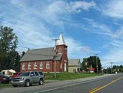 Church in Gould | |
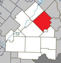 Location within Le Haut-Saint-François RCM | |
 Lingwick Location in southern Quebec | |
| Coordinates: 45°35′N 71°20′W / 45.58°N 71.33°WCoordinates: 45°35′N 71°20′W / 45.58°N 71.33°W[1] | |
| Country |
|
| Province |
|
| Region | Estrie |
| RCM | Le Haut-Saint-François |
| Constituted | July 1, 1855 |
| Government[2] | |
| • Mayor | Marcel Langlois |
| • Federal riding | Compton—Stanstead |
| • Prov. riding | Mégantic |
| Area[2][3] | |
| • Total | 249.60 km2 (96.37 sq mi) |
| • Land | 242.85 km2 (93.76 sq mi) |
| Population (2011)[3] | |
| • Total | 399 |
| • Density | 1.6/km2 (4/sq mi) |
| • Pop 2006-2011 |
|
| Time zone | UTC−5 (EST) |
| • Summer (DST) | UTC−4 (EDT) |
| Postal code(s) | J0B 2Z0 |
| Area code(s) | 819 |
| Highways |
|
| Website |
www |
Lingwick is a township of about 400 people in Le Haut-Saint-François Regional County Municipality in the Estrie region of Quebec, Canada.
It incorporates the former villages of Gould and Sainte-Marguerite.[4]
References
- ↑ Reference number 36149 of the Commission de toponymie du Québec (in French)
- 1 2 Geographic code 41085 in the official Répertoire des municipalités (in French)
- 1 2 "(Code 2441085) Census Profile". 2011 census. Statistics Canada. 2012.
- ↑ "Lingwick (Township) - Haut-Saint-François - Eastern Townships (Quebec)". Retrieved 14 November 2016.
External links

Places adjacent to Lingwick, Quebec | |
|---|---|
| Cities & Towns | |
|---|---|
| Municipalities | |
| Townships | |
| |
This article is issued from
Wikipedia.
The text is licensed under Creative Commons - Attribution - Sharealike.
Additional terms may apply for the media files.