Milan, Quebec
| Milan | |
|---|---|
| Municipality | |
 | |
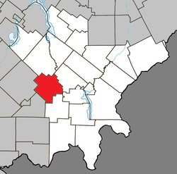 Location within Le Granit RCM | |
 Milan Location in southern Quebec | |
| Coordinates: 45°36′N 71°08′W / 45.600°N 71.133°WCoordinates: 45°36′N 71°08′W / 45.600°N 71.133°W[1] | |
| Country |
|
| Province |
|
| Region | Estrie |
| RCM | Le Granit |
| Constituted | June 1, 1948 |
| Government[2] | |
| • Mayor | Claude Turcotte |
| • Federal riding | Mégantic—L'Érable |
| • Prov. riding | Mégantic |
| Area[2][3] | |
| • Total | 130.80 km2 (50.50 sq mi) |
| • Land | 126.60 km2 (48.88 sq mi) |
| Population (2011)[3] | |
| • Total | 270 |
| • Density | 2.1/km2 (5/sq mi) |
| • Pop 2006-2011 |
|
| • Dwellings | 171 |
| Time zone | UTC−5 (EST) |
| • Summer (DST) | UTC−4 (EDT) |
| Postal code(s) | G0Y 1E0 |
| Area code(s) | 819 |
| Highways |
|
| Website |
www |
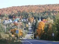
Milan is a municipality of about 300 people in Le Granit Regional County Municipality in the Estrie region in Quebec, Canada.
The community was established 1877 by Scottish immigrants from Lewis, and originally known as Marsden. Due to confusion with the township of Marston, the community's name was changed to Milan some years later.
Climate
| Climate data for Milan | |||||||||||||
|---|---|---|---|---|---|---|---|---|---|---|---|---|---|
| Month | Jan | Feb | Mar | Apr | May | Jun | Jul | Aug | Sep | Oct | Nov | Dec | Year |
| Record high °C (°F) | 16 (61) |
16 (61) |
21.5 (70.7) |
28 (82) |
30 (86) |
31.5 (88.7) |
33.3 (91.9) |
32.2 (90) |
30 (86) |
26.7 (80.1) |
21.7 (71.1) |
17.2 (63) |
33.3 (91.9) |
| Average high °C (°F) | −6.6 (20.1) |
−5.1 (22.8) |
0.7 (33.3) |
7.5 (45.5) |
16.1 (61) |
20.7 (69.3) |
22.8 (73) |
21.5 (70.7) |
16.5 (61.7) |
10 (50) |
2.7 (36.9) |
−3.7 (25.3) |
8.6 (47.5) |
| Daily mean °C (°F) | −11.9 (10.6) |
−10.6 (12.9) |
−4.8 (23.4) |
2.4 (36.3) |
10 (50) |
14.8 (58.6) |
17.3 (63.1) |
16.1 (61) |
11.3 (52.3) |
5.3 (41.5) |
−1.3 (29.7) |
−8.5 (16.7) |
3.3 (37.9) |
| Average low °C (°F) | −17.2 (1) |
−16 (3) |
−10.2 (13.6) |
−2.8 (27) |
3.9 (39) |
9 (48) |
11.7 (53.1) |
10.7 (51.3) |
6 (43) |
0.6 (33.1) |
−5.4 (22.3) |
−13.3 (8.1) |
−1.9 (28.6) |
| Record low °C (°F) | −38.3 (−36.9) |
−39 (−38) |
−34.5 (−30.1) |
−22.8 (−9) |
−12.2 (10) |
−2.2 (28) |
0 (32) |
−1.1 (30) |
−8.5 (16.7) |
−12.8 (9) |
−26 (−15) |
−35 (−31) |
−39 (−38) |
| Average precipitation mm (inches) | 105.8 (4.165) |
89.2 (3.512) |
101.1 (3.98) |
85.8 (3.378) |
105.7 (4.161) |
127.5 (5.02) |
125.9 (4.957) |
137.9 (5.429) |
115.8 (4.559) |
104.7 (4.122) |
109.8 (4.323) |
113.1 (4.453) |
1,322.4 (52.063) |
| Source: Environment Canada[4] | |||||||||||||
References
- ↑ Reference number 41064 of the Commission de toponymie du Québec (in French)
- 1 2 Geographic code 30040 in the official Répertoire des municipalités (in French)
- 1 2 "(Code 2430040) Census Profile". 2011 census. Statistics Canada. 2012.
- ↑ Environment Canada Canadian Climate Normals 1971–2000, accessed 17 July 2010
| Wikimedia Commons has media related to Milan, Quebec. |
| Cities | |
|---|---|
| Municipalities | |
| Parishes | |
| Townships | |
| |
This article is issued from
Wikipedia.
The text is licensed under Creative Commons - Attribution - Sharealike.
Additional terms may apply for the media files.