Sōja
| Sōja 総社市 | |||
|---|---|---|---|
| City | |||
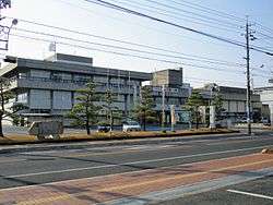 Sōja City Hall | |||
| |||
 Sōja Location in Japan | |||
| Coordinates: 34°39′33″N 133°45′58″E / 34.65917°N 133.76611°ECoordinates: 34°39′33″N 133°45′58″E / 34.65917°N 133.76611°E | |||
| Country | Japan | ||
| Region | Chūgoku (San'yō) | ||
| Prefecture | Okayama Prefecture | ||
| Government | |||
| • Mayor | Soichi Kataoka (since October 2007) | ||
| Area | |||
| • Total | 212.00 km2 (81.85 sq mi) | ||
| Population (October 1, 2016) | |||
| • Total | 67,059 | ||
| • Density | 320/km2 (820/sq mi) | ||
| Symbols | |||
| • Tree | Maple Leaf | ||
| • Flower | Astragalus | ||
| • Bird | Crane | ||
| Time zone | UTC+9 (JST) | ||
| City hall address |
1-1-1 Chuo, Soja-shi, Okayama-ken 719-1192 | ||
| Website |
www | ||

Sōja (総社市 Sōja-shi) is a city located in Okayama Prefecture, Japan.
As of October 1, 2016, the city has an estimated population of 67,059 and a population density of 320 persons per km². The total area is 212.00 km².[1]
History
In the 7th century, Ki Castle was built atop the mountain Kijōyama. Long in ruins, excavation and partial reconstruction began in 1999.
The city was founded on March 31, 1954.[1]
On March 22, 2005, the villages of Yamate and Kiyone (both from Tsukubo District) were merged into Sōja.[1]
Geography
Adjacent municipalities
Sōja is surrounded by the following cities and towns, all within Okayama Prefecture.
Rivers
- Takahashi River
- Shinpon River
- Makidani River
Mountains
- Ki castle mountain
- Mount Fuku
- Mount Karube
Sister cities
Sōja has been twinned with Chino, Nagano in Japan since 1984.[2]
References
- 1 2 3 Official website(in Japanese)
- ↑ Official website, History of Sōja Archived 2011-08-03 at the Wayback Machine. (in Japanese)
External links
| Wikimedia Commons has media related to Sōja, Okayama. |
- Sōja City official website (in Japanese)
This article is issued from
Wikipedia.
The text is licensed under Creative Commons - Attribution - Sharealike.
Additional terms may apply for the media files.