Satoshō
| Satoshō 里庄町 | |||
|---|---|---|---|
| Town | |||
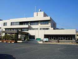 Satoshō town office | |||
| |||
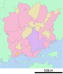 Location of Satoshō in Okayama Prefecture | |||
 Satoshō Location in Japan | |||
| Coordinates: 34°31′N 133°33′E / 34.517°N 133.550°ECoordinates: 34°31′N 133°33′E / 34.517°N 133.550°E | |||
| Country | Japan | ||
| Region |
Chūgoku San'yō | ||
| Prefecture | Okayama Prefecture | ||
| District | Asakuchi | ||
| Area | |||
| • Total | 12.23 km2 (4.72 sq mi) | ||
| Population (March 31, 2017) | |||
| • Total | 11,204 | ||
| • Density | 920/km2 (2,400/sq mi) | ||
| Symbols | |||
| • Tree | Camellia japonica | ||
| Time zone | UTC+9 (JST) | ||
| Website |
www | ||


Satoshō (里庄町 Satoshō-chō) is a town located in Asakuchi District, Okayama Prefecture, Japan.
As of March 2017, the town has an estimated population of 11,204 and a density of 920 persons per km².[1] The total area is 12.23 km².
In 2005, it declined to amalgamate with the neighboring towns of Kamogata and Yorishima to form the city of Asakuchi.
Industries include food processing factories (Amano Foods), electronics (Sharp), medicines (Fusso) etc.
Geography
Neighbouring municipalities
Transportation
Raliway
Notable people from Satoshō
- Yoshio Nishina, former physicist
- Gōtarō Ogawa, former economist, educator, politician and cabinet minister
References
- ↑ "Official website of Satoshō city" (in Japanese). Japan: Satoshō City. Retrieved 15 April 2017.
External links

- Satoshō official website (in Japanese)
This article is issued from
Wikipedia.
The text is licensed under Creative Commons - Attribution - Sharealike.
Additional terms may apply for the media files.