List of listed buildings in Rutherglen, South Lanarkshire
This is a list of listed buildings in the parish of Rutherglen in South Lanarkshire, Scotland.
List
| Name | Location | Date Listed | Grid Ref. [note 1] | Geo-coordinates | Notes | HB Number [note 2] | Image |
|---|---|---|---|---|---|---|---|
| 1-5 (Inclusive Nos) Blairbeth Terrace And 76 Blairbeth Road | 55°48′56″N 4°12′12″W / 55.815427°N 4.203214°W | Category B | 33703 |  | |||
| 14 Burnside Road, The Ingle, Including Gateway, Quadrants, Piers, Gates, Railings, Coach House/Stable Block And Summer House | 55°48′44″N 4°12′01″W / 55.812119°N 4.200218°W | Category B | 33704 | 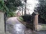 | |||
| 152, 154 Main Street, Rutherglen, Kirkwood Street, St Columbkille's RC Church And Presbytery | 55°49′39″N 4°12′50″W / 55.827594°N 4.213818°W | Category A | 33567 | 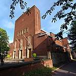 | |||
| King Street, Burgh Primary School With Boundary Walls, Railings And Gatepiers | 55°49′45″N 4°13′02″W / 55.82926°N 4.217138°W | Category B | 50135 | _2016-02-28.jpg) | |||
| 141 -147 (Odd Nos) Main Street, Rutherglen | 55°49′43″N 4°12′51″W / 55.828525°N 4.214062°W | Category C(S) | 33565 | 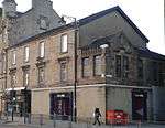 | |||
| Melrose Avenue, Rutherglen, Stonelaw High School (Main Block) | 55°49′31″N 4°12′34″W / 55.825266°N 4.209343°W | Category B | 33568 | 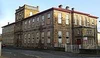 | |||
| Mill Street, Overtoun Park, Bandstand | 55°49′18″N 4°12′48″W / 55.821556°N 4.213235°W | Category B | 33569 | 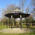 | |||
| Mill Street, Overtoun Park, Gateway | 55°49′22″N 4°12′58″W / 55.822684°N 4.216013°W | Category B | 33570 | 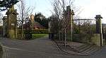 | |||
| 153 Stonelaw Road, Stonelaw Parish Church Including Gatepiers And Railings | 55°49′25″N 4°12′30″W / 55.823738°N 4.208362°W | Category B | 33573 | 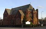 | |||
| 20-24 Queen Street And 115 King Street, Masonic Hall | 55°49′44″N 4°12′58″W / 55.828929°N 4.216065°W | Category C(S) | 50134 | 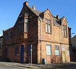 | |||
| 209 Main Street, Bower Bar | 55°49′44″N 4°12′42″W / 55.828801°N 4.211715°W | Category C(S) | 50136 | _2018-03-24.jpg) | |||
| 73 Blairbeth Road, Duncraggan, Including Gatepiers And Boundary Walls | 55°48′59″N 4°12′10″W / 55.816281°N 4.202688°W | Category B | 33702 |  | |||
| 18 Farmeloan Road, Rutherglen, Former Rutherglen East Church | 55°49′44″N 4°12′36″W / 55.82883°N 4.21005°W | Category B | 33554 | 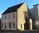 | |||
| Main Street Rutherglen, Mercat Cross | 55°49′43″N 4°12′48″W / 55.828477°N 4.213439°W | Category C(S) | 33558 | 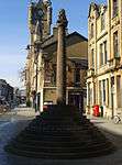 | |||
| 131, 139 Main Street, Rutherglen, District Council Offices (Originally Town Hall) | 55°49′43″N 4°12′53″W / 55.828568°N 4.214624°W | Category A | 33564 | 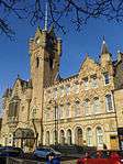 | |||
| Mill Street, Overtoun Park, Queen Victoria Jubilee Fountain | 55°49′19″N 4°12′48″W / 55.821967°N 4.213402°W | Category B | 33571 | 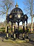 | |||
| 56,58 And 60 Main Street, Mecca Bingo (Former Vogue Cinema) | 55°49′40″N 4°13′02″W / 55.827911°N 4.217189°W | Category C(S) | 50139 | _2016-02-28.jpg) | |||
| 3 Western Avenue, Rutherglen West Parish Church (Munro Church) Church Of Scotland | 55°49′45″N 4°13′14″W / 55.829035°N 4.220638°W | Category B | 33700 | 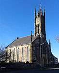 | |||
| Main Street Rutherglen, Old Parish Churchyard Including Kirk Port And Gateways | 55°49′42″N 4°12′57″W / 55.828405°N 4.2157°W | Category B | 33561 | .jpg) | |||
| 34 Broomieknow Road, Blairtum Park House Including Gatepiers | 55°49′01″N 4°12′39″W / 55.816989°N 4.210821°W | Category C(S) | 33550 | 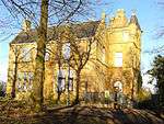 | |||
| Main Street Rutherglen, Queen Street Rutherglen Old Parish Church | 55°49′43″N 4°12′57″W / 55.828611°N 4.21576°W | Category B | 33562 | 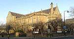 | |||
| 159, 161, 163 Main Street, Rutherglen, Post Office And Library | 55°49′43″N 4°12′50″W / 55.828692°N 4.213753°W | Category B | 33566 |  | |||
| 53 Overtoun Drive, Mill Street, Overtoun Park, Superintendent's House | 55°49′21″N 4°12′55″W / 55.822462°N 4.215362°W | Category B | 33572 | 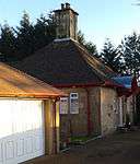 | |||
| Dalmarnock Road, Dalmarnock Bridge | 55°50′14″N 4°12′34″W / 55.837233°N 4.209575°W | Category B | 33551 |  | |||
| Main Street, Rutherglen Tower And Fragments Of Old Church | 55°49′43″N 4°12′55″W / 55.828601°N 4.215328°W | Category A | 33563 | 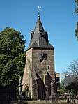 | |||
| 41 Dalmarnock Road, Rutherglen, And 1, 3 Baronald Street Including Tennents Bar | 55°50′01″N 4°12′28″W / 55.833526°N 4.207815°W | Category C(S) | 33875 | _2016-02-28.jpg) | |||
| 84, 86 Hamilton Road, Rutherglen, Cairn Hall | 55°49′35″N 4°12′23″W / 55.826425°N 4.206343°W | Category C(S) | 33555 |  | |||
| Maccallum Avenue, Rutherglen, Stonelaw High School, Gallowflat Annexe (East Block) | 55°49′37″N 4°12′20″W / 55.827041°N 4.205612°W | Category B | 33557 | | |||
| 63, 65 Main Street, Rutherglen, Narplan House | 55°49′43″N 4°13′02″W / 55.828593°N 4.21726°W | Category C(S) | 33559 |  | |||
| Main Street, Rutherglen, Statue To Dr Gorman | 55°49′42″N 4°12′58″W / 55.8284°N 4.215987°W | Category B | 33560 | 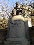 |
Key
The scheme for classifying buildings in Scotland is:
- Category A: "buildings of national or international importance, either architectural or historic; or fine, little-altered examples of some particular period, style or building type."[1]
- Category B: "buildings of regional or more than local importance; or major examples of some particular period, style or building type, which may have been altered."[1]
- Category C: "buildings of local importance; lesser examples of any period, style, or building type, as originally constructed or moderately altered; and simple traditional buildings which group well with other listed buildings."[1]
In March 2016 there were 47,288 listed buildings in Scotland. Of these, 8 per cent were Category A, and 50 per cent were Category B, with the rest listed at Category C.[2]
Notes
- ↑ Sometimes known as OSGB36, the grid reference (where provided) is based on the British national grid reference system used by the Ordnance Survey.
• "Guide to National Grid". Ordnance Survey. Retrieved 2007-12-12.
• "Get-a-map". Ordnance Survey. Retrieved 2007-12-17. - ↑ The "HB Number" is a unique number assigned to each listed building by Historic Environment Scotland.
References
- All entries, addresses and coordinates are based on data from Historic Scotland. This data falls under the Open Government Licence
- 1 2 3 "What is Listing?". Historic Environment Scotland. Retrieved 29 May 2018.
- ↑ Scotland's Historic Environment Audit 2016 (PDF). Historic Environment Scotland and the Built Environment Forum Scotland. pp. 15–16. Retrieved 29 May 2018.
This article is issued from
Wikipedia.
The text is licensed under Creative Commons - Attribution - Sharealike.
Additional terms may apply for the media files.