Rowe Street station
Rowe Street | |||||||||||||||||||||||||
|---|---|---|---|---|---|---|---|---|---|---|---|---|---|---|---|---|---|---|---|---|---|---|---|---|---|
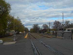 The abandoned Rowe Street station facing eastbound towards Belwood Park in April 2014. | |||||||||||||||||||||||||
| Location | Rowe Street at dead-end in Bloomfield, New Jersey | ||||||||||||||||||||||||
| Owned by | Norfolk Southern | ||||||||||||||||||||||||
| Line(s) | |||||||||||||||||||||||||
| Platforms | 2 ground-level | ||||||||||||||||||||||||
| Tracks | 2 | ||||||||||||||||||||||||
| Construction | |||||||||||||||||||||||||
| Platform levels | 1 | ||||||||||||||||||||||||
| History | |||||||||||||||||||||||||
| Opened | 1955[1] | ||||||||||||||||||||||||
| Closed | September 20, 2002[2] | ||||||||||||||||||||||||
| Services | |||||||||||||||||||||||||
| |||||||||||||||||||||||||
Rowe Street is an abandoned train station in the town of Bloomfield, New Jersey. The station was a former stop on the Boonton Line, which ran from Hoboken Terminal to Hackettstown, reaching Rowe Street in Bloomfield. The station was constructed by the Erie Railroad in 1955 as a replacement for the Orchard Street station and the former Bloomfield station (at Walnut Street), which was eliminated for construction of the Garden State Parkway. Construction of the new depot began on April 1, 1955 of a 17 by 45 feet (5.2 m × 13.7 m) single-story brick building. The construction of the depot and the 26-space parking lot cost $23,000 (1955 USD).[3]
Service to Rowe Street lasted for 47 years, until the construction of the Montclair Connection was completed by New Jersey Transit, who had taken over service in 1983. Rowe Street, along with nearby Benson Street (in Glen Ridge) and Arlington (in Kearny), were closed on October 20, 2002 for the new Montclair-Boonton Line.[2]
History
Orchard Street station
The establishment of a new depot at Orchard Street along the New York and Greenwood Lake Railway began in 1891. The city committee for constructing a new station announced that plans were out in September 1891 for a new station. They also announced the Erie Railroad, the company which owned the line, would accept a new station when constructed. They would also staff it with an agent.[4] On March 23, 1892, a benefit fundraiser occurred for funding the new depot. Tickets would be 25 cents (1892 USD) to attend as they would collect donations and gifts for the cause. By doing this, they would offer the gifts off to raffle to attendees. The plot for the new station was to cost $4,000, located at the intersection of Orchard, Smith and Baylis Streets.[5] The fundraiser raised $127.[6]
In the August 13, 1892 edition of The Bloomfield Citizen newspaper, the station was completed by that date. The Erie promised a new station agent would have been stationed on August 1. However, by August 13, the station was closed still with no agent.[7] On September 1, 1892, the Erie appointed William H. Flood as ticket agent for the Orchard Street station. The railroad superintendent, Moodey, announced that tickets would be available starting the week after.[8]
The new station proved to be a boon for the community, and considered convenient by local commuters.[9] Development was quick in the area around the new station.[10]
References
- ↑ Yanosey, Robert J. (2006). Erie Railroad Facilities (In Color). 1. Scotch Plains, New Jersey: Morning Sun Books Inc. p. 69. ISBN 1-58248-183-0.
- 1 2 "Rail Shuttle Buses To Transport Commuters Affected By Station Closures". Newark, New Jersey: New Jersey Transit. August 27, 2002. Retrieved 24 November 2009.
- ↑ "Plans Filed For New Erie Station". The Independent Press. March 17, 1955. p. 3. Retrieved June 9, 2017.
- ↑ "Brief Notes". The Bloomfield Citizen. September 5, 1891. Retrieved February 12, 2018.
- ↑ "Oakland Notes". The Bloomfield Citizen. March 12, 1892. p. 5. Retrieved February 12, 2018.
- ↑ "Local Jottings". The Bloomfield Citizen. April 2, 1892. p. 5. Retrieved February 12, 2018.
- ↑ "Local Jottings". The Bloomfield Citizen. August 13, 1892. p. 5. Retrieved February 12, 2018.
- ↑ "Local Jottings". The Bloomfield Citizen. September 3, 1892. p. 5. Retrieved February 12, 2018.
- ↑ "Bloomfield Affairs". The Bloomfield Citizen. May 24, 1892. p. 9. Retrieved February 12, 2018.
- ↑ "Local Jottings". The Bloomfield Citizen. October 22, 1892. p. 8. Retrieved February 12, 2018.