Rope, Cheshire
| Rope | |
|---|---|
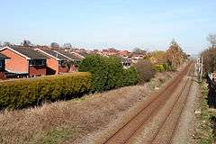 Crewe to Nantwich railway from Ropegreen Bridge; Wells Green is on the left | |
 Rope Rope shown within Cheshire | |
| Population | 2,034 (2011) |
| OS grid reference | SJ690528 |
| Civil parish |
|
| Unitary authority | |
| Ceremonial county | |
| Region | |
| Country | England |
| Sovereign state | United Kingdom |
| Post town | CREWE |
| Postcode district | CW2 |
| Dialling code | 01270 |
| Police | Cheshire |
| Fire | Cheshire |
| Ambulance | North West |
| EU Parliament | North West England |
| UK Parliament | |
Rope is a scattered settlement and civil parish in the unitary authority of Cheshire East and the ceremonial county of Cheshire, England. It lies immediately to the south of Crewe, with the centre of the parish being around 2¼ miles from the centre of Crewe. Nearby villages include Shavington, Willaston and Wistaston. The civil parish has a total population of just over 2150, reducing to 2,034 at the 2011 Census.[1]
Governance
Rope is administered by Rope Parish Council.[2] Cllr. Brian Silvester, who is on the parish council, is the first councillor to represent the far-right party, For Britain. From 1974 the civil parish was served by Crewe and Nantwich Borough Council, which was succeeded on 1 April 2009 by the new unitary authority of Cheshire East .[3] Rope falls in the parliamentary constituency of Crewe and Nantwich,[4] which has been represented by Edward Timpson since a by-election in 2008.
Geography and transport

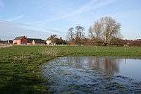
Much of the area is relatively flat, with an average elevation of around 50 metres. Urban development is largely limited to the Wells Green area in north east corner of the civil parish, adjacent to Wistaston and south Crewe. Much of the remainder of the parish is rural, with the major land use being agricultural. Wellsgreen Brook and Swill Brook run through the east of the civil parish; the latter forms part of its eastern boundary. There are several other unnamed brooks within the parish, as well as several small meres and ponds.[5][6]
The Crewe–Nantwich railway line runs east–west through the centre of the parish. The A500 trunk road runs around 500 metres south of the railway line, in the south of the parish. Rope Lane runs north–south through the parish, crossing the railway line at Ropegreen Bridge; it connects Crewe and Shavington. Gresty Lane/Eastern Road runs east–west through the parish immediately south of the railway, and connects Willaston with the B5071 north of Shavington.[5][6]
Demography
According to the 2001 census, the civil parish had a population of 2155 in 778 households.[7] The historical population figures were 79 (1801), 96 (1851), 62 (1901) and 177 (1951).[8]
Education
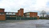
Shavington Academy, located on Rope Lane at SJ694523, provides secondary education for Rope and civil parishes to the south of Crewe.[9][10] Berkeley Primary School, at SJ695531, provides primary education for the northern half of the civil parish, as well as parts of Wistaston and Shavington cum Gresty. The southern half of the parish falls within the catchment area of Shavington Primary School in Shavington.[11]
References
- ↑ "Civil Parish population 2011". Neighbourhood Statistics. Office for National Statistics. Retrieved 15 March 2016.
- ↑ Cheshire County Council: Parish Council Details: Rope Parish Council (accessed 29 January 2009)
- ↑ Cheshire (Structural Changes) Order 2008
- ↑ Cheshire County Council: Interactive Mapping: Crewe and Nantwich (accessed 27 January 2009)
- 1 2 Cheshire County Council: Interactive Mapping: Rope (accessed 29 January 2009)
- 1 2 Ordnance Survey Explorer Map 257: Crewe & Nantwich
- ↑ Neighbourhood Statistics: Rope CP (accessed 29 January 2009)
- ↑ Genuki: Rope (accessed 29 January 2009)
- ↑ Cheshire County Council: Interactive Mapping: Shavington High School (accessed 29 January 2009)
- ↑ Geograph: Shavington High School, Rope (accessed 14 August 2007)
- ↑ Cheshire County Council: Interactive Mapping: Primary School Catchment Areas (accessed 29 January 2009)
External links
![]()
Cheshire Portal | |
| Unitary authorities | |
| Major settlements | |
| Rivers | |
| Topics | |