Rocky Ridge, Utah
| Town of Rocky Ridge, Utah | |
|---|---|
| Town | |
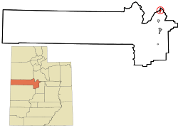 Location of Rocky Ridge within Juab County and the State of Utah. | |
| Coordinates: 39°55′30″N 111°49′35″W / 39.92500°N 111.82639°WCoordinates: 39°55′30″N 111°49′35″W / 39.92500°N 111.82639°W | |
| Country | United States |
| State | Utah |
| County | Juab |
| Incorporated | January 1, 1998 |
| Area | |
| • Total | 1.9 sq mi (4.9 km2) |
| • Land | 1.9 sq mi (4.9 km2) |
| • Water | 0.0 sq mi (0.0 km2) |
| Elevation | 4,990 ft (1,521 m) |
| Population (2012) | |
| • Total | 744 |
| • Density | 214.9/sq mi (83.0/km2) |
| Time zone | UTC-7 (Mountain (MST)) |
| • Summer (DST) | UTC-6 (MDT) |
| FIPS code | 49-64590[1] |
| GNIS feature ID | 2412568[2] |
| Website |
www |
Town of Rocky Ridge is a town on the northeastern edge of Juab County, Utah, United States.[2][3]
Description
The town is located on the northern edge of Juab Valley in the eastern foothills of , but entirely west of Interstate 15 (I‑15).[4] It is part of the Provo–Orem, Utah Metropolitan Statistical Area. The population was 733 at the 2010 census.[5]
While there is a "Rocky Ridge"[6] and a "Rocky Ridge Canyon"[7] with in northeastern Juab County (both located east of the city of Nephi, approximately 16 miles [26 km] south‑southeast of the community), according to the town's website, the town was named general for "the rocks, in a bountiful array of types and colors, strewn plentifully across the surrounding ridges separating Juab and Utah Counties."[8]
History
The original community in the area was known as York and was the southern terminus of the Utah Southern Railroad from February 1875 to May 1979.[8] (The Utah Southern Railroad was controlled by the Union Pacific Railroad.)[9] However, after the railroad was extended further south, the community of York was essentially abandoned.[8][10] A post office had been established in the community in 1875, but it closed in 1879.[11]
Nearly a century passed without much change, but by 1971 Marvin L. Allred had purchased 225 acres (91 ha) in the area and I‑15 had been completed to just north of the Juab‑Utah county line. Over the next quarter century the community (which had become known as locally as Allred Ranch)[12] continued growing, with the completion of I‑15 through the valley and the addition of more than 950 acres (380 ha) to the community.[8]
In May 1996, the Juab County Commissioners received a petition to incorporate the area under the name Rocky Ridge. (A few year prior some residents of the area had petitioned unsuccessfully for incorporation under the name York.) The later petition indicated that the population of the area had reached 210.[12] By October of that year, the petition for incorporation was approved.[13]
Geography
According to the United States Census Bureau, the town has a total area of 1.9 square miles (4.9 km2), all of it land.
Demographics
| Historical population | |||
|---|---|---|---|
| Census | Pop. | %± | |
| 2000 | 403 | — | |
| 2010 | 733 | 81.9% | |
| Est. 2016 | 806 | [14] | 10.0% |
| U.S. Decennial Census[5] | |||
As of the census[1] of 2000, there were 403 people, 61 households, and 60 families residing in the town. The population density was 214.9 people per square mile (82.8/km2). There were 73 housing units at an average density of 38.9 per square mile (15.0/km2). The racial makeup of the town was 99.26% White, 0.25% from other races, and 0.50% from two or more races. Hispanic or Latino of any race were 1.24% of the population.
There were 61 households out of which 85.2% had children under the age of 18 living with them, 47.5% were married couples living together, 49.2% had a female householder with no husband present, and 1.6% were non-families. No households were made up of individuals and none had someone living alone who was 65 years of age or older. The average household size was 6.61 and the average family size was 6.53.
In the town, the population was spread out with 59.6% under the age of 18, 16.4% from 18 to 24, 16.9% from 25 to 44, 6.0% from 45 to 64, and 1.2% who were 65 years of age or older. The median age was 14 years. For every 100 females, there were 91.9 males. For every 100 females age 18 and over, there were 77.2 males.
The median income for a household in the town was $31,944, and the median income for a family was $31,944. Males had a median income of $25,536 versus $25,179 for females. The per capita income for the town was $6,180. About 25.0% of families and 18.5% of the population were below the poverty line, including 27.2% of those under age 18 and none of those age 65 or over.
Religion
The majority of the residents of Rocky Ridge are members of the Apostolic United Brethren.[15][16]
See also
References
- 1 2 "American FactFinder". factfincer2.census.gov. United States Census Bureau. Retrieved 31 Jan 2008.
- 1 2 "Rocky Ridge". Geographic Names Information System. United States Geological Survey.
- ↑ Google (23 Feb 2018). "Rocky Ridge, Utah" (Map). Google Maps. Google. Retrieved 23 Feb 2018.
- ↑ "MyTopo Maps - Rocky Ridge Town, UT, USA" (Map). mytopo.com. Trimble Navigation, Ltd. Retrieved 22 Feb 2018. Note: While the town is not labeled on the map, the search for "Rocky Ridge Town, UT, USA" centers on the location of the town.
- 1 2 "Census of Population and Housing". Census.gov. Retrieved 4 Jun 2015.
- ↑ "Rocky Ridge". Geographic Names Information System. United States Geological Survey.
- ↑ "Rocky Ridge Canyon". Geographic Names Information System. United States Geological Survey.
- 1 2 3 4 "About Us". rockyridgetown.com. Retrieved 23 Feb 2018.
- ↑ Strack, Don (17 Feb 2018). "Utah Southern Railroad (1870-1881) Utah Southern Railroad Extension (1879-1881)". utahrails.net. Retrieved 23 Feb 2018.
- ↑ Van Cott, John W. (1990). Utah Place Names: A Comprehensive Guide to the Origins of Geographic Names: A Compilation. Salt Lake City: University of Utah Press. p. 408. ISBN 978-0-87480-345-7. OCLC 797284427.
- ↑ Forte, Jim. "Post Offices: Utah: Juab". postalhistory.com. Retrieved 23 Feb 2018.
- 1 2 "Newest Town in East Juab May become Rocky Ridge". Deseret News. Salt Lake City: Deseret Digital Media. 24 May 1996. Retrieved 23 Feb 2018.
- ↑ "New Town of Rocky Ridge Wins Juab County Approval". Deseret News. Salt Lake City: Deseret Digital Media. 31 Oct 1996. Retrieved 23 Feb 2018.
- ↑ "Population and Housing Unit Estimates". Retrieved 9 Jun 2017.
- ↑ "The Apostolic United Brethren (Allred Group)". mormonfundamentalism.com. Archived from the original on 4 Feb 2016. Retrieved 23 Feb 2018 – via web.archive.org.
- ↑ The Primer: Helping Victims of Domestic Violence and Child Abuse in Polygamous Communities (PDF) (Report). Utah Attorney General. 2005. pp. 17–18. Retrieved 23 Feb 2018.
External links
| Wikimedia Commons has media related to Rocky Ridge, Utah. |
Places adjacent to Rocky Ridge, Utah | ||||||||||
|---|---|---|---|---|---|---|---|---|---|---|
| ||||||||||
Municipalities and communities of Juab County, Utah, United States | ||
|---|---|---|
| Cities |  | |
| Towns | ||
| Unincorporated communities | ||
| Ghost towns | ||
| Indian reservation | ||
| Footnotes | ‡This populated place also has portions in an adjacent county or counties | |