Genola, Utah
| Genola | |
|---|---|
| Town | |
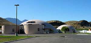 Centro de la Familia de Utah Migrant Head Start Center in Genola | |
 Location in Utah County and the State of Utah | |
| Coordinates: 39°59′35″N 111°50′11″W / 39.99306°N 111.83639°WCoordinates: 39°59′35″N 111°50′11″W / 39.99306°N 111.83639°W | |
| Country | United States |
| State | Utah |
| County | Utah County |
| Incorporated | December 29, 1935 |
| Area | |
| • Total | 13.9 sq mi (35.9 km2) |
| • Land | 13.4 sq mi (34.8 km2) |
| • Water | 0.4 sq mi (1.1 km2) |
| Elevation | 4,600 ft (1,402 m) |
| Population (2012) | |
| • Total | 1,390 |
| • Density | 100/sq mi (39/km2) |
| Time zone | UTC-7 (Mountain (MST)) |
| • Summer (DST) | UTC-6 (MDT) |
| ZIP code | 84655 |
| Area code(s) | 385, 801 |
| FIPS code | 49-28810[1] |
| GNIS feature ID | 1441295[2] |
| Website |
genola |
Genola (/dʒəˈnoʊlə/ jə-NOH-lə) is a town in Utah County, Utah, United States. It is part of the Provo–Orem Metropolitan Statistical Area. The population was 1,370 at the 2010 census.[3]
Geography
According to the United States Census Bureau, the town has a total area of 13.9 square miles (35.9 km2), of which 13.4 square miles (34.8 km2) is land and 0.42 square miles (1.1 km2), or 3.10%, is water.[4]
The town is located in northeast Goshen Valley; Santaquin is adjacent to the southeast. The former area of Townsend is located within the southeast area of Genola.
Demographics
| Historical population | |||
|---|---|---|---|
| Census | Pop. | %± | |
| 1920 | 194 | — | |
| 1930 | 321 | 65.5% | |
| 1940 | 325 | 1.2% | |
| 1950 | 314 | −3.4% | |
| 1960 | 380 | 21.0% | |
| 1970 | 424 | 11.6% | |
| 1980 | 630 | 48.6% | |
| 1990 | 803 | 27.5% | |
| 2000 | 965 | 20.2% | |
| 2010 | 1,370 | 42.0% | |
| Est. 2016 | 1,484 | [5] | 8.3% |
| Source: U.S. Census Bureau[6] | |||
As of the census[1] of 2000, there were 965 people, 224 households, and 196 families residing in the town. The population density was 75.7 people per square mile (29.2/km²). There were 242 housing units at an average density of 19.0 per square mile (7.3/km²). The racial makeup of the town was 92.54% White, 0.73% Native American, 0.41% Asian, 5.39% from other races, and 0.93% from two or more races. Hispanic or Latino of any race were 8.08% of the population.
There were 224 households out of which 59.4% had children under the age of 18 living with them, 79.9% were married couples living together, 6.3% had a female householder with no husband present, and 12.1% were non-families. 11.2% of all households were made up of individuals and 7.6% had someone living alone who was 65 years of age or older. The average household size was 4.18 and the average family size was 4.55.
In the town, the population was spread out with 44.4% under the age of 18, 9.0% from 18 to 24, 21.6% from 25 to 44, 16.9% from 45 to 64, and 8.2% who were 65 years of age or older. The median age was 22 years. For every 100 females, there were 115.9 males. For every 100 females age 18 and over, there were 115.7 males.
The median income for a household in the town was $45,417, and the median income for a family was $50,125. Males had a median income of $31,563 versus $25,833 for females. The per capita income for the town was $13,484. About 4.4% of families and 9.9% of the population were below the poverty line, including 12.1% of those under age 18 and 2.5% of those age 65 or over.
See also
References
- 1 2 "American FactFinder". factfinder2.census.gov. United States Census Bureau. Archived from the original on 2013-09-11. Retrieved 2008-01-31.
- ↑ "US Board on Geographic Names". geonames.usgs.gov. United States Geological Survey. 25 Oct 2007. Retrieved 31 Jan 2008.
- ↑ "Profile of General Population and Housing Characteristics: 2010 Demographic Profile Data (DP-1): Genola town, Utah". census.gov. United States Census Bureau, American Factfinder. Archived from the original on 2013-09-11. Retrieved 8 Mar 2012.
- ↑ "Geographic Identifiers: 2010 Demographic Profile Data (G001): Genola town, Utah". census.gov. United States Census Bureau, American Factfinder. Archived from the original on 2013-09-11. Retrieved 8 Mar 2012.
- ↑ "Population and Housing Unit Estimates". Retrieved June 9, 2017.
- ↑ "Census of Population and Housing". census.gov. United States Census Bureau. Archived from the original on 8 February 2006. Retrieved 18 Nov 2011.
External links
| Wikimedia Commons has media related to Genola, Utah. |
- Town of Genola (official website)
Places adjacent to Genola, Utah | |
|---|---|
Municipalities and communities of Utah County, Utah, United States | ||
|---|---|---|
| Cities | 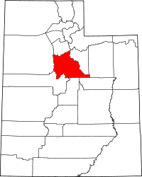 | |
| Towns | ||
| CDPs | ||
| Unincorporated communities | ||
| Indian reservation | ||
| Ghost towns | ||
| Footnotes | ‡This populated place also has portions in an adjacent county or counties | |