Rivière-Beaudette, Quebec
| Rivière-Beaudette | |
|---|---|
| Municipality | |
 | |
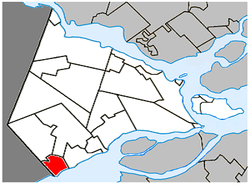 Location within Vaudreuil-Soulanges RCM. | |
 Rivière-Beaudette Location in southern Quebec. | |
| Coordinates: 45°14′N 74°20′W / 45.233°N 74.333°WCoordinates: 45°14′N 74°20′W / 45.233°N 74.333°W[1] | |
| Country |
|
| Province |
|
| Region | Montérégie |
| RCM | Vaudreuil-Soulanges |
| Constituted | January 17, 1990 |
| Government[2][3] | |
| • Mayor | Patrick Bousez |
| • Federal riding | Salaberry—Suroît |
| • Prov. riding | Soulanges |
| Area[2][4] | |
| • Total | 25.30 km2 (9.77 sq mi) |
| • Land | 18.51 km2 (7.15 sq mi) |
| Population (2011)[4] | |
| • Total | 1,885 |
| • Density | 101.9/km2 (264/sq mi) |
| • Pop 2006-2011 |
|
| • Dwellings | 894 |
| Time zone | UTC−5 (EST) |
| • Summer (DST) | UTC−4 (EDT) |
| Postal code(s) | J0P 1R0 |
| Area code(s) | 450 and 579 |
| Highways |
|
| Website |
www |
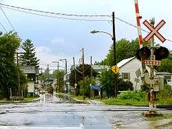
Rivière-Beaudette is a municipality of Quebec, Canada, located in the southwest corner of the Vaudreuil-Soulanges Regional County Municipality on the border with Ontario along the Saint Lawrence River. The population as of the Canada 2011 Census was 1,885.
The area is primarily made up of farmland with residential development along the St. Lawrence River.
Demographics
Population
| Canada census – Rivière-Beaudette, Quebec community profile | |||
|---|---|---|---|
| 2011 | 2006 | ||
| Population: | 1,885 (+9.6% from 2006) | 1,720 (+17.5% from 2001) | |
| Land area: | 18.51 km2 (7.15 sq mi) | 18.47 km2 (7.13 sq mi) | |
| Population density: | 101.9/km2 (264/sq mi) | 93.1/km2 (241/sq mi) | |
| Median age: | 43.5 (M: 44.3, F: 41.8) | 43.2 (M: 43.8, F: 42.9) | |
| Total private dwellings: | 894 | 814 | |
| Median household income: | $63,336 | $40,777 | |
| References: 2011[4] 2006[5] earlier[6] | |||
| Historical Census Data - Rivière-Beaudette, Quebec[7] | ||||||||||||||||||||||||||
|---|---|---|---|---|---|---|---|---|---|---|---|---|---|---|---|---|---|---|---|---|---|---|---|---|---|---|
|
|
| ||||||||||||||||||||||||
Language
| Canada Census Mother Tongue - Rivière-Beaudette, Quebec[7] | ||||||||||||||||||
|---|---|---|---|---|---|---|---|---|---|---|---|---|---|---|---|---|---|---|
| Census | Total | French |
English |
French & English |
Other | |||||||||||||
| Year | Responses | Count | Trend | Pop % | Count | Trend | Pop % | Count | Trend | Pop % | Count | Trend | Pop % | |||||
2011 |
1,860 |
1,600 | 86.02% | 170 | 9.14% | 30 | 1.61% | 60 | 3.23% | |||||||||
2006 |
1,695 |
1,480 | 87.32% | 190 | 11.21% | 0 | 0.00% | 25 | 1.47% | |||||||||
2001 |
1,440 |
1,340 | 93.06% | 85 | 5.90% | 15 | 1.04% | 0 | 0.00% | |||||||||
1996 |
1,350 |
1,150 | n/a | 85.19% | 150 | n/a | 11.1% | 20 | n/a | 1.48% | 30 | n/a | 2.22% | |||||
Education
Commission Scolaire des Trois-Lacs operates Francophone schools.[8]
Lester B. Pearson School Board operates Anglophone schools.[9]
- Soulanges Elementary School in Saint-Télesphore or Evergreen Elementary and Forest Hill Elementary (Junior Campus and Senior campus) in Saint-Lazare
See also
References
- ↑ Reference number 248141 of the Commission de toponymie du Québec (in French)
- 1 2 Ministère des Affaires municipales, des Régions et de l'Occupation du territoire: Rivière-Beaudette
- ↑ Parliament of Canada Federal Riding History: VAUDREUIL--SOULANGES (Quebec)
- 1 2 3 "2011 Community Profiles". Canada 2011 Census. Statistics Canada. July 5, 2013. Retrieved 2014-02-07.
- ↑ "2006 Community Profiles". Canada 2006 Census. Statistics Canada. March 30, 2011. Retrieved 2014-02-07.
- ↑ "2001 Community Profiles". Canada 2001 Census. Statistics Canada. February 17, 2012.
- 1 2 Statistics Canada: 1996, 2001, 2006, 2011 census
- ↑ "Les écoles et les centres". Commission Scolaire des Trois-Lacs. Retrieved 18 January 2013.
- ↑ "School Board Map." Lester B. Pearson School Board. Retrieved on September 28, 2017.
Adjacent Municipal Subdivisions | |
|---|---|
| Cities & towns | |
|---|---|
| Municipalities | |
| Villages | |
| |
This article is issued from
Wikipedia.
The text is licensed under Creative Commons - Attribution - Sharealike.
Additional terms may apply for the media files.