Min River (Fujian)
 | |
.svg.png) | |
| Native name | (simplified Chinese: 闽江; traditional Chinese: 閩江; pinyin: Mǐn Jiāng) |
|---|---|
| Physical characteristics | |
| River mouth | East China Sea |
| Length | 577 km (359 mi) |
| Discharge |
|
| Basin features | |
| Basin size | 60,922 km2 (23,522 sq mi) |
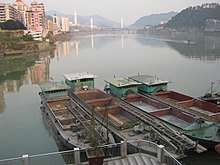
Min River (闽江)in Nanping (南平). Railway bridge (闽江铁路大桥) at the back.
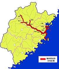
The Min River (simplified Chinese: 闽江; traditional Chinese: 閩江; pinyin: Mǐn Jiāng; Foochow Romanized: Mìng-gĕ̤ng) is a 577 kilometres (359 mi)-long river in Fujian province, People's Republic of China. It is the largest river in Fujian, and an important water transport channel. Most of northern and central Fujian is within its drainage area.
The provincial capital, Fuzhou, sits on the lower Min River, with its historic center being on the northern side of the river,even closer to its fall into the East China Sea; the location historically made it an important port.
See also
| Wikimedia Commons has media related to Min River (Fujian). |
- List of rivers in China
- Min River (disambiguation) - for other rivers with the same name
References
This article is issued from
Wikipedia.
The text is licensed under Creative Commons - Attribution - Sharealike.
Additional terms may apply for the media files.