River Bain, North Yorkshire
| River Bain | |
|---|---|
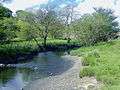
 River Bain near Countersett | |
| Country | England |
| Physical characteristics | |
| Main source |
Semerwater 252 metres (827 ft) 54°17′3″N 2°7′22″W / 54.28417°N 2.12278°W |
| River mouth |
River Ure (at Bainbridge) 54°18′45″N 2°6′3″W / 54.31250°N 2.10083°WCoordinates: 54°18′45″N 2°6′3″W / 54.31250°N 2.10083°W |
| Length | 3.95 kilometres (2.45 mi) |
The River Bain is a river in North Yorkshire, England. As a tributary of the River Ure, it is one of the shortest, named rivers in England.[1] The river is home to the small scale hydroelectricity project River Bain Hydro located at Bainbridge.[2]
Course
The river leaves the second-largest natural lake in North Yorkshire, Semerwater, in a north-east direction past the hamlet of Countersett.[3] After a couple of gentle meanders it runs though woodland before slowly turning northward. It passes under the A684 road in Bainbridge and joins the River Ure to the east of Yore Bridge opposite the mouth of Grange Beck.
Images
 River Bain leaving Semerwater
Sources
| Wikimedia Commons has media related to River Bain, North Yorkshire. |
References
- ↑ Winn, Christopher (2010). I never knew that about Yorkshire. London: Ebury. p. 105. ISBN 978-0-09-193313-5.
- ↑ "Official switch on for river Bain hydro". Resonance Limited. 17 May 2011. Retrieved 13 February 2012.
- ↑ "Semerwater". Retrieved 27 February 2011.
This article is issued from
Wikipedia.
The text is licensed under Creative Commons - Attribution - Sharealike.
Additional terms may apply for the media files.