Risedale Beck
Risedale Beck is a small river that rises on Hipswell Moor, near Catterick Garrison in North Yorkshire, England. It flows eastwards into Catterick Garrison as Leadmill Gill, (also known as Cottages Beck)[1] which in turn flows into Colburn Beck, a tributary of the River Swale.[2] The length of the beck from source to the River Swale is 6.5 miles (10.4 km).[3]
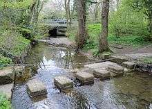
As the beck passes through Catterick Garrison, its northern bank forms the edge of Foxglove Covert, a nationally acclaimed nature reserve on military land.[4] Otters have been noted at the covert and they were filmed fishing on the beck.[5]
In June 2007, the area suffered 2-months worth of rain in 48 hours. This led to the beck being swollen from what is normally a trickle to waist deep water. A British Army infantry course on their final 8 mi (13 km) fitness test forded the beck. One private was swept away to his death.[6]
References
- ↑ "SE 19" (Map). Catterick Camp. 1:25,000. Ordnance Survey. 1952. Retrieved 10 August 2017.
- ↑ "302" (Map). Northallerton & Thirsk (C1 ed.). 1:25,000. Explorer. Ordnance Survey. 2014. ISBN 9780319245545.
- ↑ "Colburn Beck/Risedale Bk from Source to R Swale". environment.data.gov.uk. Environment Agency. Retrieved 5 March 2017.
- ↑ "Anger at Foxglove Covert nature reserve plans to force visitors to cross Army training area". The Northern Echo. 2 February 2014. Retrieved 5 March 2017.
- ↑ "Otters on Risedale Beck". www.foxglovecovert.org.uk. 19 January 2015. Retrieved 5 March 2017.
- ↑ Foster, Mark (25 November 2008). "Team misjudged danger of flooded beck – inquest". The Northern Echo. Retrieved 5 March 2017.
Coordinates: 54°23′28″N 1°42′40″W / 54.391°N 1.711°W