Bedale Beck
| Bedale Beck | |
| Burton Beck Crakehall Beck Leeming Beck Newton Beck | |
| River | |
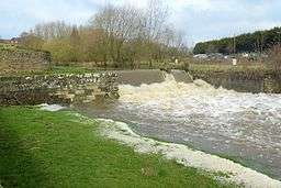 The Harbour at Bedale | |
| Country | England |
|---|---|
| State | North Yorkshire |
| District | Hambleton District |
| Part of | River Swale |
| Length | 25.7 mi (41 km) |
Bedale Beck is a river that flows through the eastern end of Wensleydale and passes through Crakehall, Bedale and Leeming before entering the River Swale at a point between Morton-on-Swale and Gatenby. Between source and mouth its length is 25.7 miles (41 km).[1][2][3]
Route
The beck begins at Constable Burton with the confluence of three becks (Bellerby & Burton, Whipperdale and a third un-named beck). These all rise in the upland north of Leyburn, with Bellerby Beck spilling off of the moor above the hamlet of Bellerby. At Constable Burton it flows under the A684 road and between there and Patrick Brompton it is listed on mapping as being called, Burton Beck, Leeming Beck and Newton Beck. At Crakehall it is also named Crakehall Beck.[4]
It takes on the name Bedale Beck proper just east of Crakehall before flowing south under the new A684 bypass and into the town of Bedale where it forms the boundary between the civil parishes of Aiskew and Bedale. After Bedale it flows east then north, going under the A6055 road and the A1(M) before changing direction and going east along the northern edge of RAF Leeming. It joins the River Swale between Morton-on-Swale and Gatenby.[5]
History
The beck was the location for water mills with at least two being recorded in the Bedale area by 1297.[6] The most famous of these is the mill which is still extant at Crakehall. This mill was renovated in 1980 and again in the new millennium and grinds corn on special open days.[7] Both of the mills at Aiskew and Crakehall had millraces constructed for them with Crakehall's still there and transporting water. The mill at Aiskew had closed down but was re-opened in 2010 as a community bakery.[8]
In the 18th century, an attempt was made to make the beck navigable from Bedale to the River Swale. This plan was abandoned due to a lack of investment and in 1855 the railway was opened which superseded the plans for a canal.[9] It did result in a weir and sluice gate in Bedale that is still known today as 'The Harbour'.[10] This was part of a grander plan to convert the Swale into a navigation from the River Ure up to Bedale. This plan also involved installing a lock just west of Leeming village which was known as Leeming Lock. The lock survived until the Second World War when it was blown up, though no-one knows if this was deliberate or accidental.[11] This also meant having to divert the watercourse that flows past Floodbridge Farm and which now joins Bedale Beck further downstream than where it used to.[10]
As with other watercourses, flooding on the beck has led to problems. In 1901, floodwaters undermined the trackbed of the railway line west of Bedale causing a locomotive to derail and killing its fireman.[12]
Ecology
The beck, along with others that feed into the River Swale in Hambleton, has been identified as having poor ecological[13] quality and having too much sediment entering the water. Too much sediment impedes the habitat for fish, elevates phosphate levels and contributes to flooding.[14]
Both Bedale and Leeming have been identified as being the main receptors of flooding along the beck due to their low lying and flat nature (especially between Bedale and Leeming which has been described as a 'level floodplain')[15] in comparison to the rest of the beck's course.[16]
References
- ↑ "Bedale/Newton/Burton Bk from Source to Brompton Bk". environment.data.gov.uk. Environment Agency. Retrieved 27 March 2017.
- ↑ "Bedale/Newton/Burton Bk - Brompton Bk to Rand". environment.data.gov.uk. Environment Agency. Retrieved 27 March 2017.
- ↑ "Bedale/Newton/Burton Bk from Rand Bk to R Swale". environment.data.gov.uk. Retrieved 27 March 2017.
- ↑ "OL 30" (Map). Yorkshire dales Northern & Central Area (Wensleydale & Swaledale). 1:25,000. Explorer. Ordnance Survey. 2016. ISBN 9780319263358.
- ↑ "302" (Map). Northallerton & Thirsk. 1:25,000. Explorer. Ordnance Survey. 2016. ISBN 9780319245545.
- ↑ "A684 Bedale - Aiskew - Leeming Bar Bypass" (PDF). archaeologydataservice.ac.uk. North Yorkshire County Council. November 2009. p. 19. Retrieved 27 March 2017.
- ↑ "Watermill". Crakehall Watermill. 1 August 2011. Retrieved 27 March 2017.
- ↑ Gleeson, Janet (8 April 2014). "Bedale bakery bowled over after bringing bread to market". The Northern Echo. Retrieved 27 March 2017.
- ↑ Fletcher, Terry. "Explore Bedale, a stronghold of independence with a cherished Georgian style". Yorkshire Life. Retrieved 27 March 2017.
- 1 2 "How a lack of cash scuppered an engineering project of the canal age". Darlington and Stockton Times. 13 November 2009. Retrieved 27 March 2017.
- ↑ Reynolds, Simon (2001). A chronicle of Bedale (1 ed.). St Gregory's Publications. p. 16. ISBN 0-9540558-0-2.
- ↑ Jenkins, Stanley C. (2002). The Wensleydale branch : a new history (2 ed.). Usk: Oakwood. p. 99. ISBN 0-85361-587-X.
- ↑ "Trust volunteers busy on walkover surveys" (PDF). yorkshiredalesrivertrust.com. Spring 2015. p. 7. Retrieved 27 March 2017.
- ↑ "Middle Swale Tributaries - Yorkshire Dales Rivers Trust". Yorkshire Dales Rivers Trust. Retrieved 27 March 2017.
- ↑ "A684 Bedale - Aiskew - Leeming Bar Bypass" (PDF). archaeologydataservice.ac.uk. North Yorkshire County Council. November 2009. p. 25. Retrieved 27 March 2017.
- ↑ Hambleton, New Local Plan for (October 2016). "Hambleton Strategic Flood Risk Assessment (Oct 2016)" (PDF). www.hambleton.gov.uk. Hambleton District Council. p. 19. Retrieved 27 March 2017.