Richland Township, Whitley County, Indiana
| Richland Township | |
|---|---|
| Township | |
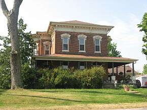 The Dr. Christopher Souder House in Larwill | |
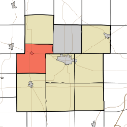 Location in Whitley County | |
| Coordinates: 41°09′25″N 85°36′55″W / 41.15694°N 85.61528°WCoordinates: 41°09′25″N 85°36′55″W / 41.15694°N 85.61528°W | |
| Country | United States |
| State | Indiana |
| County | Whitley |
| Government | |
| • Type | Indiana township |
| Area | |
| • Total | 37.19 sq mi (96.3 km2) |
| • Land | 37.05 sq mi (96.0 km2) |
| • Water | 0.14 sq mi (0.4 km2) 0.38% |
| Elevation[1] | 883 ft (269 m) |
| Population (2010) | |
| • Total | 1,758 |
| • Density | 47.4/sq mi (18.3/km2) |
| Time zone | UTC-5 (Eastern (EST)) |
| • Summer (DST) | UTC-4 (EDT) |
| Area code(s) | 260 |
| GNIS feature ID | 453801 |
Richland Township is one of nine townships in Whitley County, Indiana, United States. As of the 2010 census, its population was 1,758 and it contained 712 housing units.[2]
Geography
According to the 2010 census, the township has a total area of 37.19 square miles (96.3 km2), of which 37.05 square miles (96.0 km2) (or 99.62%) is land and 0.14 square miles (0.36 km2) (or 0.38%) is water.[2] Lakes in this township include Black Lake, Compton Lake, Ice House Lake, Larwill Lake, Little Wilson Lake, Menzie Lake, Souder Lake and Wilson Lake. The streams of Betzner Branch, Ford Branch, Jones Branch, Kaler Branch and King Branch run through this township.
Cities and towns
Adjacent townships
- Etna-Troy Township (north)
- Thorncreek Township (northeast)
- Columbia Township (east)
- Cleveland Township (south)
- Jackson Township, Kosciusko County (southwest)
- Monroe Township, Kosciusko County (west)
- Washington Township, Kosciusko County (northwest)
Cemeteries
The township contains two cemeteries: Lakeview and Richland Center.
Major highways
Education
Richland Township residents may obtain a free library card from the South Whitley Community Public Library.[3]
References
- ↑ "US Board on Geographic Names". United States Geological Survey. October 25, 2007. Retrieved 2017-05-08.
- 1 2 "Population, Housing Units, Area, and Density: 2010 - County -- County Subdivision and Place -- 2010 Census Summary File 1". United States Census. Retrieved 2013-05-10.
- ↑ "Circulation Policy". South Whitley Community Public Library. Retrieved 17 March 2018.
External links
Municipalities and communities of Whitley County, Indiana, United States | ||
|---|---|---|
| City | ||
| Towns | ||
| Townships | ||
| CDP | ||
| Other unincorporated communities | ||
| Footnotes | ‡This populated place also has portions in an adjacent county or counties | |