Regadera Formation
| Regadera Formation Stratigraphic range: Middle to Late Eocene ~49–40 Ma | |
|---|---|
| Type | Geological formation |
| Underlies | Usme Fm., Tilatá Fm. |
| Overlies | Bogotá Formation |
| Thickness | up to 756 metres (2,480 ft) |
| Lithology | |
| Primary | Sandstone, conglomerate |
| Other | Shale |
| Location | |
| Coordinates | 4°23′30.8″N 74°08′26.3″W / 4.391889°N 74.140639°WCoordinates: 4°23′30.8″N 74°08′26.3″W / 4.391889°N 74.140639°W |
| Region |
Bogotá savanna, Altiplano Cundiboyacense Eastern Ranges, Andes |
| Country |
|
| Type section | |
| Named for | La Regadera Reservoir |
| Named by | Julivert |
| Location | Usme, Bogotá |
| Year defined | 1963 |
| Coordinates | 4°23′30.8″N 74°08′26.3″W / 4.391889°N 74.140639°W |
| Region | Cundinamarca |
| Country |
|
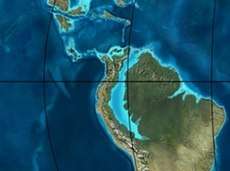 Paleogeography of Northern South America 50 Ma, by Ron Blakey | |
The Regadera Formation (Spanish: Formación Regadera, E2r, Tpr) is a geological formation of the Bogotá savanna, Altiplano Cundiboyacense, Eastern Ranges of the Colombian Andes. The predominantly sandstone and conglomeratic formation, with pink shale beds intercalated, dates to the Paleogene period; Middle to Late Eocene epoch, and has a maximum thickness of 765 metres (2,510 ft).
Etymology
The formation was first described by Hubach in 1931 as part of the Usme Formation and redefined and named in 1963 by Julivert after the La Regadera Reservoir.[1]
Description
Lithologies
The Regadera Formation consists mainly of quartz arenitic sandstone and conglomerates with some shale beds.[1][2]
Stratigraphy and depositional environment
The Regadera Formation overlies the Bogotá Formation and is overlain by the Usme and Tilatá Formations. The age has been estimated, based on palynological data of Echitriporites trianguliformis var. orbicularis, Nothofagidites sp. and Multiporopollenites pauciporatus, to be Middle to Late Eocene.[3] The depositional environment has been interpreted as a braided river setting.[4]
Outcrops
The Regadera Formation is apart from its type locality in the synclinal of Usme, the valley of the Tunjuelo River, found in the synclinal of Sisga.[1] In the Tunjuelo River valley, the Regadera Formations is present in the escarpments on the river banks.[5]
See also
References
Bibliography
- Bayona, Germán; Omar Montenegro; Agustín Cardona; Carlos Jaramillo; Felipe Lamus; Sara Morón; Luiz Quiroz; María C. Ruíz, and Victor Valencia and Mauricio Parra. 2010. Estratigrafía, procedencia, subsidencia y exhumación de las unidades paleógenas en el Sinclinal de Usme, sur de la zona axial de la Cordillera Oriental - Stratigraphy, provenance, subsidence and exhumation of the Paleogene succession in the Usme Syncline, southern axial zone of the Eastern Cordillera. Geología Colombiana 35. 5-35. Accessed 2017-03-16.
- Montoya Arenas, Diana María, and Germán Alfonso Reyes Torres. 2005. Geología de la Sabana de Bogotá, 1–104. INGEOMINAS.
Maps
- Fuquen M., Jaime A, and José F. Osorno M. 2009. Plancha 190 - Chiquinquirá - 1:100,000, 1. INGEOMINAS. Accessed 2017-06-06.
- Ulloa, Carlos, and Jorge Acosta. 1998. Plancha 208 - Villeta - 1:100,000, 1. INGEOMINAS. Accessed 2017-06-06.
- Montoya, Diana María, and Germán Reyes. 2009. Plancha 209 - Zipaquirá - 1:100,000, 1. INGEOMINAS. Accessed 2017-06-06.
- Buitrago, José Alberto; Roberto Terraza M., and Fernando Etayo. 1998. Plancha 228 - Santafé de Bogotá Noreste - 1:100,000, 1. INGEOMINAS. Accessed 2017-06-06.
- Acosta, Jorge E., and Carlos E. Ulloa. 1998. Plancha 246 - Fusagasugá - 1:100,000, 1. INGEOMINAS. Accessed 2017-06-06.
External links
- Gómez, J.; N.E. Montes; Á. Nivia, and H. Diederix. 2015. Plancha 5-09 del Atlas Geológico de Colombia 2015 – escala 1:500,000, 1. Servicio Geológico Colombiano. Accessed 2017-03-16.