Randiha
| Randiha রনডিহা | |
|---|---|
| Village | |
 Randiha weir | |
 Randiha Location in West Bengal, India  Randiha Randiha (India) | |
| Coordinates: 23°22′08″N 87°28′16″E / 23.369°N 87.471°ECoordinates: 23°22′08″N 87°28′16″E / 23.369°N 87.471°E | |
| Country |
|
| State | West Bengal |
| District | Purba Bardhaman |
| Elevation | 23 m (75 ft) |
| Population (2011) | |
| • Total | 1,953 |
| Languages | |
| • Official | Bengali, English |
| Time zone | UTC+5:30 (IST) |
| Vehicle registration | WB |
| Website |
bardhaman |
Randiha (also spelled Rondia) is a village in Galsi I CD Block in Bardhaman Sadar North subdivision of Purba Bardhaman district in the Indian state of West Bengal.
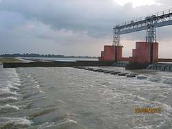
Weir
In 1932, the Anderson weir was constructed at Randiha. As a result, irrigation facility has been available in the lower Damodar basin before the advent of dams by means of the diversion weir on the Damodar and Eden canal to the extent of 890 square kilometres in the districts of Burdwan and Hooghly. Detailed examination of flow data as available at Randiha, revealed that maximum flow of 650,000 cu ft/s (18,000 m3/s) had occurred twice in August 1913 and August 1935 before the implementation of Damodar Valley Scheme.[1]
It is about 10 kilometres (6.2 mi) from Panagarh on NH 19 and about 19 kilometres (12 mi) downstream of Durgapur Barrage.[2]
Picnic spot
It is a picnic spot.[3]
Eden Canal
The Eden Canal was built in 1904 (or earlier) from Kanchannagar to Jamalpur and was linked to the Damodar canals carrying water from Randiha weir in the thirties. It provides irrigation to 10,000 hectares of land in Barddhaman district.[4][5]
Demographics
As per the 2011 Census of India Randiha had a total population of 1,953, of which 1,014 (52%) were males and 938 (47%) were females. Population below 6 years was 191. The total number of literates in Randiha was 1,274 (72.30% of the population over 6 years).[6]
References
- ↑ "Integrated Flood ManagementCase Study, India: Flood Management – Damodar River Basin" (PDF). The Associated Programme On Flood Management. World Meteorological Organization. Retrieved 2010-06-10.
- ↑ Sharad K. Jain; Pushpendra K. Agarwal; Vijay P. Singh. Hydrology and Water Resources of India. Google books. Retrieved 2010-06-10.
- ↑ "Parks and picnic spots". Retrieved 2009-09-26.
- ↑ "Complete information on some major canals of West Bengal". Preserve Articles. Retrieved 24 March 2017.
- ↑ Chattopadhyay, Akkori,Bardhaman Jelar Itihas O Lok Sanskriti (History and Folk lore of Bardhaman District.), (in Bengali), Vol I, p. 599, Radical Impression. ISBN 81-85459-36-3
- ↑ "2011 Census – Primary Census Abstract Data Tables". West Bengal – District-wise. Registrar General and Census Commissioner, India. Retrieved 20 February 2017.
Cities, towns and locations in Purba Bardhaman district | |||||||||
|---|---|---|---|---|---|---|---|---|---|
| Cities, municipal and census towns |
| ||||||||
| Locations other than cities and towns |
| ||||||||
| Related topics |
| ||||||||