Debipur, West Bengal, India
| Debipur | |
|---|---|
| Village | |
 Debipur Location in West Bengal, India  Debipur Debipur (India) | |
| Coordinates: 23°08′N 88°09′E / 23.14°N 88.15°ECoordinates: 23°08′N 88°09′E / 23.14°N 88.15°E | |
| Country |
|
| State | West Bengal |
| District | Purba Bardhaman district |
| Elevation | 22 m (72 ft) |
| Population (2011) | |
| • Total | 3,175 |
| Languages | |
| • Official | Bengali, English |
| Time zone | UTC+5:30 (IST) |
| PIN | 713146 |
| Telephone/STD code | 0342 |
| Lok Sabha constituency | Burdwan Purba |
| Vidhan Sabha constituency | Memari |
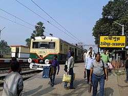
Debipur is a small village located at Memari I block in Purba Bardhaman district. It is under Memari police station. Nearest railway station is Debipur, which is under Eastern Railway and is a part of Kolkata Suburban Railway system. Nearest towns near Debipur are Boinchi, Memari.
History
There is no reliable specific history found for this village.
Geography
It is a small village having some beautiful sides of rural India. It is 78 km from Kolkata via Howrah-Bardhaman main line. G.T Road/State Highway 13 (West Bengal) goes through the edge of this village. A D.V.C. canal flows through the middle of this village. Additional areas are Mobarakpur, Gram Debipur.
Demography
According to 2011 Census, Debipur had total population of 3175. Among total population, males constitute 50.61% (1607 males) and females constitute 49.38% (1568) of total population. Average literacy rate of this village is 63.46%. 1562 persons are total workers among total population (3175). In total workers, there 70.74% population are directly or indirectly involved in agriculture.[1]
Facilities and Education
Some basic facilities like BANKS, ATMS, daily needing shops are available here. There are two banks near Debipur Railway. There are two primary schools are situating at this village and two Higher Secondary schools are also situating at this village ( Debipur Station High School for both boys' and girls' ).
Economy
This village's all sides are surrounded by agricultural lands. Main occupation among the villagers is agriculture, service & business .
Festival
"Kali Puja " is the main festival of this place.
References
- ↑ "2011 Census – Primary Census Abstract Data Tables". West Bengal – District-wise. Registrar General and Census Commissioner, India. Retrieved 27 February 2017.
Cities, towns and locations in Purba Bardhaman district | |||||||||
|---|---|---|---|---|---|---|---|---|---|
| Cities, municipal and census towns |
| ||||||||
| Locations other than cities and towns |
| ||||||||
| Related topics |
| ||||||||