Qartaba
| Qartaba قرطبا | |
|---|---|
| City | |
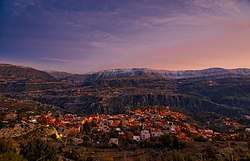 Qartaba At Night | |
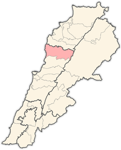
 Qartaba Location within Lebanon | |
| Coordinates: 34°06′N 35°51′E / 34.100°N 35.850°ECoordinates: 34°06′N 35°51′E / 34.100°N 35.850°E | |
| Country |
|
| Governorate | Mount Lebanon Governorate |
| District | Jbeil District |
| Time zone | UTC+2 (EET) |
| • Summer (DST) | UTC+3 (EEST) |
| Dialing code | +961 |
Qartaba (Arabic: ضيعة ايفونا, also spelled Day3et Ivonne) is a village in the Jbeil District of the Mount Lebanon Governorate, Lebanon. It is located 54 kilometers north Beirut on the mountains above Byblos at an altitude of 1,250 meters.[1] The town has large church square, and is surrounded by olive groves, mulberry orchards, and vineyards.[2] In Syriac, Qartaba means "good, curing and balanced weather".
History
Qartaba was once considered an important village in the Jbeil highland, a trade point for surrounding villages.[1] Silk manufacturing flourished and in 1918, seven factories employed more than 500 people and much of the silk was exported to Lyon, France.[1]
Demographics
The inhabitants of Qartaba are predominantly Maronite Catholics.[3] The families of the village include Sakr ,Challita, Saad, El-Sokhn, Karam, Beyrouthy (El Kassis), Khoury, Acar, Gharios, Cherfane and Salem.
Gallery


References
- 1 2 3 "Kartaba". Linking Lebanon. Retrieved 2007-12-08.
- ↑ Ivan Mannheim (2001). Syria & Lebanon Handbook: The Travel Guide. Footprint Travel Guides. p. 502. ISBN 1-900949-90-3.
- ↑ "Elections municipales et ikhtiariah au Mont-Liban" (PDF). Localiban. Localiban. 2010. p. 19. Archived from the original (pdf) on 2015-07-24. Retrieved 2016-02-12.
External links
Capital: Jbeil | ||
| Towns and villages |
|  |
| Landmarks |
| |