Mazraat es-Siyad
| Mazraat es-Siyad مزرعة السياد | |
|---|---|
 | |
 Mazraat es-Siyad Location in Lebanon | |
| Coordinates: 34°6′15″N 35°51′35″E / 34.10417°N 35.85972°ECoordinates: 34°6′15″N 35°51′35″E / 34.10417°N 35.85972°E | |
| Country |
|
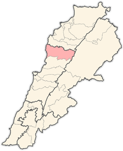
| Governorate | Mount Lebanon |
| District | Jbeil |
| Government | |
| • Mayor | Robert Tony Gharios |
| Area | |
| • Total | 6.65 km2 (2.57 sq mi) |
| Highest elevation | 1,250 m (4,100 ft) |
| Time zone | UTC+2 (EET) |
| • Summer (DST) | UTC+3 (EEST) |
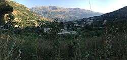
Mazraat es-Siyad (also transliterated Mazraet es-Siyed; Arabic: مزرعة السياد pronounced [Mazraʿat Assiyad]) is a small town in the highlands of the Jbeil District in the Mount Lebanon Governorate, Lebanon. The town is 58 kilometres (36 mi) away from Beirut and stands at an elevation of 1,250 meters above sea level.[1]
History
Mazraat es-Siyad translates as "grange of the masters" in Arabic. It is named after the Shia siyyad (masters) of the al-Husseini family whose ancestor, Sayyed Hussein al-Husseini, was the first person to reside in the area after he restored an ancient monastery. The monastery was bestowed to him by Sheikh Nawfal Ibrahim al-Khoury during the Mamluk era (13th–15th centuries).[1]
Geography
Mazraat es-Siyyad is located in the Jbeil District in the Mount Lebanon Governorate. It is 58 kilometers north of the capital Beirut. It spans an area of 6.65 square kilometres (2.57 sq mi) and stands at an altitude of 1,250 meters above sea level. The municipal area of Mazraat es-Siyad includes the hamlets of Abboud, Mazraat er-Rmeileh, Sharbineh and Bolhos.[1]
Demographics
According to the Lebanese resource center, Localiban, Mazraat es-Siyad's inhabitants are mostly Maronite Christians, with a small Shia Muslim minority.[1] However, according to NOW News, the inhabitants are mostly Shia Muslims.[2] The population lives in a total of 220 houses in the town. There were 1,250 voters from Mazraat es-Siyad registered in 2005. The largest families in order of size according to the 2005 election records are al-Husseini, Karkaba, Bou-Gharios, Abi-Acar, Obeid, Gharios, Zaarour, Barakat, Bou-Salman, Karam, Ziadé and El-Khoury. Other families include Salemé, Oueiss, Medawar, Maatouk, Bou-Yazbek and Aouad.[1]
Government
Mazraat es-Siyad municipality was established in 2004.[3] The municipal council currently has twelve members.[1] As of 2005, it was presided over by Daniel Gharios. As of 2010, it was headed by Robert Tony Gharios. In addition to the municipal council, Mazraat es-Siyad has a three-member mayoral council headed by a mukhtar (headman), who was Gerges Naja Obeid in 2005.[1]
Economy
Agriculture, namely pomology is the main economic activity in the Jbeil highlands. Mazraet es-Siyad has many natural water sources, fertile soil and arable land. Residents also depend on permanent jobs, as there are 15 small commercial and industrial companies, in addition to two hotels, the Shangri-La and the Monte Carlo.[1]
Landmarks
Religious buildings
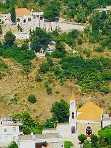
- Mar Abda (Saint Abdas) Church founded by Gharios family in 1708 and greatly expanded in later centuries.
- Mazra’at As-Siyyad Mosque which was built in line with a decision by Mutasarrıf Wasa Pasha (ruled 1883-1892).
- Saydet an-Najat (Our Lady of Salvation) Church.
Culture
Festivities
Mazraat es-Siyad celebrates the Feast of the Lady of Salvation (Saydet an-Najat) on 8 September and Saint Abdas on 31 August with traditional dinners and festivities.[1]
Notable residents
- Ahmad al-Husseini, Lebanese parliament deputy elected in 1932.[4]
References
- 1 2 3 4 5 6 7 8 9 Localiban (15 June 2015). "Mazraat Es Siyad". Localiban, Administrative Divisions of Lebanon. Data Center on Local Development in Lebanon. Retrieved 9 July 2015.
- ↑ "Districts in Depth: Jbeil". NOW News. 2009-05-28. Retrieved 2016-02-12.
- ↑ Jbeil Files staff (29 June 2011). "نبذة تاريخية عن نشأة البلديات في قضاء جبيل". تاريخ جبيل (in Arabic). Jbeil Files. Archived from the original on 26 September 2015. Retrieved 9 July 2015.
- ↑ القصيفي, ايلي (7 September 2012). "قرطبـا تتقـن لعبـة الجمـال" (in Arabic). Assafir. Retrieved 9 July 2015.
Capital: Jbeil | ||
| Towns and villages |
|  |
| Landmarks |
| |