Bahour
| Bahour பாகூர் | |
|---|---|
| Town | |
 Bahour Location in Puducherry, India  Bahour Bahour (India) | |
| Coordinates: 11°48′21″N 79°44′34″E / 11.8057275°N 79.7426721°ECoordinates: 11°48′21″N 79°44′34″E / 11.8057275°N 79.7426721°E | |
| Country |
|
| State | Puducherry |
| District | Puducherry |
| Taluk | Bahour |
| Commune | Bahour |
| Population (2001) | |
| • Total | 36,983 |
| Languages | |
| • Official | Tamil, English, French |
| Time zone | UTC+5:30 (IST) |
| PIN | 607 402 |
| Telephone code | 0413 |
| Vehicle registration | PY-01 |
| Sex ratio | 50% ♂/♀ |
Bahour (Tamil: பாகூர்) is a town, Commune, Taluk and Assembly Constituency in the Union Territory of Puducherry, India. It consists of 4 non-contiguous areas, including 3 of the 9 true enclaves of Puducherry. Bahour has reports of Lignite deposits but it is not exploited due to its close proximity to the sea and the likelihood of seepage of seawater, thus adulterating the ground water. It is a major access point for villages south of Puducherry and forms southern border to the Union territory.
History
Mulanathaswami Temple belonging to Chola period provides more information about Bahour's History. Evidence exists for ancient Sanskrit college in Bahour.
Demographics
As of 2001 India census,[1] Bahour had a population of 36,983. Males constitute 50% of the population and females 50%. Bahour has an average literacy rate of 81.49%, male literacy is 88.89%, and female literacy is 74.13%. In Bahour, 10% of the population is under 6 years of age.
Geography
Bahour is located at 11.806° N 79.74°E. Bahour is 21 km. from Puducherry city. It is directly connected with Puducherry and Cuddalore by frequent bus service.
Road Network
Five RC Roads passes through Bahour. They are
Place of interest
Mulanathaswami Temple, Bahour
Mulanathaswami Temple is located in the heart of Bahour. This temple belongs to Chola period. Marvel sculptures in the temple displays Chola's architecture. It is declared as an Archaeological monument and is maintained by ASI.[2]
Bahour Lake
Bahour Lake is a major tourist spot in Bahour. It is one of the Important Bird Areas (IBA) in Puducherry[3], the other being Ossudu Lake. Bahour lake is the second largest lake in Puducherry. It gets feed from South Penniar via Bangaru Canal.
Gallery
 Marvel sculptures in the temple
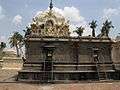 View from Southern direction
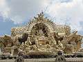 Dhakshnamoorthy Sculpture
 Mulanathaswami Temple
 Bahour Lake
 Distance to Places reachable from East of Bahour
 Distance to Places reachable from West of Bahour
References
- ↑ "Census of India 2001: Data from the 2001 Census, including cities, villages and towns (Provisional)". Census Commission of India. Archived from the original on 2004-06-16. Retrieved 2008-11-01.
- ↑ http://asi.nic.in/asi_monu_alphalist_pondicherry.asp
- ↑ Islam, M.Z. & A.R. Rahmani (2004). Important Bird Areas in India: Priority sites for conservation. Indian Bird Conservation Network: Bombay Natural History Society and Birdlife International (UK).Pp.xviii+1133
External links
| Wikimedia Commons has media related to Bahour. |