Portage, New York
| Portage | |
|---|---|
| Town | |
 Portage Location of Portage in New York | |
| Coordinates: 42°33′36″N 77°59′04″W / 42.56000°N 77.98444°WCoordinates: 42°33′36″N 77°59′04″W / 42.56000°N 77.98444°W | |
| Country | United States |
| State | New York |
| County | Livingston |
| Government | |
| • Type | Town Council |
| • Town Supervisor | Ivan C. Davis (D, R) |
| • Town Council |
Members' List
|
| Area[1] | |
| • Total | 26.64 sq mi (68.99 km2) |
| • Land | 26.40 sq mi (68.37 km2) |
| • Water | 0.24 sq mi (0.61 km2) 0% |
| Population (2010) | |
| • Total | 884 |
| • Estimate (2016)[2] | 855 |
| • Density | 32.39/sq mi (12.50/km2) |
| FIPS code | 36-051-59179 |
Portage is a town in the southwest corner of Livingston County, New York, United States. The town is near the south end of Letchworth State Park. The name of the town stems from the need to portage (carry) canoes around the falls of the Genesee River.
History
The town was first settled around 1810. Portage was formed from part of the town of Nunda in 1827.
The "High Bridge at Portage," built in 1853, was once considered an engineering wonder for wood construction. It was destroyed by a fire in 1875. That same year the bridge was rebuilt in iron according to a design by the railroad engineer Octave Chanute, who later became a pioneer of aviation. The iron bridge still stands today, but not for long. In 2015 construction began to build a new high bridge to replace the current bridge due to the structure and age of the current bridge.
Geography
According to the United States Census Bureau, the town has a total area of 26.6 square miles (69.0 km²), of which, 26.4 square miles (68.3 km²) of it is land and 0.2 square miles (0.6 km²) of it (0.94%) is water.[3]
The western border of the town is formed by the Genesee River and the Genesee River Gorge. The west town line is the border of Wyoming County, and the south town line is the border of Allegany County.
New York State Route 436 is an east-west highway across the town, that intersects New York State Route 70 west of the community of Oakland.
Adjacent towns and areas
Portage is bounded on the east by the town of Nunda and on the north by the town of Mount Morris. To the south are the towns of Granger and Grove in Allegany County. To the west is the town of Genesee Falls in Wyoming County, on the opposite side of the Genesee River.
Demographics
| Historical population | |||
|---|---|---|---|
| Census | Pop. | %± | |
| 1850 | 2,478 | — | |
| 1860 | 1,519 | −38.7% | |
| 1870 | 1,338 | −11.9% | |
| 1880 | 1,295 | −3.2% | |
| 1890 | 1,130 | −12.7% | |
| 1900 | 1,029 | −8.9% | |
| 1910 | 1,273 | 23.7% | |
| 1920 | 860 | −32.4% | |
| 1930 | 793 | −7.8% | |
| 1940 | 945 | 19.2% | |
| 1950 | 737 | −22.0% | |
| 1960 | 733 | −0.5% | |
| 1970 | 731 | −0.3% | |
| 1980 | 771 | 5.5% | |
| 1990 | 893 | 15.8% | |
| 2000 | 859 | −3.8% | |
| 2010 | 884 | 2.9% | |
| Est. 2016 | 855 | [2] | −3.3% |
| U.S. Decennial Census[4] | |||
As of the census[5] of 2000, there were 859 people, 308 households, and 232 families residing in the town. The population density was 32.6 per square mile (12.6/km²). There were 352 housing units at an average density of 13.3/sq mi (5.2/km²). The racial makeup of the area was 97.09% White, 0.12% African American, 0.23% Native American, 0.35% Asian, and 2.21% from two or more races. Hispanic or Latino of any race were 0.81% of the population.
There were 308 households out of which 40.3% had children under the age of 18 living with them, 56.2% were married couples living together, 10.1% had a female householder with no husband present, and 24.4% were non-families. 16.9% of all households were made up of individuals and 8.1% had someone living alone who was 65 years of age or older. The average household size was 2.79 and the average family size was 3.11.
In the town, the population was spread out with 30.7% under the age of 18, 6.9% from 18 to 24, 28.4% from 25 to 44, 23.2% from 45 to 64, and 10.8% who were 65 years of age or older. The median age was 35 years. For every 100 females, there were 101.6 males. For every 100 females age 18 and over, there were 100.3 males.
The median income for a household in the town was $32,500, and the median income for a family was $38,750. Males had a median income of $29,000 versus $18,846 for females. The per capita income for the town was $13,717. About 9.2% of families and 14.0% of the population were below the poverty line, including 16.3% of those under the age of 18 and 14.1% ages 65 or older.
Communities and locations in Portage
- Dalton – A hamlet (and census-designated place) on the east town line.
- Deowesta – A former native town near the portage of the Genesee River.
- Hunt – A hamlet (and census-designated place) west of Hunt's Hollow on Main Street. The G.A.R. Memorial Hall was added to the National Register of Historic Places in 2006.[6]
- Hunt's Hollow – A hamlet on NY-70 in the center of the town.
- Keshequa Creek – A stream flowing through the town.
- Oakland – A hamlet in the northern part of the town on Route 436. Edgerley was added to the National Register of Historic Places in 1980.[6]
- Portage – A hamlet on the western border of the town south of the Upper, Middle, and Lower Falls on the Genesee River. The hamlet in located on NY-436 across the river from Portageville which is located in Wyoming County. It was formerly called "Portage Station."
References
- ↑ "2016 U.S. Gazetteer Files". United States Census Bureau. Retrieved Jul 5, 2017.
- 1 2 "Population and Housing Unit Estimates". Retrieved June 9, 2017.
- ↑ "US Gazetteer files: 2010, 2000, and 1990". United States Census Bureau. 2011-02-12. Retrieved 2011-04-23.
- ↑ "Census of Population and Housing". Census.gov. Retrieved June 4, 2015.
- ↑ "American FactFinder". United States Census Bureau. Retrieved 2008-01-31.
- 1 2 National Park Service (2009-03-13). "National Register Information System". National Register of Historic Places. National Park Service.
External links
Municipalities and communities of Livingston County, New York, United States | ||
|---|---|---|
| Towns | 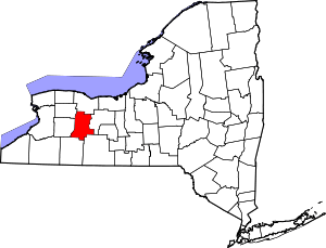 | |
| Villages | ||
| CDPs | ||
| Other hamlet | ||