Karuppanadhi Dam
| Karuppanadhi Dam | |
|---|---|
 | |
 Location of the Karuppanadhi Dam in Tamil Nadu | |
| Country | India |
| Location | Chokkampatti, Tirunelveli district, Tamil Nadu |
| Coordinates | 9°08′15.5″N 77°18′12.7″E / 9.137639°N 77.303528°ECoordinates: 9°08′15.5″N 77°18′12.7″E / 9.137639°N 77.303528°E |
| Purpose | Irrigation |
| Status | Completed |
| Construction began | 1971 |
| Opening date | 1977 |
| Owner(s) | Government of Tamilnadu |
| Dam and spillways | |
| Height | 22 m (72 ft) |
| Length | 890 m (2,920 ft) |
| Spillways | 2 |
| Spillway type | OG |
| Spillway capacity | 357 m3 (12,607 cu ft) |
| Reservoir | |
| Total capacity | 5,240,000 m3 (185,048,854 cu ft)[1] |
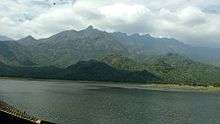
The Karuppanadhi Dam is located at the foot hills of Western Ghats built across the Karuppanadhi river near Chokkampatti, in the Tirunelveli district of Tamil Nadu, southern India. It provides water for irrigation to the region of Kadayanallur Taluk.
History
The dam construction was started in 1971 and it took six years to complete. The dam was opened in the year of 1977.
Dimensions and capacity
- Maximum height of the dam is 38.64 m
- Effective capacity of the dam at FRL is 5.239 Mcum
- Length of masonry dam is 890 m
- Catchment area is 29.34 km2 [2]
Maintenance
Karuppanadhi Dam is maintained by Water Resources Department which in turn managed by the Tamil Nadu Public Works Department.[3]
Transportation
By Road:The dam is situated at 13 km from Kadayanallur, and 82 km from Tirunelveli.
By Train:The nearest railway station is Kadayanallur station. Kadayanallur station is well connected with Madurai and Chennai.
By Air:The nearest airport is Tuticorin Airport(TCR) which is 122 km away from the Dam. Air connectivity is available from Chennai. International connectivity is available to Chennai