Chengam
| Chengam sezhunganiyur | |
|---|---|
| Municipality | |
 Chengam Location in Tamil Nadu, India | |
| Coordinates: 12°18′N 78°48′E / 12.3°N 78.8°ECoordinates: 12°18′N 78°48′E / 12.3°N 78.8°E | |
| Country |
|
| State | Tamil Nadu |
| District | Tiruvanamalai |
| Elevation | 272 m (892 ft) |
| Population (2011) | |
| • Total | 54,278 |
| Languages | |
| • Official | Tamil |
| Time zone | UTC+5:30 (IST) |
| Vehicle registration | TN 25 |
Geography
Chengam is located at 12°18′N 78°48′E / 12.3°N 78.8°E.[1] It has an average elevation of 272 metres (892 feet).
Demographics
Chengam is a Municipality in Tiruvannamalai district.As of 2011 India census,[2] Chengam had a population of 54278. Chengam has an average literacy rate of 79.3.Child population in the age below 6 was 2210 males and 2479 females.This town is also famous for Big historic temple (Venugopala Parthasarathy Temple).
| Historical population | ||
|---|---|---|
| Year | Pop. | ±% |
| 1901 | 3,867 | — |
| 1921 | 6,305 | +63.0% |
| 1931 | 9,457 | +50.0% |
| 1941 | 11,678 | +23.5% |
| 1951 | 14,912 | +27.7% |
| 1961 | 17,441 | +17.0% |
| 1981 | 23,462 | +34.5% |
| 1991 | 31,196 | +33.0% |
| 2001 | 41,037 | +31.5% |
| 2011 | 54,278 | +32.3% |
| Sources: | ||
Culture
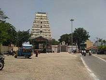
Chengam Sri VenuGopala Parthasarathy Perumal Temple is more than 700 years old. Its architecture and layout is a model for Annamalaiyar Temple.
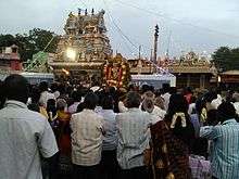
Chengam Sri VenuGopala Parthasarathy Perumal Temple festival is held annually in May in makakaruta waxing service with great karutacevai kotierrat festival over 10 days
- 1st day of the festival will be held on behalf of the community on the occasion of overriding alapputtur Naidu's kotierramum tiruviti browsing Swami held at Anna's vehicle.
- 2nd day in the morning in a ceremony held on behalf Nadars curiyapiraiyilum vatunal rice, Swami tiruvitiula vehicle is lion night.
- 3rd day Chengam tirukalyanam on behalf Yadavas, night anumantavakana browsing.
- 4th day Chengam nakavakana night stroll on the city's behalf poyaccettiyarkal.
- 5th day makakaruta service Chengam Round Tower held on behalf VANNIYAR Darshan program,
- 6th day morning on behalf Yadavas putupettai festival, Hindu merchants night, on behalf of the Arya Vaishya community elephant procession takes place in the vehicle.
- 7th day Chengam tertiruvila on behalf pantarettiyarkal takes place in the morning.
- 8th day and night on behalf of the horse vehicle kammavar Naidu,
- 9th day Chengam kavarainayutukal night on behalf of Lord Indra plane going tiruvitiula.
- 10th day festival will be celebrated by revenue department, forest department, and in the morning on behalf devasthanam ceyyarrankarai unloading program of the evening will be held at the Swami theerthavari.
For this festival temple will be colored lights, fireworks, naiyantimelam, karakattam (dance), is beckoning. Preparations have been made for the show by festival committee and sponsors.
Roadways
Chengam lies on the mid-way of NH66 plying from Bangalore to Puducherry via Thiruvannamalai.It is separated from Thiruvannamalai at a distance of 35km.It is well connected with major nearby Metro City Is Vellore City. Major towns like Polur, Thiruvannamalai, Singarapettai, Pudupalayam, Sathanur Dam, Thandarampattu and Uthangarai. Frequent buses ply from chengam to Salem, Dharmapuri, Bangalore, Hosur, Krishnagiri, Tirupattur, Vellore, Chennai, Polur, Uthangarai, Hogenakkal, Pondicherry, Thiruvannamalai, Kallakurichi, Vizhuppuram and Chidambaram. Local town buses ply to Sathanur Dam, Kadaladi, Kanchi, Polur, Pudupalayam, Singarapettai,Neepathurai,Mel ravanthavadi,Thaazhaiyoothu, Thandarampattu, Pachal and many other villages.
- Indian Overseas Bank ( kanji tiruvannamalai road)
- Indian Bank (Polur Main road)
- State Bank of India (Thuruvannamalai Highway)
- Union Bank of India (Pudhupalayam)
- ICICI Bank (Thiruvannamalai Highway)
- Indian Overseas Bank (Opp street to Taluk office)
- Karur Vysya Bank (Raja street)
- Tamil Nadu Mercantile Bank (Polur Main Road)
- Thiruvannamalai co-op central Bank (Opp street to Taluk office)
- Bank of India (Mel pallipattu)
Education
Secondary schools
- Sri Rama Krishna matriculation higher secondary school
- Sahaya Madha matriculation higher secondary school
- Maharishi matriculation higher secondary school
- Sri Vivekananda matriculation higher secondary school
- Bharath matriculation higher secondary school
- Sri Sankara Vidhyalaya school
- Government Boys higher secondary school
- Government Girls higher secondary school
Colleges
Sathyam College of Arts & Science ( Tiruvanamalai highway, Kariamangalam)
- Government Polytechnic College (Polur Main Road)
- Sri Sakthi Polytechnic College (Nachipattu)
- Arun Krishna Arts and Science College (Valayambattu Road)
- Sun Arts and Science College (Thiruvannamalai Road)
- Meenakshi College of Education (Thiruvannamalai Road)
- Aruna Vidhya arts & Science College ( Tiruvanamalai highway)
- Idhaya Arts & science womens college (Tiruvannamalai Higway, Kalpayir)
Politics
Initially Chengam was an assembly constituency (SC) of Tiruppattur (Lok Sabha constituency). In 2009 it changed to Tiruvannamalai Lok Sabha constituency.
Places of interest
- Sathanur Dam (20 km) great
- Thiruvannamalai Temple (30 km)
- Kuppanatham Dam (15 km)
- Theerthamalai (30 km via Mel Ravanthavadi, Neepathurai)
- Gingee Fort (60 km via Thiruvannamalai)
- Kalpair vallalar Temple (28 km)
Factories
- Jeppiar Milk Factory (Thiruvannamali Road)
- Government Milk Factory (Thiruvannamalai Road
References
- ↑ Falling Rain Genomics, Inc - Chengam
- ↑ "Census of India 2001: Data from the 2001 Census, including cities, villages and towns (Provisional)". Census Commission of India. Archived from the original on 2004-06-16. Retrieved 2008-11-01.
- ↑ "Population Details". Tiruvannamalai municipality. 2011. Archived from the original on 2014-02-27. Retrieved 2012-12-29.
- ↑ "Census Info 2011 Final population totals – Salem(05740)". Office of The Registrar General and Census Commissioner, Ministry of Home Affairs, Government of India. 2013. Retrieved 26 January 2014.