Bhavanisagar dam
| Bhavanisagar Dam | |
|---|---|
 Bhavanisagar Dam and Reservoir | |
| Official name | Bhavanisagar anaicut |
| Location | Bhavanisagar, Sathyamangalam, Tamil Nadu, India |
| Coordinates | 11°28′15″N 77°6′50″E / 11.47083°N 77.11389°ECoordinates: 11°28′15″N 77°6′50″E / 11.47083°N 77.11389°E |
| Purpose | Irrigation, power |
| Status | Open |
| Construction began | 1948 |
| Opening date | 1955 |
| Construction cost | ₹210 million (US$2.9 million) |
| Owner(s) | Government of Tamil Nadu |
| Operator(s) | Government of Tamil Nadu |
| Dam and spillways | |
| Type of dam | Earthen |
| Impounds | Bhavani River |
| Height (foundation) | 40 m (130 ft) |
| Height (thalweg) | 120 ft (37 m) |
| Length | 8 km (5.0 mi) |
| Reservoir | |
| Creates | Bhavanisagar Reservoir |
| Total capacity | 32.8×10⁹ cu ft (930×106 m3) |
| Turbines | 2 |
| Installed capacity | 32 MW (43,000 hp) |
| Source[1] | |
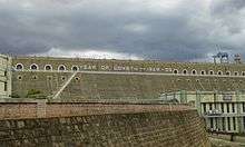
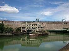
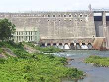
Bhavanisagar Dam or Lower Bhavani Dam, is located in Erode district, Tamil Nadu, India.[2] It is constructed on the Bhavani river.[1] It is one of the world's largest earthen dams. The dam is situated some 16 km (9.9 mi) west of Sathyamangalam, is 15 km (9.3 mi) from Punjai Puliampatti ,is 35 km (22 mi) from Gobichettipalayam and is 36 km (22 mi) north-east of Mettupalayam.[3]
History
The Lower Bhavani Project was the first major irrigation project initiated in India after independence in 1948. It was completed by 1955 and opened for use in 1956.[1] The dam was constructed at a cost of ₹21 (29¢ US).[1]
Dimensions
The dam is 8 km (5.0 mi) long by 40 m (130 ft) high. The full reservoir level is 120 ft (37 m) and the dam has a capacity of 32.8×10⁹ cu ft (930×106 m3).[1]
Hydrography
Bhavanisagar dam is constructed on the Bhavani River. The dam receives water from two main catchment areas in the Western Ghats. The water is fed into the Bhavani river known as Upper Bhavani. The eastern catchment area includes the Upper Bhavani, Avalanche and Emerald lakes, Kundha, Gedhai, Pillur and Nellithurai. The western catchment area includes Portimund, Parson’s valley, Pykara, Glenmorgan, Chinkara, Maravakandy, Moyar and Thengumarahatta.[1] The dam is fed by both Southwest and Northeast monsoons.[1]
The dam feeds water into two canals, Lower Bhavani Project Canal and Kalingarayan Canal.[4][5] The Kalingarayan canal feeds Thadapalli and Arakkankottai channels and the LBP canal feeds the Thadapalli and Arakankottai channels.[6]
| Canal | Ayacut area |
|---|---|
| Lower Bhavani Project Canal | 205 thousand acres (830 km2) |
| Kalingarayan canal | 15.743 thousand acres (63.71 km2) |
| Thadapalli and Arakankottai | 24.504 thousand acres (99.16 km2) |
Power generation
The dam has two hydrodelectric power stations, one on the east bank canal and the other on the Bhavani river. Each has a capacity of 8 megawatts (11,000 hp) for a total capacity of 16 megawatts (21,000 hp).[1]
See also
References
- 1 2 3 4 5 6 7 8 "Uniqueness of Bhavanisagar dam" (PDF). CSTI. Retrieved 1 February 2016.
- ↑ "Tourist Information for Erode district". Government of Tamil Nadu. Retrieved 1 February 2016.
- ↑ "Bhavanisagar dam" (PDF). TNAU. Retrieved 1 February 2016.
- ↑ "Breach in LBP Canal plugged". The Hindu. 27 November 2008.
- ↑ "Large Scale Irrigation Systems". FAO. Retrieved 1 February 2016.
- ↑ "Bhavani Sagar dam: farmers raise apprehension on water position". The Hindu. 26 October 2010.
| District Headquarters | 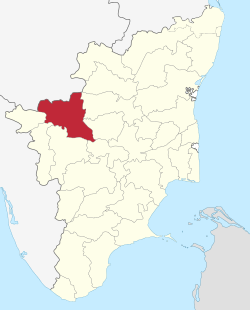 | |
|---|---|---|
| Country | ||
| State | ||
| Region | ||
| Divisions | ||
| Taluks | ||
| Municipal Corporations | ||
| Municipalities | ||
| Other Major Panchayat Towns | ||
| Rivers | ||
| History | ||
| Temples | ||
| Places of interest | ||
| ||
| Wikimedia Commons has media related to Bhavanisagar Dam. |