Manimuthar Dam
| Manimuthar Dam | |
|---|---|
 | |
 Location of the Manimuthar Dam in Tamil Nadu | |
| Country | India |
| Location | Manimutharu, Tirunelveli District, Tamil Nadu |
| Coordinates | 8°39′14″N 77°24′48″E / 8.653804°N 77.413418°ECoordinates: 8°39′14″N 77°24′48″E / 8.653804°N 77.413418°E |
| Purpose | Irrigation |
| Opening date | 1958 |
| Dam and spillways | |
| Type of dam | Gravity dam |
| Height | 118 ft (36 m) |
| Height (foundation) | 150 ft (46 m) |
| Length | 9,268 ft (2,825 m) |
| Spillways | 7 |
| Spillway type | Chute |
| Reservoir | |
| Creates | Manimuthar reservoir |
| Total capacity | 5.51×10⁹ cu ft (126,492 acre⋅ft) |
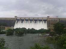
The Manimuthar Dam is located in Manimutharu 50.8 kilometres (31.6 mi) away from Tirunelveli in Tamil Nadu, India. It the biggest reservoir of the Tirunelveli district.[1][2][3][4] This dam was built in 1958 near Singambatti, by the then Tamil Nadu Chief Minister Kamaraj and K T Kosalram MP to prevent the mixing of Rainwater with the Bay of Bengal during the rainy season. In this dam we can hold water up to 118 feet. The dam is 5,511 million cubic feet. The total length of the dam is 3 km It irrigated Around 65,000 acres of areas in the northern part of the Nanguneri Taluk and Thisayanvilai and Southern Veeravanallur, Karispalpatti which are not irrigated by Pachaiyarai in Tirunelveli district.[5]
References
- ↑ "Papanasam dam filling up, finally". Thehindu.com. 28 June 2017. Retrieved 12 December 2017.
- ↑ "Manimuthar Dam D00969 -". India-wris.nrsc.gov.in. Retrieved 12 December 2017.
- ↑ "Water Reservoirs". Nellai.tn.nic.in. Retrieved 12 December 2017.
- ↑ "Manimuthar dam overflows". Thehindu.com. 21 December 2014. Retrieved 12 December 2017.
- ↑ அ.அருள்தாசன் (2015-03-19). "பாபநாசம், மணிமுத்தாறு, சேர்வலாறு: படியளக்கும் அணைகள் பாதுகாக்கப்படுமா?". Tamil.thehindu.com. தி இந்து. Retrieved 8 November 2017.
| Wikimedia Commons has media related to Manimuthar Dam. |
This article is issued from
Wikipedia.
The text is licensed under Creative Commons - Attribution - Sharealike.
Additional terms may apply for the media files.