Polk Township, Washington County, Indiana
| Polk Township | |
|---|---|
| Township | |
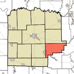 Location in Washington County | |
| Coordinates: 38°31′43″N 85°56′38″W / 38.52861°N 85.94389°WCoordinates: 38°31′43″N 85°56′38″W / 38.52861°N 85.94389°W | |
| Country | United States |
| State | Indiana |
| County | Washington |
| Government | |
| • Type | Indiana township |
| Area | |
| • Total | 35.99 sq mi (93.2 km2) |
| • Land | 35.84 sq mi (92.8 km2) |
| • Water | 0.15 sq mi (0.4 km2) 0.42% |
| Elevation | 768 ft (234 m) |
| Population (2010) | |
| • Total | 2,626 |
| • Density | 73.3/sq mi (28.3/km2) |
| ZIP codes | 47106, 47126, 47165, 47167 |
| GNIS feature ID | 0453757 |
Polk Township is one of thirteen townships in Washington County, Indiana, United States. As of the 2010 census, its population was 2,626 and it contained 1,131 housing units.[1]
Geography
According to the 2010 census, the township has a total area of 35.99 square miles (93.2 km2), of which 35.84 square miles (92.8 km2) (or 99.58%) is land and 0.15 square miles (0.39 km2) (or 0.42%) is water.[1]
Cities, towns, villages
- New Pekin (east half)
Unincorporated towns
- Bartle at 38°33′37″N 85°53′15″W / 38.560338°N 85.887470°W
- Blue River at 38°31′48″N 85°56′22″W / 38.530060°N 85.939416°W
- Daisy Hill at 38°30′22″N 85°56′22″W / 38.506172°N 85.939416°W
- Old Pekin at 38°29′50″N 86°00′12″W / 38.497282°N 86.003307°W
(This list is based on USGS data and may include former settlements.)
Adjacent townships
- Franklin Township (north)
- Finley Township, Scott County (northeast)
- Monroe Township, Clark County (east)
- Wood Township, Clark County (south)
- Jackson Township (southwest)
- Pierce Township (west)
- Washington Township (northwest)
Cemeteries
The township contains these three cemeteries: Mead, Mount Pleasant and Tash.
School districts
- East Washington School Corporation
Political districts
- Indiana's 9th congressional district
- State House District 73
- State Senate District 45
References
- United States Census Bureau 2007 TIGER/Line Shapefiles
- United States Board on Geographic Names (GNIS)
- IndianaMap
- 1 2 "Population, Housing Units, Area, and Density: 2010 - County -- County Subdivision and Place -- 2010 Census Summary File 1". United States Census. Retrieved 2013-05-10.
External links
This article is issued from
Wikipedia.
The text is licensed under Creative Commons - Attribution - Sharealike.
Additional terms may apply for the media files.