Canton, Indiana
| Canton, Indiana | |
|---|---|
| Unincorporated community | |
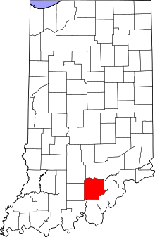 Washington County's location in Indiana | |
 Canton Canton's location in Washington County | |
| Coordinates: 38°37′26″N 86°02′05″W / 38.62389°N 86.03472°WCoordinates: 38°37′26″N 86°02′05″W / 38.62389°N 86.03472°W | |
| Country | United States |
| State | Indiana |
| County | Washington |
| Township | Washington |
| Elevation[1] | 869 ft (265 m) |
| Time zone | UTC-5 (Eastern (EST)) |
| • Summer (DST) | UTC-4 (EDT) |
| ZIP code | 47167 |
| Area code(s) | 812, 930 |
| GNIS feature ID | 432116 |
Canton is an unincorporated community in Washington Township, Washington County, in the U.S. state of Indiana.[2]
History
Canton was laid out and platted in 1838.[3][4] An old variant name of the community was called Greensburg.[5]
A post office was established at Canton in 1835, and remained in operation until it was discontinued in 1905.[6]
Geography
Canton is located at 38°37′26″N 86°02′05″W / 38.62389°N 86.03472°W at an elevation of 866 feet.
References
- ↑ "US Board on Geographic Names". United States Geological Survey. October 25, 2007. Retrieved 2016-07-07.
- ↑ "Canton, Indiana". Geographic Names Information System. United States Geological Survey. Retrieved July 26, 2017.
- ↑ History of Lawrence, Orange, and Washington Counties, Indiana: From the Earliest Time to the Present. Higginson Book Company. 1884. p. 781.
- ↑ Stevens, Warder William; Davis, Lulie (1916). Centennial History of Washington County, Indiana: Its People, Industries and Institutions. McDowell Publications. p. 549.
- ↑ "USGS detail on Canton - Variant Citation". Retrieved 2016-07-21.
- ↑ "Washington County". Jim Forte Postal History. Retrieved July 7, 2016.
This article is issued from
Wikipedia.
The text is licensed under Creative Commons - Attribution - Sharealike.
Additional terms may apply for the media files.