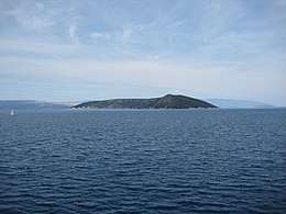
Plavnik
 | |
 | |
| Geography | |
|---|---|
| Coordinates | 44°58′02″N 14°31′30″E / 44.96722°N 14.52500°ECoordinates: 44°58′02″N 14°31′30″E / 44.96722°N 14.52500°E |
| Archipelago | Kvarner Gulf |
| Area | 8.64 km2 (3.34 sq mi)[1] |
| Highest point | 194 m |
| Administration | |
|
Croatia | |
| County | Primorje-Gorski Kotar |
| Municipality | Krk (town) |
| Demographics | |
| Population | 0 (2010) |
Plavnik is an unpopulated island in the Adriatic Sea, belonging to Croatia located between the Central Straits and the Kvarner Bay. The Krusija Channel cuts it off from the eastern coast of the island of Cres.[2] This channel is the shortest route from the Adriatic Sea through the islands to Rijeka. A lighthouse established in 1890, sits at the northwestern point of the islet, marking the east side of the narrowest opening of the Krusija Channel.[3]
Geography
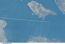
While covering an area of 8.64 km2,[4] the island has a length of 6.3 kilometres (3.9 miles) and a width of up to 2.3 km (1.4 miles). Its highest elevation is 194 metres (636 feet). Most of the island does not have vegetation. On the northern and north-eastern sides, the coastline is partially steep. Two islets that make up Kornati, lie to the southeast of Plavnik. In the middle of the straits between these islands and Plavnik, the sea depth is about 9 metres (30 feet).
Flora and fauna
Plavnik is home to birds such as the wheateaters, pheasant, and white-headed vulture. Hares are common as well. As of 2010, the islet is in the process of being declared a zoological and botanical reserve.
References
- ↑ Hydrographic Institute of the Republic of Croatia (2004). "Coastline lengths and areas of islands in the Croatian part of the Adriatic Sea determined from the topographic maps at the scale 1:25,000" (PDF). Geoadria. p. 12. Retrieved 10 June 2010.
- ↑ "Plavnik". croatiatouristcenter.com. 2006. Archived from the original on 2006-06-21. Retrieved 2010-10-24.
- ↑ Rowlett, Russ (2010-02-14). "Lighthouses of Northern Croatia". research. unc.edu (University of North Carolina). Retrieved 2010-10-24.
- ↑ Duplančić Leder, Tea; Ujević, Tin; Čala, Mendi (June 2004). "Coastline lengths and areas of islands in the Croatian part of the Adriatic Sea determined from the topographic maps at the scale of 1 : 25 000" (PDF). Geoadria. Zadar. 9 (1): 5–32. Retrieved 2011-01-21.
External links
| Wikimedia Commons has media related to Plavnik. |
- Plavnik at CroatiaTouristCenter.com