Paklinski Islands
| Native name: Pakleni otoci Nickname: Škoji | |
|---|---|
 | |
| Geography | |
| Location | Adriatic Sea |
| Total islands | 16 |
| Major islands | Sveti Klement, Marinkovac |
| Area | 7.165093 km2 (2.766458 sq mi) |
| Highest elevation | 94 m (308 ft) |
| Highest point | Vela glava |
| Administration | |
|
Croatia | |
| County | Split |
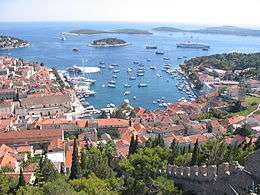
The Pakleni (pronounced [pǎklɛniː]) or sometimes referred as Paklinski ([pâkliːnskiː]) islands are located off the southwest coast of the island of Hvar, Croatia, opposite the entrance to the Hvar (city) harbour. Usual local name is Škoji, which means Islands. The name is popularly translated as Hells' islands (pakleni: hellish),[1] but it originally derives from paklina, an archaic word, from which pakleni is derived. too. "Paklina" means "tar", and in this case refers to the pine resin once used to coat ships that was harvested on these islands.[2]
Overview
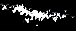
The islands are (from west to east):
| Island | Area (km2)[3] |
|---|---|
| Vodnjak Mali | 0.252666 |
| Vodnjak Veli | 0.008198 |
| Travna | 0.009661 |
| Paržanj | 0.039529 |
| Borovac | 0.021666 |
| Sveti Klement | 5.275844 |
| Dobri otok | 0.297313 |
| Vlaka | 0.021316 |
| Stambedar | 0.029945 |
| Gojca | 0.021471 |
| Borovac | 0.167533 |
| Marinkovac | 0.680662 |
| Planikovac | 0.100836 |
| Jerolim | 0.207144 |
| Galešnik | 0.014612 |
| Pokonji Dol | 0.016697 |
| Pakleni Islands | 7.165093 |
The main island of Sveti Klement is also called Veliki otok or Big island. It has 3 settlements, Palmižana, Momica Polje and Vlaka. There is a large, well protected yacht marina at Palmižana.[4]
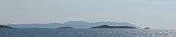
The chain of islands is approximately 10 kilometres (6.2 mi) long, formed of limestone, with a very indented coastline and low pine forest with black pine, and aleppo pine. The highest point on the islands is 94 metres (308 ft). The islands are a popular destination for visitors with smaller craft, especially yachts, providing numerous peaceful coves for diving, underwater fishing, swimming and water sports.[5]
See also
References
- ↑ Pakleni Otoci, Croatia Tourist Center, Croatia, archived from the original on 2009-02-21
- ↑ Island Hvar, retrieved 19 September 2009
- ↑ DRŽAVNI PROGRAM ZAŠTITE I KORIŠTENJA MALIH, POVREMENO NASTANJENIH I NENASTANJENIH OTOKA I OKOLNOG MORA
- ↑ Hvar, Hrvatski Leksikon (in Croatian), II, Zagreb: Naklada Leksikon d.o.o., 1997, p. 223, ISBN 953-96728-2-1
- ↑ Pakleni Otoci, Croatia Traveller: Southern Dalmatia, Croatia