Mrčara
 | |
| Geography | |
|---|---|
| Location | Adriatic Sea |
| Coordinates | 42°46′08″N 16°47′22″E / 42.76889°N 16.78944°ECoordinates: 42°46′08″N 16°47′22″E / 42.76889°N 16.78944°E |
| Archipelago | Lastovo |
| Area | 1.45 km2 (0.56 sq mi) |
| Administration | |
| County | Dubrovnik-Neretva |
Mrčara is a small uninhabited island in the Croatian part of the Adriatic Sea, located west of the islands of Prežba and Lastovo in southern Dalmatia. Its highest peak is 123 m above sea level and its coastline is 7.8 km long.[1]
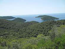
View on Mrčara from Prežba
There is a small jetty on the east coast of the island with a small seasonal restaurant servicing boats that wish to dock there.
In July 2011 the island hosted its first paintball game. Clear shelled and filled paintball's were used so as not to leave any marks on the islands historical fortifications and tunnel complexes. [2]
The island also hosts all weekend and all week Airsoft games as of July 2010.
See also
References
- ↑ Duplančić Leder, Tea; Ujević, Tin; Čala, Mendi (June 2004). "Coastline lengths and areas of islands in the Croatian part of the Adriatic Sea determined from the topographic maps at the scale of 1 : 25 000" (PDF). Geoadria. Zadar. 9 (1): 5–32. Retrieved 2011-01-21.
- ↑ Call to duty III - Event Details
This article is issued from
Wikipedia.
The text is licensed under Creative Commons - Attribution - Sharealike.
Additional terms may apply for the media files.