Primorje-Gorski Kotar County
| Primorje-Gorski Kotar County Primorsko-goranska županija | |||
|---|---|---|---|
| County | |||
| |||
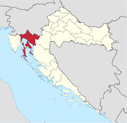 Primorje-Gorski Kotar County within Croatia | |||
| Country | Croatia | ||
| County seat | Rijeka | ||
| Government | |||
| • Župan | Zlatko Komadina (SDP) | ||
| • County Council |
45 members
| ||
| Area[1] | |||
| • Total | 3,588 km2 (1,385 sq mi) | ||
| Population (2011)[2] | |||
| • Total | 296,195 | ||
| • Density | 83/km2 (210/sq mi) | ||
| Area code | 051 | ||
| ISO 3166 code | HR-08 | ||
| Website |
www | ||

Primorje-Gorski Kotar County (Croatian: Primorsko-goranska županija, pronounced [prǐːmorsko-ɡǒranskaː ʒupǎnija]) is a county in western Croatia that includes the Bay of Kvarner, the surrounding Northern Croatian Littoral, and the mountainous region of Gorski kotar. Its center is Rijeka. The county's population was 315,000 in the 2018 census.[3]
The county includes the islands of Krk, Cres, Lošinj and Rab.
Administrative division
The county is divided:
- City of Rijeka
- Town of Bakar
- Town of Cres
- Town of Crikvenica
- Town of Čabar
- Town of Delnice
- Town of Kastav
- Town of Kraljevica
- Town of Krk
- Town of Mali Lošinj
- Town of Novi Vinodolski
- Town of Opatija
- Town of Rab
- Town of Vrbovsko
- Municipality of Baška
- Municipality of Brod Moravice
- Municipality of Čavle
- Municipality of Dobrinj
- Municipality of Fužine
- Municipality of Jelenje
- Municipality of Klana
- Municipality of Kostrena
- Municipality of Lokve
- Municipality of Lovran
- Municipality of Malinska-Dubašnica
- Municipality of Matulji
- Municipality of Mošćenička Draga
- Municipality of Mrkopalj
- Municipality of Omišalj
- Municipality of Punat
- Municipality of Ravna Gora
- Municipality of Skrad
- Municipality of Vinodol
- Municipality of Viškovo
- Municipality of Vrbnik
- Municipality of Lopar
- Island of Ilovik
- Island of Male Srakane
- Island of Vele Srakane
- Island of Susak
- Island of Unije
Demographics
| Historical populations of Primorje-Gorski Kotar County | |||||||||||||||||||||||||||||||||||||||||||||||||||||||
|---|---|---|---|---|---|---|---|---|---|---|---|---|---|---|---|---|---|---|---|---|---|---|---|---|---|---|---|---|---|---|---|---|---|---|---|---|---|---|---|---|---|---|---|---|---|---|---|---|---|---|---|---|---|---|---|
|
| ||||||||||||||||||||||||||||||||||||||||||||||||||||||
| Source: Naselja i stanovništvo Republike Hrvatske 1857–2001, Croatian Bureau of Statistics, Zagreb, 2005 | |||||||||||||||||||||||||||||||||||||||||||||||||||||||
According to the 2011 census, Primorje-Gorski Kotar County has a population of 296,195.[2] Ethnic Croats make up the majority with 86.3% of the population, followed by Serbs at 5.0%.[4]
Protected areas
References
- ↑ Ostroški, Ljiljana, ed. (December 2015). Statistički ljetopis Republike Hrvatske 2015 [Statistical Yearbook of the Republic of Croatia 2015] (PDF). Statistical Yearbook of the Republic of Croatia (in Croatian and English). 47. Zagreb: Croatian Bureau of Statistics. p. 62. ISSN 1333-3305. Retrieved 27 December 2015.
- 1 2 "Population by Age and Sex, by Settlements, 2011 Census: County of Primorje-Gorski kotar". Census of Population, Households and Dwellings 2011. Zagreb: Croatian Bureau of Statistics. December 2012.
- ↑
- ↑ "Population by Ethnicity, by Towns/Municipalities, 2011 Census: County of Karlovac". Census of Population, Households and Dwellings 2011. Zagreb: Croatian Bureau of Statistics. December 2012.
External links
- Official website

| Wikimedia Commons has media related to Primorje-Gorski Kotar County. |
Subdivisions of Primorje-Gorski Kotar County | ||
|---|---|---|
| Cities and towns |  | |
| Municipalities | ||
This article is issued from
Wikipedia.
The text is licensed under Creative Commons - Attribution - Sharealike.
Additional terms may apply for the media files.