Aggenstein
| Aggenstein | |
|---|---|
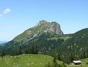 View of the Aggenstein from the Sebenalm | |
| Highest point | |
| Elevation | 1,986 m (6,516 ft) |
| Prominence | 266 m ↓ Unnamed col → Brentenjoch |
| Isolation | 1.8 km → Brentenjoch |
| Coordinates | 47°32′13″N 10°33′29″E / 47.53694°N 10.55806°ECoordinates: 47°32′13″N 10°33′29″E / 47.53694°N 10.55806°E |
| Geography | |
 Aggenstein Alps | |
| Location | Bavaria, Germany / Tyrol, Austria |
| Parent range | Tannheim Mountains, Allgäu Alps |
| Geology | |
| Type of rock | Main dolomite from the Triassic Lechtal nappe |
| Climbing | |
| Easiest route | From Grän (Enge car park) to the Bad Kissinger Hut |
The Aggenstein is a mountain, 1,986 metres high (according to German survey: 1,985.4 m[1]) in the Allgäu Alps on the border Bavaria, Germany and Tyrol, Austria. It is located in the Bavarian part of the Tannheim Mountains, a few kilometres south of Pfronten (Ostallgäu).
Location and surrounding area
The prominence of the Aggenstein is at least 266 metres,[2] its isolation is 1.8 kilometres, the Brentenjoch being the reference peak.
Routes to the summit
- Via Pfronten – Breitenberg – Böser Tritt – Bad Kissinger Hut (Alpine Club hut) – summit (ca. 2.5 hours)
- Via Pfronten Breitenberg – Böser Tritt – Langer Strich – summit (ca. 2 hours); cable car available
- Via Pfronten – Reichenbach-Klamm – Bad Kissinger Hut (Alpine Club hut) – summit (ca. 3.5 hours)
- Via Grän/Enge (Austria) – Bad Kissinger Hut – summit (ca. 2.5 hours)
- Via Grän – Füssener Jöchle – Tannheimer Höhenweg – Bad Kissinger Hut – summit (ca. 2.5 hours); cable car available
References
- ↑ Bayerische Vermessungsverwaltung: BayernViewer 2.0 Archived 2015-09-24 at the Wayback Machine.. Retrieved 26 January 2011.
- ↑ Its exact value is not known; the given value is a minimum - it could be up to 19 metres higher - derived from the contour interval (20 metres) in the 1:25,000 scale map.
This article is issued from
Wikipedia.
The text is licensed under Creative Commons - Attribution - Sharealike.
Additional terms may apply for the media files.