Penrith, New South Wales
| Penrith Sydney, New South Wales | |||||||||||||||
|---|---|---|---|---|---|---|---|---|---|---|---|---|---|---|---|
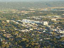 Penrith's central business district and commercial area | |||||||||||||||
| Population | 13,295 (2016 census)[1] | ||||||||||||||
| • Density | 1,078.3/km2 (2,792.7/sq mi) | ||||||||||||||
| Established | 1815 | ||||||||||||||
| Postcode(s) | 2750 | ||||||||||||||
| Area | 12.33 km2 (4.8 sq mi) | ||||||||||||||
| Location | 50 km (31 mi) west of Sydney CBD | ||||||||||||||
| LGA(s) | City of Penrith | ||||||||||||||
| State electorate(s) | Penrith | ||||||||||||||
| Federal Division(s) | Lindsay | ||||||||||||||
| |||||||||||||||
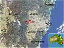
Penrith is a suburb and major centre in the metropolitan area of Sydney, New South Wales, Australia. It is located in Greater Western Sydney 50 kilometres (31 mi) west of the Sydney central business district on the banks of the Nepean River, on the outskirts of the Cumberland Plain. Its elevation is 25 metres (82 ft).
Penrith is the administrative seat of the local government area of the City of Penrith. It is also acknowledged on the register of the Geographical Names Board of New South Wales as one of only four cities within the Sydney metropolitan area.[2]
History
The recorded history of Penrith began on 26 June 1789. Eighteen months after the landing of the First Fleet, an exploring party led by Captain Watkin Tench set out to further discoveries made by Governor Arthur Phillip earlier in the month. In the daylight hours of 27 June, Tench and his party discovered the broad expanse of the Nepean River. Tench’s party became the first Europeans to see what is now the City of Penrith. Tench later wrote ‘we found ourselves on the banks of a river, nearly as broad as the at Putney and apparently of great depth’. Phillip later named the river, after Evan Nepean, the under-secretary of state in the home office, who had been largely responsible for the organisation of the First Fleet. From this point, European settlement began in earnest, firstly on the Hawkesbury River, and later southward up the Nepean.
Indigenous settlement
Prior to the arrival of the Europeans, the Penrith area was home to the Mulgoa tribe of the Darug people. They lived in makeshift huts called gunyahs, hunted native animals such as kangaroos, fished in the Nepean River, and gathered local fruits and vegetables such as yams. They lived under an elaborate system of Law which had its origins in the Dreamtime. Most of the Mulgoa were killed by smallpox or galgala shortly after the arrival of the First Fleet in 1788. Early British explorers such as Watkin Tench described them as friendly, saying, "they bade us adieu, in unabated friendship and good humour".[3]
English settlement
Governor King began granting land in the area to settlers in 1804 with Captain Daniel Woodriff's 1,000 acres (4.0 km2) on the banks of the river the first land grant in the area. The first government building in the district was the military depot built (at the present Penrith police station) by William Cox, in mid-1815 near the new Road (Great Western Road) on unassigned Crown land, set well back from the river. It represented the formalisation of law and order in the district. Its placement seems to have been a practical decision by Cox, placing it on flood-free Crown land on the new road to Parramatta, just east of Woodriff’s Rodley Farm. Governor Lachlan Macquarie paid Cox £200 for ‘erecting a Depot for Provisions, Guard House, erecting necessary Enclosures for cattle and Garden Ground, Frame for a Well … on the new near Emu Ford’. At this time, Emu Ford was one of the few locality names that would indicate the depot’s position.
In 1816 Cox mentioned the lockup at ‘Penryhn’, among a list of expenses. There appears little doubt that he was referring to the depot that was later referred to as Penrith. The name for the new depot, Penrhyn, may have simply been misinterpreted by others. Penrhyn was possibly named after the First Fleet ship that carried women convicts, the Lady Penrhyn. There is no historical evidence to prove Macquarie's hand in naming the depot, especially considering he often endowed and recorded benefactors with that favour. Furthermore, Macquarie would have ensured that a plan of the town would have been drawn up. No documentary evidence has shed any light on Macquarie’s reasoning for the placement of this depot and its connection with his vision for a township at Castlereagh.[4]
What is clear is that the origin of the name, Penrith is steeped in mystery. Penrith was possibly named after Penrith in Cumbria by someone who knew the old town and who noted geographical similarities. By 1819, the name Penrith was in use with its first reference in the Sydney Gazette on 8 December 1821 appointing John Proctor as keeper of the new gaol and court house.
The lockup at Penrith placed government law and order in the centre of the Evan district. This group of buildings became the point of contact for local administration for anything ranging from issuing publican’s licences, holding inquests and church services. Although a magistrate had been appointed to Castlereagh in 1811, the Penrith lockup increased in importance with its promotion to a court house in 1817. A bench of magistrates was appointed: Sir John Jamison, the Reverend Henry Fulton, John McHenry and a military officer from the regiment stationed there.In 1814, William Cox constructed a road across the Blue Mountains which passed through Woodriff's land at Penrith. Initial settlement in the area was unplanned but substantial enough for a courthouse to be established in 1817.[5]
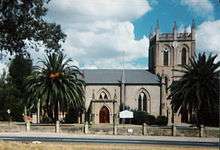
The post office was established in 1828, the Anglican church, St Stephens, was opened and consecrated 16 July 1839[6] followed by the Catholic Church, St Nicholas of Myra, in 1850. Two other prominent Penrith pioneers were Irish-born Thomas Jamison (1752/53-1811), a member of the First Fleet and surgeon-general of New South Wales (after whom Jamisontown is named), and his son, the landowner, physician and constitutional reformer Sir John Jamison (1776–1844). In 1824, Sir John erected the colony's finest Georgian mansion, Regentville House, near Penrith, on a ridge overlooking the Nepean River. Sir John established an impressive agricultural estate at Regentville and became a Member of the New South Wales Legislative Council. His grave can be seen in St Stephen's graveyard. Regentville House burned down in 1868 but most of its stonework was salvaged and used for building projects in and around Penrith.
The first bridge, financed by local business James Tobias (Toby) Ryan was opened over the Nepean in 1856 and was washed away the following year in a flood. The railway line was extended to Penrith in 1863, a school was established in 1865 and in 1871 the area became a municipality. It officially became a city in 1959.[5]
Commercial area
Penrith is one of the major commercial centres in Greater Western Sydney. The suburb contains two shopping centres.
- Westfield Penrith, (formerly Penrith Plaza) is the largest shopping centre in the suburb, located within a main commercial centre.[7]
- Nepean Village is a single level shopping centre located in Penrith.[8]
Transport
Penrith Railway Station is a major railway station on the North Shore, Northern & Western Line of the Sydney Trains network. It has frequent services to and from the City and is also a stop on the intercity Blue Mountains Line.
Penrith railway station has its own bus interchange (as do several major railway stations in Sydney). Penrith is also served by Nightride Bus route 70.
Penrith can be accessed from St. Marys and Mt. Druitt via the Great Western Highway. Access from further east is best obtained by the M4 Western Motorway using either The Northern Road or Mulgoa Road exits. If travelling east from the Blue Mountains, access is best obtained by the Great Western Highway. Access from the south can be obtained by The Northern Road and Mulgoa Road, north from Castlereagh road or Richmond road, or from north and south via Westlink M7 and the M4 Western Motorway.
The NSW Government announced funding for the construction of the M9 in the 2014 state budget[9][10] to connect Camden, Penrith and Windsor. The proposed motorway will start from the M5 motorway and run west of the current M7 motorway.
Education
Penrith Public School and Penrith High School are two public schools in High Street. Jamison High School is in South Penrith. St Nicholas of Myra is a Catholic primary school, which is part of Catholic Education, Diocese of Parramatta, is located in Higgins Street.[5]
The Penrith campus of Nepean College of TAFE is located in the centre of town on Henry Street.[11] The Penrith campus of the University of Western Sydney is located in nearby Werrington.[12] The University of Sydney has a campus near Nepean Hospital in Kingswood, for research into the basic biomedical sciences and educating medical students at the hospital.
Landmarks and tourist attractions
Heritage listings
Penrith has a number of heritage-listed sites, including:
- 34-40 Borec Road: Craithes House[13]
- 26 Coombes Drive: Torin Building[14]
- Great Western railway: Penrith railway station, Sydney[15]
- Nepean River, Great Western Highway: Victoria Bridge (Penrith)[16]
- Off Bruce Neale Dr, Steel Trusses 1.3 km past station: Emu Plains Underbridge[17]
- 1 Museum Drive: Penrith Museum of Fire,[18] including the following:
- Fire and Rescue NSW Heritage Fleet[19]
- NSW Fire Brigades No 10 Vehicle Number Plates[20]
- 1869 Shand Mason 7 inch Manual Fire Engine[21]
- 1891 Shand Mason Fire Engine[22]
- 1898 Shand Mason Curricle Ladders[23]
- 1909 Edward Smith Headquarters Switchboard[24]
- 1929 Ahrens Fox PS2 Fire Engine[25]
- 1939 Dennis Big 6 Fire Engine[26]
- 1942 Ford 21W Fire Brigade Mobile Canteen[27]
Other items of interest include:
- Nepean Belle, an old-world style paddlewheeler located on the Nepean River at Penrith.[28]
- St Stephen's Church (1839),[6] in High Street, and its historic graveyard, is heritage-listed[29]
- Penrith has a campus of the University of Western Sydney
- Sydney International Regatta Centre, which was the location for the rowing competitions for the 2000 Olympic Games[30]
- Panthers World of Entertainment
- Penrith Sake Brewery
- Nepean River
- Head of the River, which takes place at the regatta centre
- Red Cow Hotel, Station Street, is Penrith's oldest standing hotel
- Thornton Hall, Mountain View Crescent, is heritage-listed[31]
- Nepean Park, Castlereagh Road, is heritage-listed[32]
Culture
Arts
The Joan Sutherland Performing Arts Complex is in High Street next to the Council Chambers. Named after opera singer Joan Sutherland, the building was designed by architect Philip Cox and opened in 1990. It incorporates the Penrith Conservatorium of Music and the Q Theatre (Penrith), which had been operating in Station Street for 30 years before moving to the complex in 2006.[33]
Sport and recreation
Peppers Penrith Stadium, home of the Penrith Panthers NRL team. Penrith has a number of local sporting clubs, the best known being the Penrith Panthers rugby league club who play in the National Rugby League. The club (one of the largest in Australia) has a massive entertainment complex and resort, Panthers World of Entertainment. Penrith's Junior Rugby League competition is the largest in the world, which also incorporates teams from the Blue Mountains, Blacktown and Windsor/Richmond areas. Visit the Penrith Junior League Website for more information.
The Panthers' home ground, Penrith Stadium (or Pepper Stadium), is also home to the Penrith Nepean United[34] soccer club. The club has been quite successful, perhaps the team's most memorable result has been a 2–1 Win against Asian Champions League contenders Sydney FC in a home game friendly match in front of 5000 fans on 17 August 2007.
There are also many other sporting associations, including cricket clubs, AFL clubs, Penrith City Outlaws gridiron team,[35] Panthers Triathlon club,[36] Penrith Emus Rugby, swimming, and soccer clubs. For a full list see the Penrith City Council's list of sporting groups.
Just west of Cranebrook is the Penrith Lakes Scheme, a system of flooded quarries that are now recreational lakes. One of these lakes hosted the rowing events of the Sydney 2000 Olympics. This facility is rated as a Level One course which can be used for international events.[37] The course itself is fully buoyed and can be modified to accommodate swimming and kayaking events.
North of the rowing lake is the Penrith Whitewater Stadium, the only pump-powered and artificial whitewater slalom course in the Southern Hemisphere.[38] It was built for the Sydney 2000 Olympics, and it continues to host international competitions on a regular basis.
Penrith is home to the Elite Fight Gym. A mixed martial arts training facility established by UFC fighter James Te-Huna.[39] In 2013, James te Huna left EFG to establish a rival MMA centre in St Mary's named Bee Stingz (located at Valley Fitness).
Media
Penrith is home to three local newspapers: The Western Weekender, Nepean News, and Penrith Press. It is also home to local radio station Vintage FM 87.6 (40's, 50's & 60's Music). NB: the current FM radio station "the edge" 96.1 FM evolved from the former (original) 2KA station founded by Frank Kelly.
Geography

Penrith sits on the western edge of the Cumberland Plain, a fairly flat area of Western Sydney, extending to Windsor in the north, Parramatta in the east and Thirlmere in the south. The Nepean River forms the western boundary of the suburb and beyond that, dominating the western skyline, are the Blue Mountains. There is a difference of opinion between Penrith City Council and the Geographical Names Board of New South Wales as to the boundaries of Penrith the suburb. The Board includes in its official description the area of Kingswood Park, Lemongrove and North Penrith, which the Council considers separate suburbs.[5][40][41]
Climate
Penrith has a humid subtropical climate (Köppen climate classification: Cfa) with hot summers and mild to cool winters. The daytime temperatures are a few degrees warmer than Sydney (Observatory Hill), especially on some spring and summer days, when the difference in temperature between Penrith and the Sydney area can be quite pronounced, and the night-time temperatures are a few degrees cooler than Sydney on most nights of the year. In extreme cases, there could be a temperature differential of 10 degrees Celsius in summer, owing to seabreezes, which affect coastal areas much more than areas further from the ocean and do not usually penetrate as far inland as Penrith. Frost occasionally occurs in some winter mornings. The average summer temperature range is 17.9 °C (64.2 °F) to 29.8 °C (85.6 °F) and in the winter 6.2 °C (43.2 °F) to 18.6 °C (65.5 °F).[42]
Mean yearly rainfall in Penrith is 719.2mm, which is less than Sydney (Observatory Hill) rainfall by 493.0mm (Sydney Observatory Hill's mean yearly rainfall is 1212.2mm [43]), as coastal showers do not penetrate inland. The highest recorded temperature was 47.3 °C (117.14 °F) on 7 January 2018 (Penrith was also the hottest place on earth that day).[44] The lowest recorded temperature was -1.4 °C (29.5 °F) on 12 July 2002.[45][46] Penrith's hot temperatures are credited to föhn wind sweeping off the Central Tablelands down into the foothills of the suburb.[47]
| Climate data for Penrith | |||||||||||||
|---|---|---|---|---|---|---|---|---|---|---|---|---|---|
| Month | Jan | Feb | Mar | Apr | May | Jun | Jul | Aug | Sep | Oct | Nov | Dec | Year |
| Record high °C (°F) | 47.3 (117.1) |
46.9 (116.4) |
40.6 (105.1) |
34.2 (93.6) |
28.4 (83.1) |
26.0 (78.8) |
28.2 (82.8) |
29.7 (85.5) |
37.3 (99.1) |
38.9 (102) |
44.9 (112.8) |
44.1 (111.4) |
47.3 (117.1) |
| Average high °C (°F) | 30.8 (87.4) |
29.3 (84.7) |
27.5 (81.5) |
24.4 (75.9) |
21.0 (69.8) |
18.1 (64.6) |
17.7 (63.9) |
19.9 (67.8) |
23.3 (73.9) |
25.9 (78.6) |
27.3 (81.1) |
29.2 (84.6) |
24.5 (76.1) |
| Daily mean °C (°F) | 24.8 (76.6) |
23.9 (75) |
22.1 (71.8) |
18.8 (65.8) |
15.2 (59.4) |
12.5 (54.5) |
11.6 (52.9) |
13.1 (55.6) |
16.4 (61.5) |
19.0 (66.2) |
21.2 (70.2) |
23.1 (73.6) |
18.4 (65.1) |
| Average low °C (°F) | 18.5 (65.3) |
18.5 (65.3) |
16.6 (61.9) |
13.1 (55.6) |
9.3 (48.7) |
6.9 (44.4) |
5.4 (41.7) |
6.2 (43.2) |
9.4 (48.9) |
12.1 (53.8) |
15.0 (59) |
16.9 (62.4) |
12.3 (54.1) |
| Record low °C (°F) | 10.6 (51.1) |
11.6 (52.9) |
8.3 (46.9) |
3.6 (38.5) |
2.1 (35.8) |
−1.1 (30) |
−1.4 (29.5) |
−0.5 (31.1) |
2.2 (36) |
5.0 (41) |
7.8 (46) |
9.8 (49.6) |
−1.4 (29.5) |
| Average precipitation mm (inches) | 90.4 (3.559) |
131.6 (5.181) |
73.1 (2.878) |
42.2 (1.661) |
40.0 (1.575) |
51.6 (2.031) |
29.6 (1.165) |
30.1 (1.185) |
31.9 (1.256) |
54.5 (2.146) |
82.9 (3.264) |
60.1 (2.366) |
719.2 (28.315) |
| Average precipitation days (≥ 0.2 mm) | 11.5 | 11.7 | 11.8 | 10.3 | 11.6 | 15.2 | 12.4 | 8.5 | 7.5 | 9.3 | 12.1 | 10.7 | 132.6 |
| Average afternoon relative humidity (%) | 47 | 53 | 52 | 49 | 52 | 55 | 50 | 41 | 40 | 41 | 46 | 45 | 48 |
| Source: [48] | |||||||||||||
Population
Demographics
In the 2016 census, Penrith recorded a population of 13,295 people. Of these:[1]
- Age distribution: The median age was 37 years (national median is 38). Children aged under 15 years made up 16.4% of the population (national average is 18.7%) and people aged 65 years and over made up 17.5% of the population (national average is 15.8%).
- Aboriginal and Torres Strait Islander population: Aboriginal and Torres Strait Islander people made up 5.0% of the population of Penrith.
- Ethnic diversity : 68.2% of people were born in Australia, compared to the national average of 66.7%; the next most common countries of birth were England 3.8%, India 2.5%, New Zealand 1.9%, Philippines 1.7% and China 1.4%. 75.6% of people only spoke English at home. Other languages spoken at home included Mandarin 1.4%, Tagalog 1.0% and Arabic 0.9%.
- Religion : The most common responses for religion were No Religion 26.1%, Catholic 24.9% and Anglican 18.1%.
- Finances: The median household weekly income was $1,142, compared to the national median of $1,438. This difference is also reflected in real estate, with the median mortgage payment being $1,733 per month, compared to the national median of $1,755.
- Housing: Nearly half (47.2%) of occupied private dwellings were separate houses, 28.5% were semi-detached (row or terrace houses, townhouses etc.) and 23.8% were flats, units or apartments.
Notable residents

- Richie Benaud (1930-2015) cricketer and commentator
- James Tobias (Toby) Ryan (1818-1899) businessman, politician (Nepean Electorate)
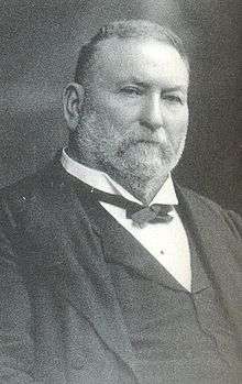
- Thomas Bent (1838–1909) Premier of Victoria 1904 to 1909, born in Penrith
- Nathan Bracken (b. 1977) Australian cricketer
- David Bradbury, former Federal Member of Lindsay, and former Mayor of Penrith
- James Courtney, V8 Race car driver
- Firass Dirani (b. 1984) TV actor
- Jason Dundas (b. 1981) television presenter
- Mick Fanning (b. 1981) surfing world champion 2007
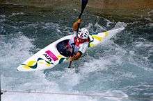
- Jessica Fox (born 1994), French-born Australian slalom canoer, Olympic silver (K-1 slalom), world championships bronze (gold medal at Pau France) (C-1)[49]
- Paige Hadley (b. 1992) netball player
- Michael Hartley (b. 1993), Australian rules footballer[50]
- John Hastings (b. 1985) cricketer
- Tony Jones (b. 1961) sports journalist based in Melbourne.
- Ken Kearney (1924-2006) Duel international, Australian Test and St George premiership-winning captain-coach.
- Simon Keen (b. 1987) Australian U19s cricketer
- Jennifer Maiden (b. 1949) poet
- Darren McErlain (b. 1974) Journalist, poet, teacher, voiceover artist Presents AirFM Drive Penrith
- Nic Naitanui (b. 1990) Australian rules footballer, born in Penrith
- Grigor Taylor (b. 1943) 1970s TV actor
- James Te-Huna UFC Fighter
- Alan Whiticker (b. 1958) non-fiction author
- Melissa Wu (b. 1992) Olympian – diver
- The Holy Soul, rock and roll band
- Mark Geyer (b. 1967) Australian rugby league footballer of the 1980s and 1990s, and a media identity on breakfast radio in Sydney
- Ben St Lawrence (b. 1981) Olympic long-distance runner
- Kent "Smallzy" Small (b. 1984), radio presenter for Nova FM
- David "DC" Love (b. 1985) hip hop recording artist
- Brad Smith (b. 1994), football player for A.F.C. Bournemouth
- Ray Watson, (1922-2010), judge who reformed family law to create no-fault divorce.
- Liam Zammit (b. 1981) cricketer
- also numerous Rugby League players including Greg Alexander, Ben Alexander (1970–1992), Mark Carroll, John Cartwright, Craig Gower, Des Hasler, Michael Jennings, Luke Lewis, Luke Rooney and Tim Sheens.
References
- 1 2 Australian Bureau of Statistics (27 June 2017). "Penrith (State Suburb)". 2016 Census QuickStats. Retrieved 16 September 2017.

- ↑ "Geographical Names Register Extract: List of placenames acknowledged as a CITY" (.CSV). Geographical Names Register (GNR) of NSW. Geographical Names Board of New South Wales. Retrieved 31 August 2008.
- ↑ Christopher Tobin. "The Dharug Story". Mananura Aboriginal Centre. Archived from the original on 29 September 2007. Retrieved 18 May 2008.
- ↑ Stacker, Lorraine (2014). Penrith: The Makings of a City. Penrith City Library: Halstead Press. pp. 17–20. ISBN 978-1-920831-76-9.
- 1 2 3 4 "Local suburb profile – Penrith". Penrith City Council. Archived from the original on 14 June 2008. Retrieved 18 May 2008.
- 1 2 "NINETY YEARS OLD". The Sydney Morning Herald. National Library of Australia. 22 July 1929. p. 11. Retrieved 7 November 2014.
- ↑ "Westfield Penrith | Scentre Group". www.scentregroup.com. Retrieved 2017-02-26.
- ↑ "Nepean Village". www.vicinity.com.au. Retrieved 2017-02-26.
- ↑ Levy, 'NSW budget: Government proposes M9 Outer Sydney Orbital roadway', Sydney Morning Herald Retrieved 11/07/2014
- ↑ Clennell, 'M9 Outer-western Sydney Orbital motorway part of big ticket $5.5b roads package unveiled in today's NSW Budget', The Daily Telegraph Retrieved 11/07/2014
- ↑ TAFE NSW – Campuses & Institutes Retrieved 18 June 2009
- ↑ Penrith | University of Western Sydney (UWS) Retrieved 18 June 2009
- ↑ "Craithes House, New South Wales State Heritage Register (NSW SHR) Number H00378". New South Wales State Heritage Register. Office of Environment and Heritage. Retrieved 18 May 2018.
- ↑ "Torin Building, New South Wales State Heritage Register (NSW SHR) Number H01796". New South Wales State Heritage Register. Office of Environment and Heritage. Retrieved 18 May 2018.
- ↑ "Penrith Railway Station group, New South Wales State Heritage Register (NSW SHR) Number H01222". New South Wales State Heritage Register. Office of Environment and Heritage. Retrieved 18 May 2018.
- ↑ "Victoria Bridge, New South Wales State Heritage Register (NSW SHR) Number H01950". New South Wales State Heritage Register. Office of Environment and Heritage. Retrieved 18 May 2018.
- ↑ "Emu Plains (Nepean River) Underbridge, New South Wales State Heritage Register (NSW SHR) Number H01830". New South Wales State Heritage Register. Office of Environment and Heritage. Retrieved 18 May 2018.
- ↑ Penrith Museum of Fire Archived 11 April 2006 at the Wayback Machine. Retrieved 18 June 2009
- ↑ "Fire and Rescue NSW Heritage Fleet, New South Wales State Heritage Register (NSW SHR) Number H01902". New South Wales State Heritage Register. Office of Environment and Heritage. Retrieved 18 May 2018.
- ↑ "NSW Fire Brigades No 10 Vehicle Number Plates, New South Wales State Heritage Register (NSW SHR) Number H01519". New South Wales State Heritage Register. Office of Environment and Heritage. Retrieved 18 May 2018.
- ↑ "Shand Mason 7 inch Manual Fire Engine (1869), New South Wales State Heritage Register (NSW SHR) Number H01898". New South Wales State Heritage Register. Office of Environment and Heritage. Retrieved 18 May 2018.
- ↑ "Shand Mason Fire Engine (1891), New South Wales State Heritage Register (NSW SHR) Number H01716". New South Wales State Heritage Register. Office of Environment and Heritage. Retrieved 18 May 2018.
- ↑ "Shand Mason Curricle Ladders (1898), New South Wales State Heritage Register (NSW SHR) Number H01899". New South Wales State Heritage Register. Office of Environment and Heritage. Retrieved 18 May 2018.
- ↑ "Edward Smith Headquarters Switchboard (1909), New South Wales State Heritage Register (NSW SHR) Number H01901". New South Wales State Heritage Register. Office of Environment and Heritage. Retrieved 18 May 2018.
- ↑ "Ahrens Fox PS2 Fire Engine (1929), New South Wales State Heritage Register (NSW SHR) Number H01717". New South Wales State Heritage Register. Office of Environment and Heritage. Retrieved 18 May 2018.
- ↑ "Dennis Big 6 Fire Engine (1939), New South Wales State Heritage Register (NSW SHR) Number H01718". New South Wales State Heritage Register. Office of Environment and Heritage. Retrieved 18 May 2018.
- ↑ "Ford 21W Fire Brigade Mobile Canteen (1942), New South Wales State Heritage Register (NSW SHR) Number H01900". New South Wales State Heritage Register. Office of Environment and Heritage. Retrieved 18 May 2018.
- ↑ "Nepean Belle Paddlewheeler 02 4733 1274". Nepean Belle Paddlewheeler 02 4733 1274.
- ↑ The Heritage of Australia, Macmillan Company (1981) p. 2/58
- ↑ Sydney International Regatta Centre – Official Website
- ↑ State Heritage Register
- ↑ The Heritage of Australia, Macmillan Company (1981) p.2/58
- ↑ "Joan Sutherland Performing Arts Complex". Tourism NSW. Archived from the original on 14 June 2008. Retrieved 22 May 2008.
- ↑ "Penrith Nepean United Football Club". Penrith Nepean United. Archived from the original on 1 December 2008. Retrieved 29 December 2008.
- ↑ "Penrith City Outlaws". Penrith City Outlaws. Archived from the original on 27 March 2009. Retrieved 29 December 2008.
- ↑ "Panthers Triathlon Club". Panthers Triathlon Club. Retrieved 29 December 2008.
- ↑ "Sydney International Regatta Centre, Penrith Club". SIRC. Archived from the original on 29 January 2009. Retrieved 29 December 2008.
- ↑ A review of past and future Olympic Venues Retrieved 20 June 2009
- ↑ "Elite Fight Gym - Just another WordPress site". elitefightgym.com.au.
- ↑ "Cumberland Plain Vegetation Mapping Project". NSW Department of Environment & Climate Change. Retrieved 22 May 2008.
- ↑ "City of Penrith". Penrith City Council. Archived from the original on 3 September 2007. Retrieved 22 May 2008.
- ↑ "Climate statistics for Penrith Lakes". Bureau of Meteorology. Retrieved 21 Feb 2015.
- ↑ "Climate statistics for Sydney Observatory Hill". Bureau of Meteorology. Retrieved 21 Feb 2015.
- ↑ Ben Domensino. "Was Penrith the hottest place on Earth on Sunday?". Weatherzone. Retrieved 8 January 2018.
- ↑ @BOM_NSW (7 January 2018). ""#SydneyHeat UPDATE: #Penrith has now reached 47.3 degrees at 3:25pm according to the preliminary live data from the weather station there."" (Tweet) – via Twitter.
- ↑ "Climate statistics for Penrith Lakes". Bureau of Meteorology. Retrieved 18 May 2008.
- ↑ Sharples, J.J., McRae, R.H.D., Weber, R.O., Mills, G.A. (2009) Foehn-like winds and fire danger anomalies in southeastern Australia. Proceedings of the 18th IMACS World Congress and MODSIM09. 13–17 July, Cairns.
- ↑ "Climate statistics for Penrith Lakes". Australian Bureau of Meteorology.
- ↑ "Jewish Australian kayaker Jessica Fox takes silver medal". Jewish Telegraphic Agency.
- ↑ Twomey, Callum (28 March 2018). "Why getting sacked by the Pies was 'a blessing'". Australian Football League. Retrieved 28 March 2018.
| Wikimedia Commons has media related to Penrith, New South Wales. |
External links
- Visit Penrith – Penrith City Council Tourism website
- Future plan for Penrith CBD
- – Nepean Belle Paddlewheeler
- Penrith City Council website
- Penrith City History
- Penrith Panthers Rugby League Club
- Penrith on Visit NSW
- Penrith News & Events
- Western Weekender Newspaper
- SYDNEY.com – Penrith
- Ailsa McPherson (2015). "Q Theatre". Dictionary of Sydney. Dictionary of Sydney Trust. Retrieved 11 October 2015. [CC-By-SA]
Coordinates: 33°45′29″S 150°42′20″E / 33.75801°S 150.70544°E