Peleliu
| Peleliu | ||
|---|---|---|
| State | ||
| ||
 Location of Peleliu in Palau | ||
| Coordinates: 7°0′N 134°15′E / 7.000°N 134.250°ECoordinates: 7°0′N 134°15′E / 7.000°N 134.250°E | ||
| Country |
| |
| Capital | Kloulklubed | |
| Area | ||
| • Total | 13 km2 (5 sq mi) | |
| Population (2000) | ||
| • Total | 571 | |
| • Density | 44/km2 (110/sq mi) | |
| ISO 3166 code | PW-228 | |
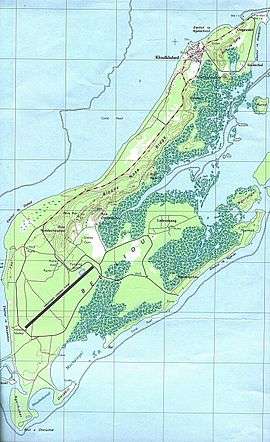
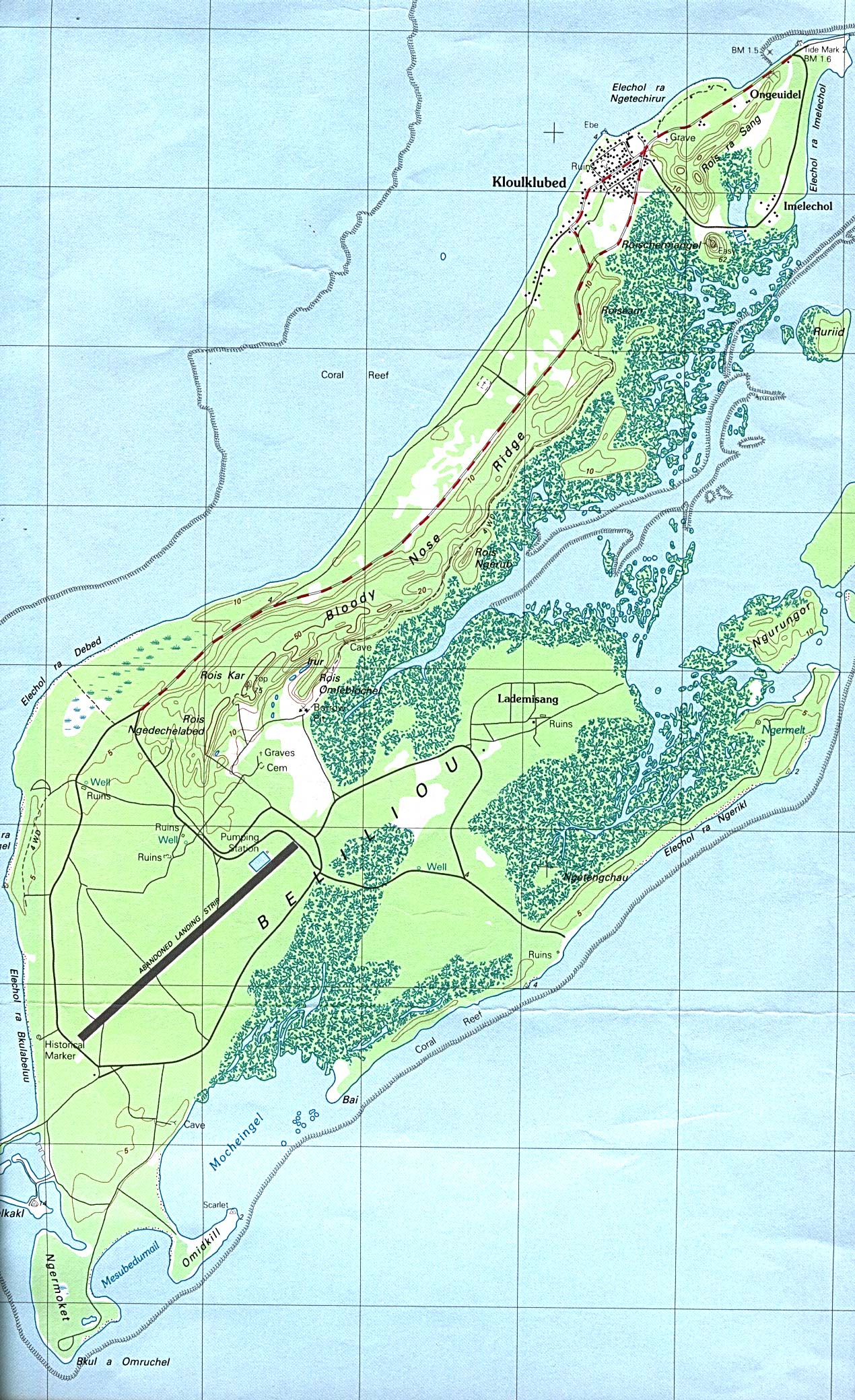
Peleliu (or Beliliou) is an island in the island nation of Palau. Peleliu forms, along with two small islands to its northeast, one of the sixteen states of Palau. The island is notable as the location of the Battle of Peleliu in World War II.
Geography
Peleliu is approximately 10 kilometres (6.2 mi) northeast of the island of Angaur and 40 kilometres (25 mi) southwest of the island of Koror. Peleliu has a total area of 13 square kilometres (5.0 sq mi). As of 2000, its population was about 571, making it the third most populous state of Palau.[1] Most of the island's population lives in the village of Kloulklubed which is the state capital on the northwestern coast. Including the capital, there are a total of four villages:
- Kloulklubed (northwest)
- Imelechol (northeast)
- Lademisang (southernmost, in the central part of the island)
- Ongeuidel (northernmost)
History
First sighting of Peleliu, Babeldaob, and Koror recorded by Westerners was by the Spanish expedition of Ruy López de Villalobos at the end of January 1543. They were then charted as Los Arrecifes ("The Reefs" in Spanish).[2] In November and December 1710 these three islands were again visited and explored by the Spanish missionary expedition commanded by Sargento Mayor Francisco Padilla on board of the patache Santísima Trinidad. Two years later they were explored in detail by the expedition of Spanish naval officer Bernardo de Egoy.[3] Following its defeat in the Spanish–American War, Spain sold Palau (including Peleliu) to Germany in 1899. Control passed to Japan in 1914.
During World War II, the Battle of Peleliu was a major battle between units of the United States Marine Corps and United States Army against the Imperial Japanese Army. The battle for the island was particularly brutal because by this time the Japanese military had evolved island defense tactics with strong fortifications in the island's caves and rock formations, which enabled a defense in depth which maximized casualties on the attacking force. On both sides involved in the fighting there were high losses with more than 2,000 Americans and 10,000 Japanese killed, but, remarkably, there were no casualties among the local civilians because they were evacuated from the fighting to other islands of Palau.
The ruins of many of the military installations of the era, such as the airstrip, are still intact, and shipwrecks from the battle remain visible underwater just off the coast. There are war memorials on the island to both the American and the Japanese dead. Peleliu and Angaur were the only islands in the Palau archipelago to be occupied by the Americans during the war. The capital of Koror remained in Japanese hands to the end of the war.
Peleliu passed formally to the United States under United Nations auspices in 1947 as part of the Trust Territory of the Pacific Islands. Palau became independent in 1978, and Peleliu was organized as a state within the new republic. In August 2014, Peleliu hosted the "leader's retreat" at the 45th Pacific Islands Forum, featuring representatives from the forum's 15 member states.[4]
Infrastructure
Peleliu Airfield, created by the Japanese in World War II, has the longest and widest runway in Palau (1,850 metres (6,070 ft)), but has been used only by small chartered aircraft after Palau's domestic flights were discontinued in late 2005. A regular boat service connects the island twice a week to Koror and Angaur. Travel time by boat from Koror is over an hour. The small harbor in the far north of the island is shallow and suitable only for yachts with shallow draft.
Peleliu Battlefield
|
Peleliu Battlefield | |
| Location | Peleliu, Palau |
|---|---|
| Area | 7,680 acres (3,110 ha) |
| Built | 1944 |
| NRHP reference # | 85001754[5] |
| Added to NRHP | February 4, 1985 |
The entire island has been listed on the National Register of Historic Places as the Peleliu Battlefield, and has been designated a U.S. National Historic Landmark.[6]
Education
The Ministry of Education operates public schools.
Peleliu Elementary School opened in 1946, and had its second building open in 1966, with the first still in use.[7]
Palau High School in Koror is the country's only public high school, so children from this community go there.[8]
References
- ↑ Patterson, Carolyn Bennett, et al. "At the Birth of Nations: In the Far Pacific." National Geographic Magazine, October 1986 page 493. National Geographic Virtual Library, Accessed 17 May 2018. "An example is Peleliu, the tragic island where more than 13,000 Americans and Japanese died during less than three months of fighting, often hand to hand, in the autumn of 1944. Pat and I went to Peleliu from Koror, the republic's capital, by speedboat, a wave-tossing, rear-slapping 45 minutes, and arrived to discover it was election day, with five candidates running for governor. Although Peleliu claims a population of 2,000 people, only 400 actually live there. More registered voters live in Koror than on their home island, and 800 send votes from Guam. The situation is similar in Palau's other states."
- ↑ Burney, James A chronological history of the discoveries in the South Sea or Pacific Ocean, London, 1813, v.I, p.233.
- ↑ Coello, Francisco "Conflicto hispano-alemán" Boletín de Sociedad Geográfica de Madrid, t.XIX. 2º semestre 1885, Madrid, p.296.
- ↑ Calendar of Events Archived 2015-01-21 at the Wayback Machine. – Palau PIF. Retrieved 21 January 2015.
- ↑ National Park Service (2010-07-09). "National Register Information System". National Register of Historic Places. National Park Service.
- ↑ National Park Service (2009-03-13). "National Register Information System". National Register of Historic Places. National Park Service.
- ↑ "Peleliu Elementary School." Ministry of Education (Palau). Retrieved on February 22, 2018.
- ↑ "About." Palau High School. Retrieved on February 22, 2018.
External links
| Wikimedia Commons has media related to Peleliu. |
- Map of Peleliu
- Peleliu National Historical Park Study Preliminary Draft
- Bloody Peleliu
- Photos of WW2-era relics and equipment on Peleliu
- Honorary Consulate of the Republic of Palau to the UK &NI
| Topics | |
|---|---|
| Lists by states |
|
| Lists by insular areas | |
| Lists by associated states | |
| Other areas | |
| |