Ngeremlengui
| Ngeremlengui | ||
|---|---|---|
| State | ||
| ||
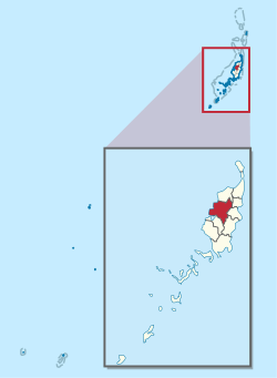 Location of Ngeremlengui in Palau | ||
| Country |
| |
| Capital | Imeong | |
| Area | ||
| • Total | 65 km2 (25 sq mi) | |
| Population (2005) | ||
| • Total | 317 | |
| • Density | 4.9/km2 (13/sq mi) | |
| ISO 3166 code | PW-227 | |
Ngeremlengui (also spelled Ngaremlengui[1]) is one of Palau's sixteen states. It has a population of about 317 (according to the 2005 census), and is just west of the capital in Melekeok state. The capital of the state of Ngeremlengui is Imeong. Ngeremlengui is on the western side of Babeldaob, which is the largest island in Palau. Ngarelemgui is the largest of Palau's sixteen states in terms of land, and has an area of roughly 65 km2.
Education
The Ministry of Education operates public schools.
Ngeremlengui Elementary School opened in 1945. Its permanent building was established around 1946.[2]
Palau High School in Koror is the country's only public high school, so children from this community go there.[3]
References
- ↑ https://www.google.co.jp/search?dcr=0&source=hp&ei=N2X-WrnXMcWz0gSFlpSYDw&q=Ngaremlengui&oq=Ngaremlengui&gs_l=psy-ab.3..0j0i10i30k1l2.647.5500.0.6707.2.2.0.0.0.0.492.708.2-1j0j1.2.0....0...1.1.64.psy-ab..0.2.705...0i30k1.0._IiBH2T2J-8
- ↑ "Ngeremlengui Elementary School." Ministry of Education (Palau). Retrieved on February 22, 2018.
- ↑ "About." Palau High School. Retrieved on February 22, 2018.
External links
Flag of Ngeremlengui:
More info. on Ngeremlengui:
Coordinates: 7°32′24″N 134°31′12″E / 7.54000°N 134.52000°E