Koror
| Koror | ||
|---|---|---|
| State | ||
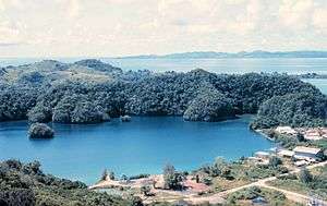  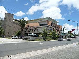 From top to bottom: Palau boatyard on Malakal Island (August 1973), Downtown of Koror and WCTC Shopping Center | ||
| ||
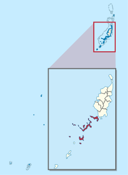 Location of Koror State in Palau | ||
 Koror Location of Koror State in Palau | ||
| Coordinates: 7°20′32″N 134°28′38″E / 7.34222°N 134.47722°E | ||
| Country |
| |
| Capital | Koror City | |
| Population (2004) | ||
| • Total | 14,000 | |
| ISO 3166 code | PW-150 | |
| Website |
kororstategov | |
Koror is the state comprising the main commercial centre of the Republic of Palau. It consists of several islands, the most prominent being Koror Island (also Oreor Island).
The state of Koror (population 14,000 as of 2004) contains about 70% of the population of the country. The nation's former capital and largest town, also called Koror or Koror City, is located here. The town has a population of 11,200 and is located at 7°20′32″N 134°28′38″E / 7.34222°N 134.47719°ECoordinates: 7°20′32″N 134°28′38″E / 7.34222°N 134.47719°E.[1] On 7 October 2006, Ngerulmud replaced Koror as Palau's capital city.
History
The first sighting of Koror, Babeldaob, and Peleliu recorded by Westerners was by the Spanish expedition of Ruy López de Villalobos at the end of January, 1543. They were then charted as Los Arrecifes (The Reefs in Spanish).[2] In November and December 1710 these three islands were again visited and explored by a Spanish missionary expedition commanded by Sargento Mayor Francisco Padilla on board the patache Santísima Trinidad. Two years later they were explored in detail by the expedition of Spanish naval officer Bernardo de Egoy.[3]
Overview
The island of Koror is connected by bridges to three neighbouring islands:
- Ngerekebesang Island, the site of Palau's second-largest town, Meyuns, in the eastern part of the island, with a population of 1,200.
- Malakal Island, the site of Koror's port.
- Koror Island is also connected by the Koror–Babeldaob Bridge to the state of Airai in the island of Babeldaob, where Palau International Airport is located.
Besides the former capital Koror and the town of Meyuns, there are a total of 11 hamlets in the state of Koror:
- Ngermid
- Ngerkeseuaol
- Ngerchemai
- Iyebukel
- Idid
- Meketii
- Dngeronger
- Ikelau
- Medalaii
- Ngerbeched
- Ngerkebesang
Koror was the capital of the former Japanese mandated territory of Nanyo.
Tourism
Much of Palau's economy comes from tourism. The Rock Islands of Palau are all located in the state. Scuba diving shops and facilities are located all over Koror. Accommodation like hotels, bars, restaurants, cafes, and resorts are all available. Dolphins Pacific, the world's largest dolphin research facility, is open for tourists who are interested in swimming and interacting with trained dolphins.[4] Most tourists to Palau stay in Koror, which is the centre for Palau's resort services and house modern conveniences. Koror has businesses that cater to speakers of many languages.[5]
By 2001, the Koror Jail, Palau's only correctional facility, has become a tourist destination thanks to inmates who create and sell elaborate wooden storyboards at a retail facility located on the jail's grounds.[6]
Climate
Koror features a tropical rainforest climate under the Köppen climate classification. The town experiences an extraordinary amount of rainfall annually, averaging around 3,750 millimetres (148 in) of precipitation annually. As with many areas with this climate type, temperatures remain relatively constant throughout the course of the year, averaging roughly 27 °C (81 °F).
| Climate data for Koror (1981−2010 normals, extremes 1951−present)[lower-alpha 1] | |||||||||||||
|---|---|---|---|---|---|---|---|---|---|---|---|---|---|
| Month | Jan | Feb | Mar | Apr | May | Jun | Jul | Aug | Sep | Oct | Nov | Dec | Year |
| Record high °C (°F) | 34 (93) |
34 (93) |
34 (94) |
34 (94) |
34 (94) |
35 (95) |
34 (93) |
34 (94) |
33 (92) |
34 (93) |
34 (93) |
34 (94) |
35 (95) |
| Average high °C (°F) | 30.3 (86.5) |
30.2 (86.4) |
30.6 (87.1) |
31 (87.8) |
30.9 (87.7) |
30.4 (86.8) |
30.1 (86.1) |
30 (86.0) |
30.3 (86.5) |
30.6 (87.0) |
31 (87.8) |
30.7 (87.2) |
30.5 (86.9) |
| Average low °C (°F) | 24.6 (76.3) |
24.5 (76.1) |
24.6 (76.3) |
24.9 (76.9) |
25 (77.0) |
24.7 (76.4) |
24.7 (76.4) |
25 (77.0) |
25 (77.0) |
25.1 (77.1) |
25 (77.0) |
24.8 (76.7) |
24.8 (76.7) |
| Record low °C (°F) | 21 (69) |
22 (71) |
21 (69) |
21 (69) |
22 (71) |
22 (71) |
21 (70) |
21 (70) |
21 (70) |
22 (71) |
21 (70) |
22 (71) |
21 (69) |
| Average precipitation mm (inches) | 281.7 (11.09) |
242.3 (9.54) |
210.1 (8.27) |
208 (8.19) |
318 (12.52) |
457.5 (18.01) |
460.2 (18.12) |
353.6 (13.92) |
307.1 (12.09) |
306.3 (12.06) |
302.3 (11.90) |
303 (11.93) |
3,750.1 (147.64) |
| Average precipitation days (≥ 0.25 mm) | 23.2 | 19.6 | 20.0 | 18.7 | 23.3 | 25.1 | 24.1 | 20.4 | 19.9 | 21.6 | 22.9 | 24.6 | 263.4 |
| Average relative humidity (%) | 84.3 | 83.7 | 83.8 | 83.3 | 85.4 | 86.2 | 85.3 | 84.9 | 83.7 | 84.8 | 85.1 | 85.0 | 84.6 |
| Mean monthly sunshine hours | 199.8 | 194.5 | 244.0 | 234.2 | 212.3 | 168.9 | 186.9 | 176.8 | 197.2 | 179.5 | 183.3 | 183.1 | 2,360.5 |
| Percent possible sunshine | 55 | 58 | 65 | 63 | 55 | 45 | 48 | 46 | 54 | 48 | 52 | 50 | 53 |
| Source: NOAA (relative humidity and sun 1961−1990)[7][8][9] | |||||||||||||
Demographics
In 2002, of the 17,000 people living in Palau, 68% lived in Koror.[5]
Economy
Belau Air has its headquarters in Koror,[10] as did the short-lived Pacific Flier in 2010.[11]
Education
Schools in Koror operated by the Ministry of Education include:
- Palau High School
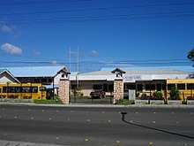
- Koror Elementary School - It opened in 1945 after World War II. The current building opened in 1969 as Typhoon Sally destroyed the previous one.[12]
- George B. Harris Elementary School in eastern Koror - Named after a member of the Land Registration Team of Palau, it was built in 1964 to relieve Koror Elementary.[13]
- Meyuns Elementary School in Meyuns - It was built circa 1969 and expanded in 1973. It was established since Typhoon Sally destroyed Koror Elementary, where Meyuns students previously attended. The Trust Territory of the Pacific Islands administration was previously uninterested in building a school in Melyuns.[14]
Notable residents
- Prince Lee Boo (1764-1784)
See also
Notes
- ↑ To access the data. Click on NOWdata, then choose "View Map" under location then choose "Show more stations", select Koror WSO and choose Daily/monthly normal and monthly summarized data for normals and extremes
References
- ↑ "Archived copy". Archived from the original on 2012-05-04. Retrieved 2007-04-06.
- ↑ Burney, James A chronological history of the discoveries in the South Sea or Pacific Ocean, London, 1813, v.I, p.233.
- ↑ Coello, Francisco "Conflicto hispano-alemán" Boletín de Sociedad Geográfica de Madrid, t.XIX. 2º semestre 1885, Madrid, p.296.
- ↑ "Dolphins Pacific". 2008-08-22. Retrieved 2008-11-26.
- 1 2 "Palau General Information Provided by the Palau Environmental Quality Protection Board for the 21st Annual Pacific Islands Environment Conference." U.S. Environmental Protection Agency. Retrieved on October 7, 2010.
- ↑ David Leonard and David Pickell (2001). Diving the Pacific: Volume 1: Micronesia and the Western Pacific Islands. Tuttle Publishing. p. 89. ISBN 962-593-499-5.
- ↑ "NowData - NOAA Online Weather Data". National Oceanic and Atmospheric Administration. Retrieved 10 March 2015.
- ↑ "PW Koror WSO". National Oceanic and Atmospheric Administration. Retrieved 10 March 2015.
- ↑ "WMO climate normals for Koror/W Caroline Islands, PI 1961−1990". National Oceanic and Atmospheric Administration. Retrieved 10 March 2015.
- ↑ "About Belau Air". Belau Air. Retrieved on July 6, 2010.
- ↑ "Regional Offices". Pacific Flier. Retrieved on July 6, 2010. Archived March 4, 2011, at the Wayback Machine.
- ↑ "Koror Elementary School." Ministry of Education (Palau). Retrieved on February 22, 2018.
- ↑ "George B. Harris Elementary School." Ministry of Education (Palau). Retrieved on February 22, 2018.
- ↑ "Meyuns Elementary School." Ministry of Education (Palau). Retrieved on February 22, 2018.
External links
![]()
![]()